Gailes, Queensland facts for kids
Quick facts for kids GailesIpswich, Queensland |
|||||||||||||||
|---|---|---|---|---|---|---|---|---|---|---|---|---|---|---|---|

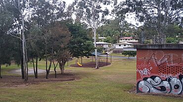
Fred Ferguson Park, 2023
|
|||||||||||||||
| Population | 1,831 (2021 census) | ||||||||||||||
| • Density | 1,410/km2 (3,700/sq mi) | ||||||||||||||
| Postcode(s) | 4300 | ||||||||||||||
| Area | 1.3 km2 (0.5 sq mi) | ||||||||||||||
| Time zone | AEST (UTC+10:00) | ||||||||||||||
| Location |
|
||||||||||||||
| LGA(s) | City of Ipswich | ||||||||||||||
| State electorate(s) | Jordan | ||||||||||||||
| Federal Division(s) | Oxley | ||||||||||||||
|
|||||||||||||||
Gailes is a suburb located in Ipswich, a city in Queensland, Australia. It is part of the City of Ipswich area. In 2021 census, Gailes was home to 1,831 people.
Contents
Exploring Gailes' Location
Gailes is bordered by the Ipswich Motorway and the Main Line railway to the north. To the west, you'll find Woogaroo Creek. This creek flows into the Brisbane River.
Most of Gailes is made up of homes. There's also a small area of undeveloped bushland in the south-west.
A Look Back at Gailes' History
In 1823, an explorer named John Oxley discovered a high point in the area. He called it Dingo Hill. This name became popular for the whole area. Because of this, a local train stop was also named Dingo Hill.
On September 16, 1925, the Dingo Hill train stop was improved. It was renamed Gailes railway station. The name "Gailes" comes from a golf club in Ayrshire, Scotland. The word Gailes means "overgrown by bog-myrtle". The suburb of Gailes got its name from this train station.
Later, in 1986, the suburb boundaries changed. This meant that Gailes railway station is now actually in the nearby suburb of Wacol. Also, Dingo Hill is now part of the suburb of Camira.
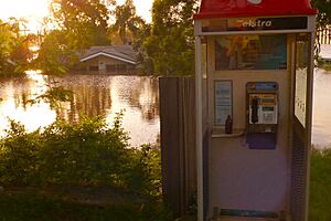
In January 2011, Gailes experienced flooding during the 2011 Queensland floods.
Who Lives in Gailes?
Let's look at how many people have lived in Gailes over the years:
- In 2011 census, there were 1,646 people living in Gailes.
- By 2016 census, the population grew to 1,828 people.
- In the most recent 2021 census, Gailes had a population of 1,831 people.
Getting Around Gailes
There isn't a train station directly inside Gailes. However, you can easily reach nearby stations. The closest ones are Goodna railway station and Gailes railway station. Both offer regular train services. These trains can take you to Brisbane, Ipswich, and Rosewood.
Schools Near Gailes
Gailes itself doesn't have any schools. But there are schools very close by for students.
- The nearest primary school is Camira State School. It's in the neighbouring suburb of Camira.
- For high school, students can go to Bellbird Park State Secondary College. This school is in Bellbird Park.
- Another option is Woodcrest State College in Springfield.
Important Places in Gailes
The Gailes Post Office is located at the Gailes Shopping Centre. You can find it at 65 Old Logan Road. This is where you can send mail and access other postal services.
Parks and Green Spaces
Gailes has several parks where you can relax and play:
- Fred Ferguson Park
- Knoblanche Park
- Lowry Park
- Martin Coogan Park
- Noble Park
 | Claudette Colvin |
 | Myrlie Evers-Williams |
 | Alberta Odell Jones |


