
Jean Marie River facts for kids
Quick facts for kids
Jean Marie River
Tthek'éhdélį or Tthek'edeli
|
|
|---|---|
|
First Nation - Designated Authority
(Tthek'éhdélį First Nation) |
|

Jean Marie River
|
|

Jean Marie River
Location in Northwest Territories

Jean Marie River
Location in Canada
|
|
| Country | Canada |
| Territory | Northwest Territories |
| Region | Dehcho Region |
| Constituency | Nahendeh |
| Census division | Region 4 |
| Area | |
| • Land | 37.35 km2 (14.42 sq mi) |
| Elevation | 143 m (469 ft) |
| Population
(2016)
|
|
| • Total | 77 |
| • Density | 2.1/km2 (5/sq mi) |
| Time zone | UTC−07:00 (MST) |
| • Summer (DST) | UTC−06:00 (MDT) |
| Canadian Postal code |
X0E 0N0
|
| Area code(s) | 867 |
| Telephone exchange | 809 |
| - Living cost | 142.5 |
| Website | www.jmrfn.com |
| Sources: Department of Municipal and Community Affairs, Prince of Wales Northern Heritage Centre, Canada Flight Supplement Postal code shared with Fort Simpson 2013 figure based on Edmonton = 100 |
|
Jean Marie River is a small community in the Northwest Territories of Canada. Its name in the Slavey language is Tthek'éhdélį or Tthek'edeli, which means "water flowing over clay."
This community is located in the Dehcho Region. It sits right where the Jean Marie River flows into the much larger Mackenzie River.
Jean Marie River has a small airport, Jean Marie River Airport. You can reach the community by charter plane all year round. There's also a road, the JMR Access Road, which is about 27 kilometers (17 miles) long and connects to the Mackenzie Highway.
Contents
Understanding the Population of Jean Marie River
The number of people living in Jean Marie River changes over time. Governments keep track of these numbers to understand how communities are growing or shrinking.
Population Changes Over Time
|
|||||||||||||||||||||||||||||||||||||||
|
||||||||||||||||||||||||||||||||||||||||||||||||||||||||||||||||||||||||||||||
In 2021, a count of the population showed that 63 people lived in Jean Marie River. They lived in 33 homes. This was a small change from 2016, when 77 people lived there.
The land area of the community is about 37.5 square kilometers (14.5 square miles). In 2021, there were about 1.7 people living in each square kilometer.
Most people in Jean Marie River are First Nations. The main languages spoken are Dene Zhatie (which is also called South Slavey) and English.
Community Services and Facilities
Even though it's a small community, Jean Marie River has some important services for its residents.
Health and Safety
The Royal Canadian Mounted Police (RCMP) help keep the community safe. Police services are provided from the nearby town of Fort Simpson.
There isn't a hospital in Jean Marie River. However, there is a health station called the "Jean Marie Health Cabin." This is where people can go for basic health care.
Shopping and Visitors
Currently, there isn't a grocery store in Jean Marie River. But, there are places for visitors to stay. There is also a visitors center where you can learn more about the area.
Education for Students
Children in Jean Marie River go to the Louie Norwegian School. This school teaches students up to Grade 10.
First Nations People of Jean Marie River
The Dene people are the original inhabitants of this area. The community's Dene people are part of the Jean Marie River First Nation. This First Nation belongs to a larger group called the Dehcho First Nations.
Mackenzie River Flooding Event
On May 7, 2021, the Mackenzie River flooded. This flood caused a lot of damage in Jean Marie River.
Impact of the Flood
- Out of 26 homes in the community, 22 were damaged.
- The only school was also damaged.
- The power plant that supplied electricity to the community stopped working.
- There were also spills of diesel fuel, which made many homes smell strongly.
Rebuilding After the Flood
Rebuilding efforts started by June 9. However, residents felt that the authorities were slow to help. They also needed more guidance on how to clean up the fuel spills in their homes.
Gallery
- Around Jean Marie River
-
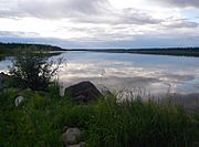
Jean Marie River, Mackenzie River
-
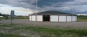
Jean Marie River, ceremonial house
-
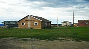
Houses in Jean Marie River
-
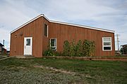
Louie Norwegian School


