
Jefferson Pier facts for kids

The Jefferson Pier, also called the Jefferson Stone, is a special stone marker in Washington, D.C.. It marks what was meant to be the second main starting point for measuring distances (a "prime meridian") in the United States. Even though it was never officially recognized by the government, it's an important part of American history and how the capital city was planned.
Contents
Where is the Jefferson Pier Located?

This stone is found on the National Mall, a large open area in Washington, D.C. It's almost directly south of the middle of the White House. It's also west of the United States Capitol building and north of the Jefferson Memorial. The stone is about 391 ft (119 m) northwest of the Washington Monument.
The monument itself is a large block of granite. It measures about 2.25-by-2.25-foot (0.7 m × 0.7 m) at its base and stands 3-foot (0.9 m) tall. On its top, you can see lines carved into it that show where the longitude and latitude lines cross. One side of the stone has an inscription, but part of it was removed.
The inscription says:
POSITION OF JEFFERSON
PIER ERECTED DEC 18, 1804.
RECOVERED AND RE-ERECTED
DEC 2, 1889.
[fifth line chiseled out]
DISTRICT OF COLUMBIA
The part that was carved out supposedly used to say: "BEING THE CENTRE POINT OF THE".
Planning Washington, D.C.'s Layout

When Pierre Charles L'Enfant designed the city of Washington in 1791, he included a main meridian line. This line, which marked 0 degrees longitude, was planned to go through the future site of the U.S. Capitol. Thomas Jefferson, who was the Secretary of State at the time, helped oversee L'Enfant's work. Jefferson wanted the United States to be independent in science, just like it was in politics. He hoped the new capital city would have its own "first meridian" for mapping.
L'Enfant's city plan featured a big right triangle. One side of this triangle was a wide avenue, now part of Pennsylvania Avenue. This avenue connected the "President's house" (the White House) and the "Congress house" (the U.S. Capitol). To complete the triangle, a line went south from the White House. Another line went west from the Capitol. These two lines met at a right angle.
L'Enfant planned a 400 feet (122 m)-wide "grand avenue" along the east-west line. This avenue would stretch for about 1 mile (1.6 km). He chose the southwest corner of this triangle as the spot for a future statue of George Washington. While the "grand avenue" became part of the National Mall, neither the avenue nor the statue were ever built.
Why Was the Washington Monument Planned Here?
In 1804, when he was President, Thomas Jefferson asked for a new survey. He wanted a meridian line to pass through the President's house. It's not clear why he asked for a new meridian, since he had directed a different one eleven years earlier.
Following Jefferson's request, a surveyor named Isaac Briggs used special tools to map this new meridian. It stretched south from the center of the President's House. It crossed a line coming west from the planned center of the Capitol building. On October 15, 1804, Nicholas King, the city's surveyor, placed a "small pier" at this crossing point. A flat stone with lines carved on it covered the pier.
This marked the Washington Meridian, sometimes called the "16th Street Meridian." It is located at about 77 degrees west of the Royal Observatory, Greenwich in England. The pier and stone were placed exactly where L'Enfant had planned for George Washington's statue to be. A "pier" is a strong support, often buried mostly underground for stability. "Free stone" is a type of stone that is soft enough to carve easily.
Other stones were also placed. The Capitol Stone was put where the north-south line from the President's house met a line from the south end of the Capitol. The Meridian Stone was placed two miles north on Peters Hill. These other two stones no longer exist. Because of errors when the Jefferson Pier was first surveyed or replaced, its center is now slightly south of the Capitol's center line.
The 1804 stone replaced two wooden posts that were put there in 1793. The marker was originally near Tiber Creek, close to where it met the Potomac River. The area of the National Mall west of the marker was underwater until a big engineering project from 1882 to 1891 created West Potomac Park. East of the marker, Tiber Creek was turned into the Washington City Canal.
During the Washington Monument's Building
Barges used the Jefferson Pier as a place to tie up during and after the first part of the Washington Monument's construction, which started in 1848. However, this is not why it was called a "pier"; the surveyor had already used that term. The people building the Washington Monument originally wanted it to be at the Jefferson Pier's exact spot. But they worried the ground wasn't strong enough to hold such a heavy structure. The marker was used as a benchmark (a known point for measurements) when the Monument began. Later, it disappeared from view.
Between 1872 and 1874, the United States Army Corps of Engineers removed the original marker. They didn't realize how important it was. This happened during a cleanup and grading of the land around the unfinished Washington Monument. As part of this project, they filled in ditches, planted trees, and built ponds and roads. About 20 inches of the stone's foundation were left in place.
After the Washington Monument Was Finished

On December 2, 1889, a new marker was placed above the recovered foundation of the original one. This was done by John Stewart, following instructions from Colonel O. H. Ernst. Reports from 1898 and 1899 said the new marker's inscription mentioned the "meridian post" from 1793 and the "Jefferson stone pier" from 1804. However, some historians say these reports weren't fully accurate about the inscription.
The marker was lowered so that only about 8 inches of its top were visible above ground. In 1899, the ground on the west side was sloped so people could see the inscription.
The official meridian for the United States was changed in 1850 to the Old Naval Observatory meridian. Finally, in 1912, the Greenwich Meridian (in England) became the official prime meridian for both mapping and navigation in the U.S.
In 1920, Congress approved placing a new stone, the Zero Milestone, on the Ellipse. This stone marks the starting point for measuring official distances from Washington. For some reason, this new marker was placed one foot west of the original meridian line from the White House.
In 1943, the Jefferson Memorial was completed. It stands directly south of the White House, on the same north-south line as the Washington Meridian. So, the Jefferson Pier now sits on a line that connects the White House and the memorial dedicated to the president it's named after.
Taking Care of the Pier
The Jefferson Pier is sometimes confusing for tourists and often overlooked. Today, the National Park Service takes care of it as part of the National Mall and Memorial Parks. In 1890, another monument, the Ellipse Meridian Stone, was placed in the center of the Ellipse. This stone is about 1,506 feet (459 m) north of the Jefferson Pier. Measurements showed that the new Ellipse Meridian Stone was about 26 inches (0.66 m) away from the longitude line of the replacement Jefferson Stone. This means one of the two markers was not placed perfectly.
Images for kids
-
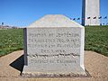
West side of Jefferson Pier with Washington Monument in background (April 2011)
-
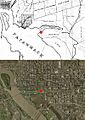
Location of Jefferson Pier on 1800 map (top) and modern satellite image (bottom).
-
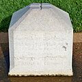
West side of the Jefferson Pier, showing crossed longitudinal and latitudinal lines on top of the monument (September 2009)
-
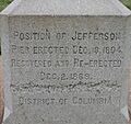
Inscription on west side of Jefferson Pier
