
John Senex facts for kids
John Senex (born in 1678 in Ludlow, Shropshire, died in 1740 in London) was a talented English mapmaker, engraver, and explorer. He also worked as an astrologer, geologist, and geographer for Queen Anne. Senex was known for editing and selling old maps. Most importantly, he created handy pocket-sized maps of the world. He ran his map business on Fleet Street in London.
Contents
Why John Senex Was Important
John Senex was one of the most important mapmakers of the 1700s. He began learning his trade in 1692. This was when he started an apprenticeship with Robert Clavell at the Stationers Company.
Famous World Maps
Senex is well-known for his detailed maps of the world. Some of these maps even showed elevations, like mountains and hills. They also featured tiny, detailed engravings. You can find many of his maps in museums today. For example, some are at the National Maritime Museum. Others are kept at Trinity College Dublin.
Working with Others
Senex worked with Charles Price on many projects. Together, they created a series of engravings for the London Almanacs. In 1714, he published an English Atlas with Maxwell. He also published a smaller version of Britannia by John Ogilby in 1719.
California as an Island
Senex became very interested in showing California as an island. Many of his maps show it this way. This unique feature makes his maps very popular with collectors. In 1721, he published a new general atlas. He was inspired by the work of another mapmaker, Guillaume de L’Isle.
Mapping the Stars
In the 1720s, Senex created many star charts. He worked with Edmond Halley on these projects. They used Halley's version of John Flamsteed's star catalogue.
Joining the Royal Society
In 1728, John Senex was chosen to join the Fellowship of the Royal Society of London. This was a great honor for his work in science and mapping.
Gallery
-
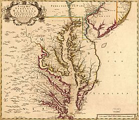
A new map of Virginia, Maryland and the improved parts of Pennsylvania & New Jersey, 1719
-
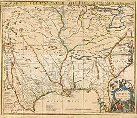
A map of Louisiana and the Mississippi River by John Senex (1721)
-
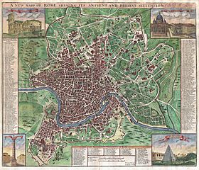
A map of Rome by Senex (1721)
.jpg)


See also
