Jumpinpin Channel facts for kids
The Jumpinpin channel, often called The Pin, is a waterway found between North Stradbroke Island and South Stradbroke Island. It has strong, fast-moving tides and deep water. Because of these strong currents, it's not a safe place for swimming. However, it's a very popular spot for people who enjoy fishing from the beach.
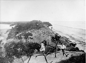
The name Jumpinpin comes from the Yugambeh language, which is the language of the local Aboriginal people. It means "Pandanus root."
The water near the ocean entrance of The Pin is quite shallow for about a kilometre. This means that if you want to cross this area safely, you need to know the local conditions very well.
The area around The Pin is always changing. Sand is constantly being moved by ocean currents and deposited in new places. For example, the entrance to Swan Bay recently moved several hundred metres towards the ocean, creating a whole new area for boats.
As mentioned, this area isn't really good for swimming because of the big tides and fast currents. Inland from the ocean entrance, The Pin has many mangroves and mud banks. These areas are also always changing, being built up and then washed away by the water. In recent years, some smaller islands like Rat Island, The Mud Clump, and Squire Island have completely disappeared.
How The Pin Formed
A channel might have formed and then filled up with sand many times in this area over thousands of years. However, the most recent time The Pin channel formed was mainly due to two big events.
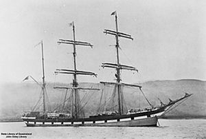
The first event was the wreck of a ship called the Cambus Wallace. This was a large steel sailing ship, about 75 metres long. Early in the morning of September 3, 1894, the Cambus Wallace got stuck in rough seas near a very narrow part of Stradbroke Island called Tuleen. Most of the sailors managed to swim to shore, but six men sadly drowned. They were buried on the beach.
The ship broke apart where it hit the land. Much of its cargo washed ashore, and local people collected it. During the cleanup, some explosives from the ship's cargo were gathered and purposely set off on the beach. This created large holes in the sand. People believe this explosion badly damaged the beach and made the sand dunes, which didn't have many plants holding them together, much weaker.
After this, the ocean side of the island slowly wore away over the next two years. The second event that finally created the channel at Jumpinpin was a powerful cyclone that hit in 1896. A writer named Thomas Welsby noted that the strong southeast gales and waves hit the exact spot where the Cambus Wallace had crashed. The waves were so powerful that they broke through the sandy land and created a passage into Swan Bay. Newspaper reports confirm that the channel was fully open by 1898. One report said, "News has now been received that the action of the recent gales on the coast, coupled with the abnormally high tides... has effected a clean breach through the island, and there is now a deep channel about half a mile wide at Jumping Pin."
The opening of The Pin caused big changes to the tides in the area around the Logan River. Farm land was eroded, and some farmers even had to build canals to protect their land. The oyster farming industry in the area was also affected because the changes in water density made it harder for oysters to grow on the seafloor.
Fishing at The Pin
The 'Pin is very famous for its excellent fishing. People catch huge amounts of fish here, especially during certain seasons. Some of the common fish caught include Bream, Flathead, Whiting, Luderick, Tailor, and Trevally. Many large Mulloway fish have also been caught in this area.
A few kilometres west of the ocean entrance, there's a spot known as Lew's Folly. This area is known for producing many bream and flathead when they are in season.
Other popular spots for catching bream and flathead are Whalley's Gutter, Tiger Mullet Channel, and Tree Gone Bay. You can usually only reach these places by boat. However, you can drive a 4WD vehicle to the southern tip of North Stradbroke Island, but the fishing from the beach there is not as good.
 | Delilah Pierce |
 | Gordon Parks |
 | Augusta Savage |
 | Charles Ethan Porter |


