
Kahaluʻu Taro Loʻi facts for kids
Quick facts for kids |
|
|
Kahaluʻu Taro Loʻi Historic District
|
|

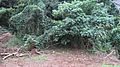
Terrace walls overgrown by hau trees
|
|

Location in Hawaii
|
|
| Nearest city | W of western end of Hui Kelu St., Kāneʻohe, Hawaiʻi |
|---|---|
| Area | 22 acres (8.9 ha) |
| NRHP reference No. | 73000669 |
| Added to NRHP | March 14, 1973 |
The Kahaluʻu Taro Loʻi Historic District is a special place in Kahaluʻu, on the side of Oʻahu that faces the wind. It's also called the ʻĀhuimanu Taro Complex. This area has the biggest and most complete system of terraces ever built for growing wetland taro on Oʻahu.
Taro is a plant with a starchy root that was a very important food for ancient Hawaiians. The district has at least 18 loʻi, which are special pond-like fields. These fields were once watered by the ʻĀhuimanu Stream. They also used ʻauwai, which are irrigation ditches, to bring water from the stream's starting point near the Koʻolau Range cliffs. This amazing system covers about 25 acres.
In 1973, this historic district was added to the National Register of Historic Places. This happened because people living nearby were worried about new buildings being planned for the area. The Kahaluu Fish Pond was also added to the National Register at the same time.
Contents
Ancient Hawaiian Farming: Taro Terraces
The loʻi terraces are shaped like rectangles. They are usually about 5 meters wide and 10 meters long. The front walls of these terraces are made of stacked stones. Some of these walls are 2 meters tall or even more!
Over time, these pondfields have filled up with silt (fine dirt). They are often hidden by lots of hau, mango, and guava trees. Even so, these terraces have survived many years of heavy rain on steep hillsides. They show us how skilled ancient Hawaiians were at managing water and preventing floods.
Studying the Terraces
In 1973, students from the University of Hawaiʻi studied the soil in the terraces. They were part of an archaeology program. The site was also cleared in the 1980s.
Today, the State of Hawaiʻi Historic Preservation Division wants to bring the site back to life. They are looking for groups in the community to help clear the area. The goal is to make these ancient taro fields work again.
Visiting the Historic District
The land where the historic district is located belongs to Temple Valley Corp. This company has continued to build new houses around the area.
When the district was first added to the National Register, it was described as being about 900 meters west of Hui Kelu Street. You could reach it by an old jeep road. Even in 1996, a hiker mentioned using this jeep road.
However, Hui Kelu Street has since been extended. It now crosses the ʻĀhuimanu Stream, which is where a hiking trail starts. The lower part of the old jeep road is now called Heno Place.
Gallery
-
The ʻĀhuimanu Stream with a fence and tunnel near Hui Kelu Street.
-
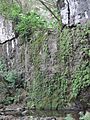
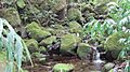
A dry waterfall area at the stream's starting point.
-
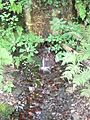
A spring and an old water pipe at the stream's source.
-
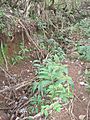
An old ʻauwai (irrigation ditch) above the stream.
-
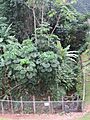
The overgrown start of a trail at ʻĀhuimanu Stream and Hui Kelu Street.
-
Crossing the ʻĀhuimanu Stream.
-

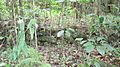
A low terrace wall.
-
A low terrace wall surrounded by young trees called saplings.


