Kasaan, Alaska facts for kids
Quick facts for kids
Kasaan
Gasa'áan / Kasa'aan
|
|
|---|---|

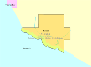
Detailed map of Kasaan
|
|
| Country | United States |
| State | Alaska |
| Incorporated | 1976 |
| Area | |
| • Total | 6.80 sq mi (17.61 km2) |
| • Land | 6.06 sq mi (15.70 km2) |
| • Water | 0.73 sq mi (1.90 km2) |
| Elevation | 13 ft (4 m) |
| Population
(2020)
|
|
| • Total | 30 |
| • Density | 4.95/sq mi (1.91/km2) |
| Time zone | UTC-9 (Alaska (AKST)) |
| • Summer (DST) | UTC-8 (AKDT) |
| ZIP code |
99950
|
| Area code | 907 |
| FIPS code | 02-37650 |
| GNIS feature ID | 1404468 |
Kasaan (pronounced kə-SAN) is a small city in Alaska, a U.S. state. It is located in the Prince of Wales-Hyder Census Area. The name "Kasaan" comes from the Tlingit word Kasa'aan, which means "pretty town". In 2020, 30 people lived there.
Contents
History of Kasaan
Kasaan is an important historical village for the Kaigani Haida people. It is the northernmost Haida settlement. The Haida people established it a very long time ago. They moved there from Haida Gwaii (an island group in Canada) to Dall Island and Prince of Wales Island in Alaska.
Early Trade and Challenges
Starting in the late 1700s, ships from Europe and the United States began visiting Kasaan. They came to trade for furs. This trade brought new goods and wealth to the Haida. However, it also brought diseases. A serious illness arrived in Kasaan in 1794.
Between 1836 and 1841, a fur trader named John Work counted 249 people in the village. Another widespread illness in 1862 greatly reduced the Haida population. By 1880, only 173 people lived in Kasaan. In the late 1800s, boats from the Alaska Steamship Company visited a nearby fish processing business. Tourists also came to Kasaan, which helped people trade Haida art and artifacts.
Moving to New Kasaan
The people of Kasaan began moving from their old village (now called Old Kasaan) in 1893. Most of them moved between 1902 and 1904. In 1901, a mining company convinced the village leaders to move the entire community. The new location was closer to a copper mine and a fish cannery. The company promised jobs and a school. Kasaan officially became a city in 1976.
Old Kasaan National Monument
The old village of Kasaan was completely empty by 1904. A fire partly destroyed the remains in 1915. In 1916, the site was named a national monument. It was called Old Kasaan National Monument. However, it was not well cared for, and plans to restore it were not completed.
In 1938, some historic totem poles were moved from Old Kasaan to the new Kasaan. In 1955, the site was no longer part of the National Park System. It then came under the care of the United States Forest Service. In 1957, they created the 38-acre Old Kasaan Village Historical Area. The moved totem poles and a relocated house in New Kasaan are now part of the Chief Son-I-Hat's Whale House and Totems Historic District. This area was recognized as historic in 2002.
Geography of Kasaan
Kasaan is located at 55°32′30″N 132°24′7″W. The city covers about 6.2 square miles (16.1 square kilometers). Most of this area, about 5.3 square miles (13.7 square kilometers), is land. The rest, about 0.9 square miles (2.3 square kilometers), is water. As mentioned before, Kasaan means "pretty town" in the Tlingit language.
Population Changes
| Historical population | |||
|---|---|---|---|
| Census | Pop. | %± | |
| 1910 | 129 | — | |
| 1920 | 126 | −2.3% | |
| 1930 | 112 | −11.1% | |
| 1940 | 85 | −24.1% | |
| 1950 | 47 | −44.7% | |
| 1960 | 36 | −23.4% | |
| 1970 | 30 | −16.7% | |
| 1980 | 25 | −16.7% | |
| 1990 | 54 | 116.0% | |
| 2000 | 39 | −27.8% | |
| 2010 | 49 | 25.6% | |
| 2020 | 30 | −38.8% | |
| U.S. Decennial Census | |||
Kasaan first appeared in the U.S. Census in 1910. At that time, it was an unincorporated native village. It became an official city in 1976.
In the year 2000, Kasaan had 39 people living in 17 households. Most residents were White or Native American. The average household had about 2.3 people. The median age of the population was 45 years old.
Education in Kasaan
Students in Kasaan attend the Barry Craig Stewart Kasaan School. This school is part of the Southeast Island School District.
See also
 In Spanish: Kasaan (Alaska) para niños
 | Bessie Coleman |
 | Spann Watson |
 | Jill E. Brown |
 | Sherman W. White |


