Katarapko, South Australia facts for kids
Quick facts for kids KatarapkoSouth Australia |
|||||||||||||||
|---|---|---|---|---|---|---|---|---|---|---|---|---|---|---|---|

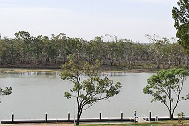
Katarapko as viewed from Loxton.
|
|||||||||||||||
| Established | 12 August 1999 | ||||||||||||||
| Postcode(s) | 5343 | ||||||||||||||
| Time zone | ACST (UTC+9:30) | ||||||||||||||
| • Summer (DST) | ACST (UTC+10:30) | ||||||||||||||
| Location |
|
||||||||||||||
| LGA(s) | Berri Barmera Council | ||||||||||||||
| County | Hamley | ||||||||||||||
| State electorate(s) | Chaffey | ||||||||||||||
| Federal Division(s) | Barker | ||||||||||||||
|
|||||||||||||||
|
|||||||||||||||
| Footnotes | Distances Adjoining localities |
||||||||||||||
Katarapko is a special place in South Australia, located in an area called the Riverland. It's about 188 kilometers (117 miles) north-east of Adelaide, the state capital. You can find it about 6.6 kilometers (4.1 miles) north of a town called Loxton.
History of Katarapko
During World War II, Katarapko Island was home to a prisoner camp. This camp, known as the Katarapko Wood Camp, was one of three smaller camps linked to a main camp complex at Loveday. These camps were used during the war.
Where is Katarapko?
Katarapko's official boundaries were set up in 1999. Its name comes from Katarapko Island, which is a big part of the area. The place includes all of Katarapko Island and some land to its west.
Natural Boundaries
The area is mostly surrounded by natural waterways. These include the Katarapko Creek and the Murray River. Only parts of its western and northern sides are not bordered by water. In 2014, the southern boundary was changed. This was done to make sure all of Kapunda Island was part of the rural area of Loxton.
What is Katarapko like today?
Most of the land within Katarapko is set aside for conservation. This means it's protected to keep its natural environment safe. The entire area is part of the Katarapko section of the Murray River National Park. This park helps protect the unique plants and animals of the region.
Population Information
According to the 2016 Australian census, which happened in August 2016, Katarapko had a population of zero. This means no one lives there permanently, as it is mainly a national park.
How Katarapko is Governed
Katarapko is part of several government areas. It is located within the federal division of Barker. For state government, it's in the electoral district of Chaffey. Locally, it is managed by the Berri Barmera Council. These groups help make decisions about the area.
 | Lonnie Johnson |
 | Granville Woods |
 | Lewis Howard Latimer |
 | James West |


