Kayak Island facts for kids
|
Bering Expedition Landing Site
(Eyak: Qe'yiłteh) |
|
| Location | Katalla, Alaska |
|---|---|
| Built | 1741 |
| NRHP reference No. | 77001542 |
Quick facts for kids Significant dates |
|
| Added to NRHP | July 20, 1977 |
| Designated NHL | June 2, 1978 |
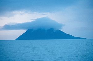
Kayak Island is a small island in the Gulf of Alaska. Its name in the Eyak language is Qe'yiłteh. The island is about 100 kilometers (62 miles) southeast of Cordova, Alaska. It is part of the Chugach National Forest area. Kayak Island covers about 73.7 square kilometers (28.5 square miles) and has no people living on it.
The island is also home to the Bering Expedition Landing Site. This site is very important in history. It marks some of the first times Europeans met with native people in Alaska.
Contents
About Kayak Island
How Kayak Island Got Its Name
The island was named "Kayak" in 1826. A Russian Navy officer, Lt. Sarichef, gave it this name. He thought the island's shape looked like an Inuit skin canoe, which is called a kayak.
Another name for the island was given by Spanish explorers. In 1779, an expedition led by Ignacio de Arteaga y Bazán saw the island. They named it "Nuestra Senora del Carmen" or "Isla del Carmen." This was because they saw it on July 16, a special day for "Our Lady of Mt. Carmel."
Early European Explorers
Kayak Island played a big role in early explorations of Alaska. It was a place where European explorers first tried to connect with the native people.
Captain Cook's Visit
Captain James Cook visited Kayak Island on May 12, 1778. He buried a bottle there. Inside the bottle was a paper and two small silver pieces. These were given to him by Dr. Richard Kaye, a chaplain for King George III.
Bering Expedition Landing Site
The Bering Expedition Landing Site is a very important historical spot on the island. It was made a National Historic Landmark in 1978. This means it is a place recognized for its special history in the United States.
Important Landmarks
Cape Saint Elias
Cape Saint Elias is found on the southwest side of Kayak Island. This cape likely gave its name to Mount Saint Elias. Mount Saint Elias is a huge mountain about 185 kilometers (115 miles) to the east-northeast. It is the second-highest mountain in both the United States and Canada.
Alaska's First Tornado
Cape Saint Elias is also known for a rare event. On November 4, 1959, Alaska's first confirmed tornado happened there. It caused only minor damage to the area. Alaska was the last state to record its first tornado since 1950.
Cape St. Elias Light
The Cape St. Elias Light is an important lighthouse on the island. It helps ships navigate safely in the area.
See also
 In Spanish: Isla Kayak para niños
 | Aaron Henry |
 | T. R. M. Howard |
 | Jesse Jackson |


