Kennedy County facts for kids
Quick facts for kids KennedyNew South Wales |
|||||||||||||||
|---|---|---|---|---|---|---|---|---|---|---|---|---|---|---|---|

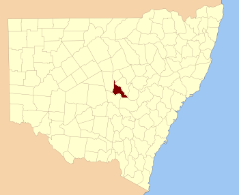
Location in New South Wales
|
|||||||||||||||
|
|||||||||||||||
Kennedy County is a special type of land division in New South Wales, Australia. It's like a big, imaginary section of land used for official records. You can find it west of the Bogan River, near the towns of Tottenham and Tullamore. This county was named after a famous explorer, Edmund Besley Court Kennedy, who lived from 1818 to 1848.
Exploring Kennedy County
Kennedy County is one of 141 such land areas in New South Wales. These areas are called cadastral divisions. They help the government keep track of land ownership and boundaries.
Who Was Edmund Kennedy?
The county gets its name from Edmund Besley Court Kennedy. He was an important explorer in Australia. He helped map out parts of the country. Naming places after explorers is a common way to remember their contributions.
Parishes in Kennedy County
Inside Kennedy County, there are smaller areas called parishes. These parishes are also used for land records. Each parish belongs to a Local Government Area (LGA). An LGA is like a local council that manages services for the community.
Below is a list of the parishes in Kennedy County. It also shows which LGA they are part of. You can also see their map coordinates. These coordinates help pinpoint their exact location on a map.
| Parish | LGA | Coordinates |
|---|---|---|
| Albert | Lachlan Shire | 32°24′54″S 147°30′04″E / 32.41500°S 147.50111°E |
| Babathnil | Lachlan Shire | 32°31′54″S 147°26′04″E / 32.53167°S 147.43444°E |
| Beaconsfield | Lachlan Shire | 32°14′54″S 147°21′04″E / 32.24833°S 147.35111°E |
| Belardery | Parkes Shire | 32°46′54″S 148°00′04″E / 32.78167°S 148.00111°E |
| Bentinck | Parkes Shire | 32°29′54″S 147°37′04″E / 32.49833°S 147.61778°E |
| Beugamel | Parkes Shire | 32°39′54″S 147°47′04″E / 32.66500°S 147.78444°E |
| Boona | Lachlan Shire | 32°37′54″S 147°12′04″E / 32.63167°S 147.20111°E |
| Braalghy | Lachlan Shire | 32°34′54″S 147°18′04″E / 32.58167°S 147.30111°E |
| Bulbodney | Lachlan Shire | 32°29′54″S 147°15′04″E / 32.49833°S 147.25111°E |
| Burdenda | Lachlan Shire | 32°01′54″S 147°20′04″E / 32.03167°S 147.33444°E |
| Burra | Lachlan Shire | 32°42′54″S 147°24′04″E / 32.71500°S 147.40111°E |
| Burrill | Parkes Shire | 32°48′54″S 148°13′04″E / 32.81500°S 148.21778°E |
| Carolina | Lachlan Shire | 32°09′54″S 147°26′04″E / 32.16500°S 147.43444°E |
| Cavendish | Lachlan Shire | 32°25′54″S 143°32′04″E / 32.43167°S 143.53444°E |
| Cookopie | Parkes Shire | 32°44′54″S 148°08′04″E / 32.74833°S 148.13444°E |
| Coradgery West | Parkes Shire | 32°52′54″S 147°52′04″E / 32.88167°S 147.86778°E |
| Coradgery | Parkes Shire | 32°48′54″S 148°00′04″E / 32.81500°S 148.00111°E |
| Dandaloo | Lachlan Shire | 32°14′54″S 147°30′04″E / 32.24833°S 147.50111°E |
| Davison | Parkes Shire | 32°59′54″S 148°11′04″E / 32.99833°S 148.18444°E |
| Derribong | Lachlan Shire | 32°19′54″S 147°38′04″E / 32.33167°S 147.63444°E |
| Euchabil | Parkes Shire | 32°40′54″S 147°52′04″E / 32.68167°S 147.86778°E |
| Fitzroy | Lachlan Shire | 32°40′54″S 147°28′04″E / 32.68167°S 147.46778°E |
| Genanaguy | Parkes Shire | 32°41′54″S 148°05′04″E / 32.69833°S 148.08444°E |
| Genaren | Parkes Shire | 32°34′54″S 147°49′04″E / 32.58167°S 147.81778°E |
| Gillenbine | Lachlan Shire | 32°43′54″S 147°29′04″E / 32.73167°S 147.48444°E |
| Gobondry | Parkes Shire | 32°45′54″S 147°34′04″E / 32.76500°S 147.56778°E |
| Graddle | Parkes Shire | 32°28′54″S 147°55′04″E / 32.48167°S 147.91778°E |
| Hartington | Lachlan Shire | 32°22′54″S 147°14′04″E / 32.38167°S 147.23444°E |
| Hastings | Parkes Shire | 32°24′54″S 147°39′04″E / 32.41500°S 147.65111°E |
| Hawarden | Lachlan Shire | 32°23′54″S 147°21′04″E / 32.39833°S 147.35111°E |
| Houston | Parkes Shire | 32°56′54″S 148°18′04″E / 32.94833°S 148.30111°E |
| Kadina | Parkes Shire | 32°52′54″S 148°18′04″E / 32.88167°S 148.30111°E |
| Limestone | Parkes Shire | 32°59′54″S 148°03′04″E / 32.99833°S 148.05111°E |
| Merilba | Bogan Shire | 32°00′54″S 147°15′04″E / 32.01500°S 147.25111°E |
| Meryula | Lachlan Shire | 32°14′54″S 147°16′04″E / 32.24833°S 147.26778°E |
| Mickibri | Parkes Shire | 32°52′54″S 148°11′04″E / 32.88167°S 148.18444°E |
| Mickimill | Lachlan Shire | 32°38′54″S 147°24′04″E / 32.64833°S 147.40111°E |
| Mingelo | Lachlan Shire | 32°07′54″S 147°15′04″E / 32.13167°S 147.25111°E |
| Mingerong | Parkes Shire | 32°41′54″S 148°00′04″E / 32.69833°S 148.00111°E |
| Moodana South | Lachlan Shire | 32°10′54″S 147°19′04″E / 32.18167°S 147.31778°E |
| Moodana | Lachlan Shire | 32°06′54″S 147°21′04″E / 32.11500°S 147.35111°E |
| Mungerie | Parkes Shire | 32°36′54″S 148°02′04″E / 32.61500°S 148.03444°E |
| Ormonde | Parkes Shire | 32°29′54″S 147°43′04″E / 32.49833°S 147.71778°E |
| Ossory | Parkes Shire | 32°26′54″S 147°44′04″E / 32.44833°S 147.73444°E |
| Redcliffe | Parkes Shire | 32°45′54″S 147°41′04″E / 32.76500°S 147.68444°E |
| Russell | Parkes Shire | 32°36′54″S 147°43′04″E / 32.61500°S 147.71778°E |
| Salisbury | Parkes Shire | 32°46′54″S 147°44′04″E / 32.78167°S 147.73444°E |
| Sarsfield | Lachlan Shire | 32°33′54″S 147°24′04″E / 32.56500°S 147.40111°E |
| Somerset | Lachlan Shire | 32°37′54″S 147°29′04″E / 32.63167°S 147.48444°E |
| Stanley | Parkes Shire | 32°37′54″S 147°37′04″E / 32.63167°S 147.61778°E |
| Strahorn | Parkes Shire | 32°35′54″S 147°56′04″E / 32.59833°S 147.93444°E |
| Tabratong | Lachlan Shire | 32°14′54″S 147°27′04″E / 32.24833°S 147.45111°E |
| Talingaboolba | Lachlan Shire | 32°32′54″S 147°02′04″E / 32.54833°S 147.03444°E |
| Tanilogo | Parkes Shire | 32°47′54″S 147°52′04″E / 32.79833°S 147.86778°E |
| Tout | Lachlan Shire | 32°43′54″S 147°25′04″E / 32.73167°S 147.41778°E |
| Wellwood | Parkes Shire | 32°27′54″S 147°38′04″E / 32.46500°S 147.63444°E |
| Weridgery | Parkes Shire | 32°59′54″S 148°02′04″E / 32.99833°S 148.03444°E |
| Willanbalang | Parkes Shire | 32°27′54″S 147°50′04″E / 32.46500°S 147.83444°E |
| Wilmatha | Lachlan Shire | 32°32′54″S 147°08′04″E / 32.54833°S 147.13444°E |
| Wombin | Parkes Shire | 32°50′54″S 148°03′04″E / 32.84833°S 148.05111°E |
| Yralla | Lachlan Shire | 32°29′54″S 147°32′04″E / 32.49833°S 147.53444°E |

