Oxley County facts for kids
Quick facts for kids OxleyNew South Wales |
|||||||||||||||
|---|---|---|---|---|---|---|---|---|---|---|---|---|---|---|---|

Location in New South Wales
|
|||||||||||||||
|
|||||||||||||||
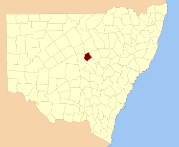
Oxley County, New South Wales is a special kind of land division in New South Wales, Australia. It's one of 141 such areas, used mainly for keeping track of land ownership and boundaries. Think of it like an old-fashioned way to divide up the land for maps and records.
This county is located in a part of New South Wales that's quite dry. It sits between two important rivers: the Bogan River to the west and the Macquarie River to the east. You can find it roughly between the towns of Warren and Nyngan.
Who Was Oxley?
Oxley County was named after a very important person in Australian history: John Joseph William Molesworth Oxley. He was born in 1785 and passed away in 1828.
Explorer and Surveyor
John Oxley was a Surveyor-General and an explorer. This means he was in charge of mapping out new areas of land. He played a big role in exploring and charting parts of New South Wales during the early 1800s. Naming a county after him was a way to honor his contributions to understanding the geography of Australia.
What Are Parishes?
Within Oxley County, like many other counties, there are smaller divisions called parishes. These are even tinier areas of land, also used for mapping and land records.
Local Government Areas
Each parish in Oxley County belongs to a Local Government Area (LGA). LGAs are like local councils that manage services for the people living in those areas. For example, some parishes in Oxley County are part of the Warren Shire, while others are in the Bogan Shire.

