Kennedy Lake (Vancouver Island) facts for kids
Quick facts for kids Kennedy Lake |
|
|---|---|
 |
|
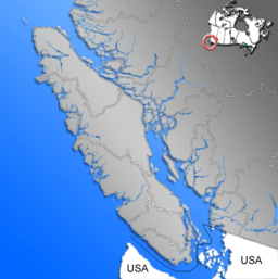
| Location | Vancouver Island, British Columbia |
| Coordinates | 49°3′N 125°33′W / 49.050°N 125.550°W |
| Primary inflows | Clayoquot River, Kennedy River, Sand River |
| Basin countries | Canada |
| Surface area | 6,475 ha (16,000 acres) |
| Average depth | 38 m (125 ft) |
| Max. depth | 145 m (476 ft) |
| Residence time | 1.1 year |
| Shore length1 | 111.9 km (69.5 mi) |
| Surface elevation | 12 m (39 ft) |
| 1 Shore length is not a well-defined measure. | |
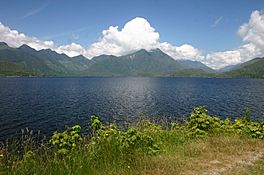
Kennedy Lake is the largest lake found on Vancouver Island, which is in British Columbia, Canada. This beautiful lake is located north of Ucluelet on the central west coast of the island. It mainly forms where the Clayoquot River and Kennedy River meet. The water then flows out through a short part of the Kennedy River into Tofino Inlet. The lake also has a long northern section called Clayoquot Arm.
Because of its amazing natural beauty, parts of Kennedy Lake and the area around it are protected. This helps keep them safe from the logging industry, which is active on the island. Several parks are located near the lake, including Clayoquot Plateau Provincial Park, Pacific Rim National Park, Clayoquot Arm Provincial Park, Kennedy Lake Provincial Park, and Kennedy River Bog Provincial Park. There's also a fun spot called the Clayoquot Arm Beach recreation site.
Kennedy Lake is a popular place for outdoor activities like camping, boating, and fishing. It's also a very important place for different types of salmon and trout to lay their eggs. The lake is part of the traditional lands of the Tla-o-qui-aht First Nations. It was named after Sir Arthur Kennedy, who was the last governor of the Colony of Vancouver Island.
Lake Size and Shape
Kennedy Lake covers a huge area of about 6,475 hectares. This makes it the biggest lake on Vancouver Island. It has a unique, irregular shape, almost like two separate bowls of water. These two main parts are called the Main Arm and the Clayoquot Arm. They are connected by a narrow, shallower area.
The average depth of the lake is about 38 meters (125 feet). However, the shallow part connecting the two arms is less than 10 meters (33 feet) deep. The deepest spot in the lake goes down to an amazing 145 meters (476 feet)! The lake itself sits about 12 meters (39 feet) above sea level.
Getting to Kennedy Lake
British Columbia Highway 4 runs along the southeast and southern sides of Kennedy Lake. This is the only highway that leads to the communities of Ucluelet and Tofino. So, if you want to visit these coastal towns, you'll likely drive right past this impressive lake!
 | Selma Burke |
 | Pauline Powell Burns |
 | Frederick J. Brown |
 | Robert Blackburn |


