Kenton, Delaware facts for kids
Quick facts for kids
Kenton, Delaware
|
|
|---|---|

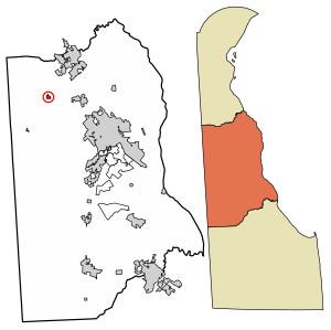
Location of Kenton in Kent County, Delaware.
|
|
| Country | |
| State | |
| County | Kent |
| Area | |
| • Total | 0.18 sq mi (0.46 km2) |
| • Land | 0.18 sq mi (0.46 km2) |
| • Water | 0.00 sq mi (0.00 km2) |
| Elevation | 59 ft (18 m) |
| Population
(2020)
|
|
| • Total | 215 |
| • Density | 1,221.59/sq mi (471.08/km2) |
| Time zone | UTC−5 (Eastern (EST)) |
| • Summer (DST) | UTC−4 (EDT) |
| ZIP code |
19955
|
| Area code(s) | 302 |
| FIPS code | 10-39100 |
| GNIS feature ID | 214191 |
Kenton is a small town located in Kent County, Delaware, United States. It is part of the larger Dover metropolitan area. In 2020, the town had a population of 215 people.
Contents
History of Kenton
Kenton started as a small community where two important roads met. These roads are now known as Delaware Route 42 and Delaware Route 300. The town began to grow in the late 1700s.
How Kenton Got Its Name
A man named Philip Lewis first planned the community in 1796. He had started buying land there a few years earlier. At first, the area was called Georgetown. Later, it was known as Lewis Crossroads. Finally, in 1806, it was officially named Kenton.
Historic Places in Kenton
The Kenton Historic District was added to the National Register of Historic Places in 1983. This means it's a special area recognized for its important historical buildings and sites. Many other historic places are also located in or near Kenton.
Geography of Kenton
Kenton is located at 39°13′39″N 75°39′47″W / 39.2276115°N 75.6629847°W.
What is Kenton's Size?
According to the United States Census Bureau, the town covers a total area of about 0.2 square miles (0.46 square kilometers). All of this area is land, with no water.
People of Kenton
| Historical population | |||
|---|---|---|---|
| Census | Pop. | %± | |
| 1880 | 107 | — | |
| 1890 | 241 | 125.2% | |
| 1900 | 192 | −20.3% | |
| 1910 | 209 | 8.9% | |
| 1920 | 212 | 1.4% | |
| 1930 | 175 | −17.5% | |
| 1940 | 233 | 33.1% | |
| 1950 | 211 | −9.4% | |
| 1960 | 249 | 18.0% | |
| 1970 | 205 | −17.7% | |
| 1980 | 243 | 18.5% | |
| 1990 | 232 | −4.5% | |
| 2000 | 237 | 2.2% | |
| 2010 | 261 | 10.1% | |
| 2020 | 215 | −17.6% | |
| U.S. Decennial Census | |||
In 2000, there were 237 people living in Kenton. These people lived in 83 different homes. Most of the people in Kenton were White (94.51%), with some African American (3.38%) and other races. About 4.64% of the population was Hispanic or Latino.
Age and Income in Kenton
The average age of people in Kenton in 2000 was 36 years old. About 27.8% of the population was under 18 years old. The average income for a household in Kenton was $38,250 per year.
Infrastructure in Kenton
Infrastructure refers to the basic facilities and systems that a town needs to function.
Transportation in Kenton
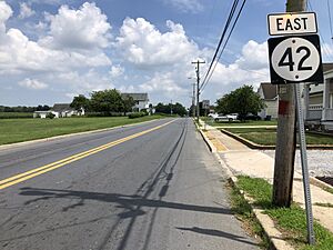
Kenton is located where two state roads meet: Delaware Route 42 and Delaware Route 300.
- DE 42 goes northwest towards Blackiston and east towards Cheswold. In Cheswold, you can connect to U.S. Route 13, which leads to the city of Dover.
- DE 300 goes southwest towards the Maryland border and northeast towards Smyrna. In Smyrna, it also connects to US 13, which can take you to Wilmington.
Utilities in Kenton
- Electricity: Delmarva Power provides electricity to the town.
- Natural Gas: Chesapeake Utilities supplies natural gas.
- Trash Collection: Several private companies, like Waste Industries and Waste Management, handle trash collection.
Education in Kenton
Children in Kenton attend schools within the Smyrna School District. The main high school for students in Kenton is Smyrna High School.
See also
 In Spanish: Kenton (Delaware) para niños
 | Aurelia Browder |
 | Nannie Helen Burroughs |
 | Michelle Alexander |


