Kentucky, New South Wales facts for kids
Quick facts for kids KentuckyNew South Wales |
|
|---|---|

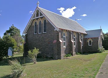
St Mark's Church, Kentucky
|
|
| Population | 158 (2016 census) |
| Postcode(s) | 2354 |
| Elevation | 1,066 m (3,497 ft) |
| Location | |
| LGA(s) | Uralla Shire |
| County | Sandon |
| State electorate(s) | Northern Tablelands |
| Federal Division(s) | New England |
Kentucky is a small village in the New England region of New South Wales, Australia. It sits high up on the Northern Tablelands, about 1066 meters (3,497 feet) above sea level.
The village is located about 17 kilometers (11 miles) south of Uralla. It is also about 35 kilometers (22 miles) north-west of Walcha. Kentucky is part of the Uralla Shire local government area. In 2016, about 158 people lived in Kentucky.
Contents
Exploring Kentucky's Past
Early Events and the Railway
On May 25, 1870, a famous event happened near Kentucky Creek. A rural lock-up keeper named Alexander Binning Walker confronted and stopped the well-known bushranger Fred Ward. Fred Ward was also known as Captain Thunderbolt.
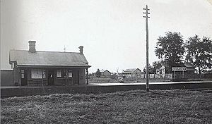
The Kentucky railway station opened on August 2, 1882. It was part of the Main North Line. The station closed many years ago. However, trains still travel through the village every day, connecting Sydney and Armidale.
| Preceding station | Former Services | Following station | ||
|---|---|---|---|---|
| Uralla
towards Wallangarra
|
Main North Line | Wollun
towards Sydney
|
||
Soldier Settlement History
The area around Kentucky was once a special place for soldiers who returned from war. This was called a soldier settlement region. Many orchards and farms were set up here.
The Kentucky Returned Soldiers Settlement began in July 1918. It was located along the railway line between Kentucky and Wollun. This settlement covered a large area of about 7,319 acres (2,962 hectares). The land was divided into eighty farms. These farms ranged from 40 to 250 acres (16 to 101 hectares) in size.
About 1,200 acres (486 hectares) of the land was used for orchards. Farmers grew apples, pears, prunes, plums, and cherries.
Honoring Local Heroes
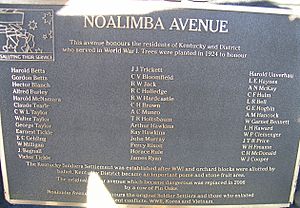
In 2008, the Kentucky Memorial Hall added a special plaque. This plaque is at the Noalimba Avenue of Honour. It remembers the first soldier settlers. It also honors all the servicemen and women from the area who joined later conflicts.
About 4 kilometers (2.5 miles) south of Kentucky is Kentucky South. This was a railway siding that opened in 1926 and closed in 1975. Some old rail sheds and houses can still be seen there today.
Kentucky Today: A Modern Village
Farming and Local Businesses
Today, the Kentucky district is known for its farming. It has several well-known Merino sheep farms. These farms produce very fine wool. The area also raises high-quality beef cattle.
If you visit during the right season, you can find fresh apples, cherries, pears, and other stone fruits from local orchards. The Kentucky Tree Nursery sells many affordable trees and shrubs for planting on farms.
New and Exciting Places
Since 2009, some new businesses have opened just north-east of the village. These include Dobson's, a special distillery and brewery. There's also Pinot, a fancy restaurant, and The Speakeasy, a cool nightclub. Together, these places are called Eastview Estate.
Community Life
Kentucky also has two churches and a community hall. There is a general store for everyday needs. The local public school is always improving. Sometimes, people can visit some of the beautiful country gardens through special open garden events. These events often help raise money for the community. The current population of Kentucky is about 60 people.
 | William M. Jackson |
 | Juan E. Gilbert |
 | Neil deGrasse Tyson |


