Ki-a-Kuts Falls facts for kids
Quick facts for kids Ki-a-Kuts Falls |
|
|---|---|

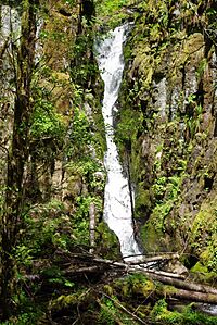
Ki-a-Kuts Falls in late spring
|
|
| Lua error in Module:Infobox_mapframe at line 185: attempt to index field 'wikibase' (a nil value). | |
| Location | Washington County, Oregon, United States |
| Coordinates | 45°27′59″N 123°23′16″W / 45.4665°N 123.387890°W |
| Type | Cascade |
| Elevation | 1,299 ft (396 m) |
| Total height | 40 ft (12 m) |
| Number of drops | 1 |
| Watercourse | Tualatin River |
Ki-a-Kuts Falls is a beautiful 40-foot (12 m) tall waterfall located on the Tualatin River. You can find it in Washington County, Oregon, in the United States. This waterfall was first found in 1993 in a quiet, hard-to-reach part of the river.
The falls were named to honor Chief Ki-a-Kuts. He was the last chief of the local Native American group called the Atfalati. The water at Ki-a-Kuts Falls drops in a single stream. It flows down a narrow path in the basalt cliffs that hang over the river.
Discovering the Falls
In July 1993, a group of eight explorers from the Tualatin Riverkeepers organization went on an adventure. They were exploring the upper parts of the Tualatin River. This river is the only one in Washington County.
During their hike, the group unexpectedly found the waterfall. It was not on any maps at that time. They found it while walking in the river, about 1.5 miles (2.4 km) north of Barney Reservoir.
After their discovery, the group worked hard. They wanted the waterfall to be added to official maps. They also wanted it to get an official name. The United States Board on Geographic Names and the state naming board helped with this.
Early ideas for the name included Lost Falls or Riverkeepers Falls. However, the group decided to honor the Native American people who lived in the Tualatin Valley long ago. The state naming board officially accepted the name on June 10, 1999.
Honoring Chief Ki-a-Kuts
On June 21, 1999, a special ceremony took place. The waterfall was officially named Ki-a-Kuts Falls. Leaders from the Confederated Tribes of the Grand Ronde attended the event.
The falls were named after the last chief of the Atfalati. The Atfalati were a group of Native Americans. They were part of the Kalapuya language family. These people lived in the Tualatin Valley before European settlers arrived.
Sadly, many Atfalati people became sick and died in the early 1800s. This was due to diseases brought by new settlers. The few who survived were forced to leave their homes. They were moved to the Grand Ronde Indian Reservation. This reservation is in what is now Polk County. Other Native American groups also moved there.
What the Falls Look Like
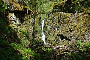
Ki-a-Kuts Falls is 40 feet (12 m) tall. The water rushes down a narrow rock channel. It forms a single cascade over dark basalt cliffs. At the bottom, the water lands in a pool.
Trees often block the full view of the falls. Also, a bend in the river helps keep the falls hidden. This is why they were not noticed by modern explorers for so long. They were also missing from maps.
The falls are located about 1,700 feet (520 m) upriver (to the west). This is from where the Tualatin River meets Maple Creek. They are also about 1.4 miles (2.3 km) north of Barney Reservoir. The elevation of the falls is 1,299 feet (396 m).
This area is west of Henry Hagg Lake and the city of Gaston. It is also about 3.5 miles (5.6 km) east of the border with Tillamook County. The falls are inside the Tillamook State Forest.
Usually, the Board of Geographic Names does not accept place names with hyphens. However, they made an exception for Ki-a-Kuts Falls. This was because the request was to honor a Native American chief. Also, the Confederated Tribes of the Grand Ronde asked for the last word to be spelled with a "K" instead of a "C."
 | Valerie Thomas |
 | Frederick McKinley Jones |
 | George Edward Alcorn Jr. |
 | Thomas Mensah |


