
Kia Ora, Queensland facts for kids
Quick facts for kids Kia OraQueensland |
|||||||||||||||
|---|---|---|---|---|---|---|---|---|---|---|---|---|---|---|---|

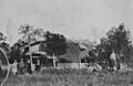
Kia-Ora State School, 2020
|
|||||||||||||||

Kia Ora
Location in Queensland
|
|||||||||||||||
| Postcode(s) | 4570 | ||||||||||||||
| Area | 22.5 km2 (8.7 sq mi) | ||||||||||||||
| Time zone | AEST (UTC+10:00) | ||||||||||||||
| Location |
|
||||||||||||||
| LGA(s) | Gympie Region | ||||||||||||||
| State electorate(s) | Gympie | ||||||||||||||
| Federal Division(s) | Wide Bay | ||||||||||||||
|
|||||||||||||||
Kia Ora is a small, quiet area in Queensland, Australia. It's a rural locality in the Gympie Region. In 2021, about 218 people lived here. It's a place where you can find open spaces and a friendly community.
Contents
A Look Back in Time
The name Kia Ora comes from a large farm owned by the Elliott family. The name itself is a Māori greeting, meaning "hello" or "be well."
A school called Kia-Ora Provisional School first opened on July 18, 1921. The Elliott family generously gave the land for the school. It became a state school in 1927.
In 1931, the main jobs in Kia Ora were dairying (farming cows for milk) and forestry (working with trees and wood).
A church, the Kia Ora Methodist Church, opened in September 1938. Later, in 1977, it became a Uniting Church. The church building was eventually sold around 1990 and turned into a house.
On December 9, 1950, the Kia Ora Memorial Hall was built. This hall was created to honor people from the area who served in wars.
Who Lives in Kia Ora?
In 2021, the population of Kia Ora was 218 people. This number helps us understand how many people call this area home.
Learning in Kia Ora
Kia-Ora State School is a government primary school. It teaches students from Prep (the first year of school) up to Year 6. Both boys and girls attend this school. In 2017, there were 62 students enrolled. The school had 4 teachers and 11 other staff members helping out.
There isn't a high school directly in Kia Ora. Students who want to continue their education after primary school usually go to nearby towns. The closest government high schools are Gympie State High School in Gympie (for students up to Year 12) and Tin Can Bay State School in Tin Can Bay (for students up to Year 10).
Community Places
The Kia Ora Public Memorial Hall is an important community building. It's a place where people can gather for events and activities.
Images for kids
-
Kia Ora Station homestead in 1931

