Tin Can Bay, Queensland facts for kids
Quick facts for kids Tin Can BayQueensland |
|||||||||||||||
|---|---|---|---|---|---|---|---|---|---|---|---|---|---|---|---|

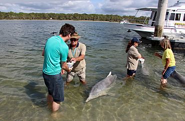
Dolphin Feeding at Tin Can Bay
|
|||||||||||||||
| Population | 2,293 (2021 census) | ||||||||||||||
| • Density | 8.749/km2 (22.66/sq mi) | ||||||||||||||
| Postcode(s) | 4580 | ||||||||||||||
| Elevation | 8 m (26 ft) | ||||||||||||||
| Area | 262.1 km2 (101.2 sq mi) | ||||||||||||||
| Time zone | AEST (UTC+10:00) | ||||||||||||||
| Location |
|
||||||||||||||
| LGA(s) |
|
||||||||||||||
| State electorate(s) | Gympie | ||||||||||||||
| Federal Division(s) | Wide Bay | ||||||||||||||
|
|||||||||||||||
Tin Can Bay is a lovely coastal town in Queensland, Australia. It's part of the Wide Bay–Burnett region. The town is known for its beautiful waters and friendly wild dolphins.
Tin Can Bay is split between two local government areas. The northern part is in the Fraser Coast Region. The southern part, where the main town is, belongs to the Gympie Region. In 2021, about 2,293 people lived in Tin Can Bay.
Contents
What is Tin Can Bay Like?
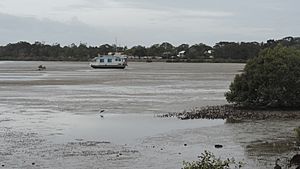
Tin Can Bay is located right next to the Great Sandy Strait. This strait is a waterway that separates mainland Queensland from Fraser Island. The area around Tin Can Bay is very important for nature. It's a special wetland called a Ramsar Convention site. This means it's recognized internationally for its importance. It's also an Important Bird Area of Australia. This makes it a great spot for bird watching.
The town itself sits on a small piece of land that sticks out into the water. It's located between Snapper Creek and the Great Sandy Strait.
A Look Back: Tin Can Bay's History
European settlers first came to Tin Can Bay in the 1870s. At that time, it was a place where logs were floated down the river to timber mills. These mills were located in Maryborough.
Later, Tin Can Bay became a very important fishing port. It still is today! Fishermen mainly catch prawns here. It's also a popular spot for people who enjoy fishing for fun.
How Tin Can Bay Got Its Name
The town was first called Wallu. But in 1937, its name was officially changed to Tin Can Bay. No one is completely sure where the name "Tin Can" came from. It's thought to come from an Indigenous name. One idea is tinchin, which means mangrove in the Yugarabul dialect. Another idea is tinken, meaning vine with large ribbed leaves. This comes from the Kabi language.
Schools and Libraries
Wallu State School first opened its doors on February 1, 1934. The school building was moved from the Wolvi area. On April 21, 1937, the school's name changed to Tin Can Bay State School. This change happened to match the town's new name.
The Tin Can Bay Library opened in 1985. It was updated and made much nicer in 2005.
Who Lives in Tin Can Bay?
The number of people living in Tin Can Bay has grown over the years.
- In 2011, about 1,994 people lived here.
- By 2016, the population grew to 2,242 people.
- In the most recent count in 2021, Tin Can Bay had 2,293 residents.
Special Places: Heritage Listings
Tin Can Bay has several places that are important to its history. These are called heritage-listed sites. They include:
- The Tin Can Bay Picnic Shelter on Cod Street.
- The Tin Can Bay Memorial Hall on Gympie Road.
- The Tin Can Bay Church at 22–24 Gympie Road.
- The Wide Bay Military Reserve on Tin Can Bay Road.
Learning in Tin Can Bay
Tin Can Bay State School is a school for both primary and secondary students. It teaches children from Prep (the first year of school) up to Year 10. The school is located at 2 Schnapper Creek Road. In 2018, there were 271 students. The school also has a special program for students who need extra support.
For students who want to continue their schooling up to Year 12, the closest government high school is Gympie State High School. This school is located in Gympie, which is to the south-west of Tin Can Bay.
Things to Do in Tin Can Bay
The Gympie Regional Council runs a public library in a park on Tin Can Bay Road. It's a great place to find books and learn new things.
The Tin Can Bay branch of the Queensland Country Women's Association meets at 18 Whiting Street. This group helps women in rural areas.
If you like sports, you can visit the Tin Can Bay Country Club at 222 Tin Can Bay Road. There's also the Cooloola Coast Bowls Club at 4463 Gympie Road.
There are also places where boats can get into the water. These are called boat ramps:
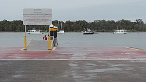
- The Norman Point boat ramp is managed by the Transport and Main Roads.
- Another boat ramp is on Toolara Road, near Teewah Creek. The Gympie Regional Council manages this one.
Fun Things to See and Do
Tin Can Bay is a very popular place for holidays. There are hotels, holiday apartments, and caravan parks where people can stay. You can also rent houseboats or yachts to explore the water. The town has a marina for boats.
For active fun, there's an 18-hole golf course. You can also play at two bowls clubs or on tennis courts. There's even an outdoor swimming pool!
One of the most exciting things to do is see the wild Australian humpback dolphins. They usually come to the Norman Point boat ramp early in the mornings. You can even hand-feed these dolphins under careful supervision! Bird watching is another popular activity. Tin Can Bay is home to many different kinds of birds.
Events and Festivals
Every September, Tin Can Bay hosts the Tin Can Bay Seafood Festival. It's a day full of fun for families. There's entertainment, funny competitions like mullet throwing, and prawn eating contests. You can even take helicopter rides over the bay! Plus, there are many stalls selling seafood and other market goods.
Other events throughout the year include:
- The Bay to Bay Yacht Race, where sailboats compete.
- The Dragonboat Regatta, a race with long, narrow boats.
- The Cooloola Coast Flower Show, displaying beautiful flowers.
- The Foreshore Family Carnival, which runs from Boxing Day to New Year's Eve.
 | Aurelia Browder |
 | Nannie Helen Burroughs |
 | Michelle Alexander |


