King John's Palace facts for kids
Quick facts for kids King John's Palace |
|
|---|---|
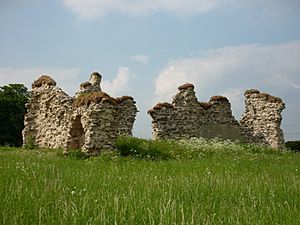
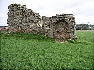
King John's Palace viewed from the south-east
|
|
| Location | King's Clipstone, Nottinghamshire, United Kingdom |
| Lua error in Module:Location_map at line 420: attempt to index field 'wikibase' (a nil value). | |
King John's Palace is what's left of an old royal home from the Middle Ages. It's located in Clipstone, in north-west Nottinghamshire, England. Even though it's called "King John's Palace" today, this name only started being used in the 1700s. Before that, people called it the "King's Houses." It's a bit of a mystery why it's linked to King John, because he only stayed there for a total of nine days!
The first time the King's Houses were mentioned was in 1164, when King Henry II was ruling (1154–1189). A lot of building work happened between 1176 and 1180. King Henry spent a lot of money, about £500, to improve the place. He also created a special deer park at Clipstone. Hunting deer was a popular activity for kings and nobles. These parks were used for fun, to get food for big feasts, and even for important political meetings. For example, in 1194, King Richard I met with William, King of Scots at Clipstone. Later, in 1290, King Edward I held a special meeting called Parliament there.
The King's Houses were once a very grand place. What you can see today are the ruins of a stone room built around 1180. This room had a big entrance with strong supports. It also had a wooden upper floor with fancy windows that looked out over the deer park. But this room was just a small part of a much bigger group of buildings. Old documents and archaeological digs show that there was a gatehouse, a tower, separate rooms for the King and Queen, several chapels, kitchens, stables for 200 horses, and places for many royal helpers to stay. There was even a large pond that provided lots of fish, like pike and roach, for royal meals.
Clipstone stayed an important royal spot until the late 1400s. Around this time, English kings and queens started to prefer other homes. By 1525, people were saying that the King's Houses were "in great decay and ruin." By the mid-1700s, the site had become the ruin you see today.
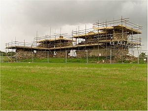
In 2009, a team of stonemasons worked to make King John's Palace safe and stable. This work was part of a project funded by English Heritage and Nottinghamshire County Council. Today, archaeologists are still studying the site to learn more about its past.
Contents
The Royal Hunting Lodge
Building the Palace and Deer Park
The King's Houses were built in Clipstone because it was right in the middle of Sherwood Forest. In the Middle Ages, a "forest" wasn't just a place with trees. It was a special area where the king's hunting laws were in force. These laws protected animals like deer, which were important for the king's hunts. They also protected the woodlands where these animals lived. The forest laws applied to the land no matter who owned it.
In the 1200s, Sherwood Forest was very large. It stretched from the River Trent in the south to the River Meden in the north. It also went from Wellow in the east to Sutton-in-Ashfield in the west. Some experts think it might have covered almost all of Nottinghamshire in the 1100s. Sherwood Forest was already well-known by 1164.
Experts believe the main building you see today was built during the time of King Henry II. This is because it has special Romanesque features. These types of designs were not used much after the late 1100s.
Royal Visits and Changes Over Time
Clipstone was a favorite place for kings and queens to visit for over 200 years. Many kings stayed there, including:
- Henry II in 1181 and 1185.
- Richard I in 1194.
- John in 1200, 1201, 1205, 1210, and 1215.
- Henry III in 1244, 1251, and 1255.
- Edward I in 1279, 1280, 1284, 1290, and 1300.
- Edward II in 1307, 1315, 1316, 1317, 1318, and 1320.
- Edward III in 1327, 1328, 1330, 1331, 1332, 1334, 1335, 1345, and 1363.
- Richard II in 1387 and 1393.
Sometimes these visits were very short, like King John's overnight stay in March 1200.
During King John's rule, a chapel dedicated to St Edwin was built in 1205. It's also said that King John held a special meeting, a "parliament," under a nearby tree called the Parliament Oak.
Later, under King Edward II and Edward III, the deer park was made even bigger. This caused problems for the local people in Clipstone, Warsop, and Mansfield Woodhouse. They complained because they lost their rights to collect wood, ferns, and use the land for their animals.
King Edward I ordered a stable to be built in 1282. It was big enough for 200 horses! This shows how many people and animals traveled with the king's Household. Edward II also built a small fort, or "peel," at the castle. This might have been because of the need for more farmland or political issues with Scotland.
Edward III visited the palace many times. He also reversed some of the changes Edward II made to the park. This helped the local communities get back some of their land rights. In the late 1340s, more building work was done. This included fixing the great hall, the king's and queen's kitchens, and several chapels. They used Mansfield slate for the roofs. Many important people stayed at the palace, including famous knights like Robert de Morley.
A map of Sherwood Forest from around 1400 shows Clipstone Park clearly. It was a fenced area with names like "ye pele" (Clipstone Peel) and "Clipston ye dam" (the dam for the Great Pond). The River Maun flowed through the park. The palace eventually passed to George, Duke of Clarence, but after he was executed in 1478, it went back to the crown.
The Palace Falls into Disrepair
During the 1400s, kings and queens became less interested in the King's Houses. This was part of a bigger trend across England. Kings started to prefer fewer, but much grander, palaces. These new palaces were often located in south-east England.
By 1525, a report on "the decays of the manor of Clipstone" said:
- The south-east end of the main room was "in great decay and ruin."
- Part of the roof and floor had fallen down.
- A stone staircase was started but never finished, which caused more damage.
- The chapel had no roof.
- The kitchen roof needed fixing.
- Two chimneys in the kitchen were started but not finished.
After the Middle Ages
Selling the Estate
The manor and park of Clipstone stopped being royal property in 1603. King James I gave it to Charles Blount. He quickly sold it to Gilbert Talbot the next year.
William Cavendish's Ownership
William Cavendish bought the estate in 1630. He immediately asked William Senior, a mapmaker, to create a map of his new land. This map still exists today. It shows that much of the area was woodland. It also shows that some of the beautiful landscapes from the medieval period were still there.
The map only shows a few buildings near the ruin. One was a house to the north-west. Another was a rectangular area to the north, which was probably a village pinfold (where stray animals were kept). There was also a property further east. This last building might have been the ruined gatehouse of the palace. Today, modern houses like Brammer Farm House and Maun Cottage stand in the same spot. These houses have very thick stone walls, similar to the palace ruin. Fancy stonework was found in their gardens in 2007.
Clipstone Park was almost completely destroyed during the English Civil War. William Cavendish supported the king, so he went into exile in 1644. While he was away, the park's fences and trees were used to help the Parliament's war efforts. The deer also disappeared. When Cavendish's wife, Margaret, returned in 1665, she said the losses were huge. She described how the fences were torn down and the great oak trees were gone. This left the deer and other animals with no food or shade, causing them to die.
Early Historians and the Ruins
In 1677, a historian named Robert Thoroton described a similar sad scene. He said there was "scarcely any ruins left at all of the king's old house, except a piece of thick Stone Wall." He also noted that the park had lost its "Gallant Oaks." Thoroton's description suggests that only one building was left by the 1600s. Many stones from the palace were probably taken and used to build other things in the village, like Clipstone Hall.
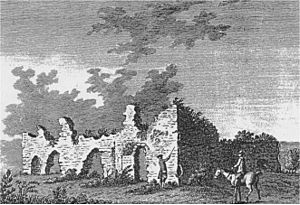
Clipstone later became owned by William Bentinck, 2nd Duke of Portland in 1734. Four old pictures of the ruins from the late 1700s still exist. They were drawn by artists like Francis Grose (1772) and Samuel Hieronymus Grimm (1773).
The Duke of Portland's Flood Meadows
William Bentinck, 4th Duke of Portland started a big project to create flood meadows along the River Maun. These meadows were meant to grow more hay to feed sheep in winter. The project cost a lot of money, almost £40,000. The Duke paid good wages to the workers, which was helpful during a time when many people were unemployed. The flood meadows went right through Clipstone Park. It seems this construction work damaged the King's Houses. After the project finished in 1844, a local directory said that much of the palace's foundations were dug up in 1816 to help with draining the land. Even though the Duke had given strict orders not to damage the old walls, a lot of harm was done.
Recent Discoveries and Conservation
20th and 21st Centuries
The site continued to be used as a farm field in the 1900s. It was known as Castle Field. It stayed owned by the Welbeck Estate until 1945. Then, local farmers Fred and Molly Bradley bought it. The land has been in the Bradley family ever since.
Conservation work was done on the ruin in 1991 and 2009. In 1991, part of the structure was about to fall down. It was supported with new stone blocks. This work was overseen by Nottinghamshire County Council. In 2009, more extensive work was done to make the ruin stable. This included fixing the stone, filling cracks, and protecting the top of the walls. This project was paid for by English Heritage and Nottinghamshire County Council.
Archaeological Investigations
Many archaeological studies have happened at the site. These include:
- Digs: Philip Rahtz (1956), Trent & Peak Archaeology (1991), and the TV show Time Team (2011) have all dug trenches to explore the site.
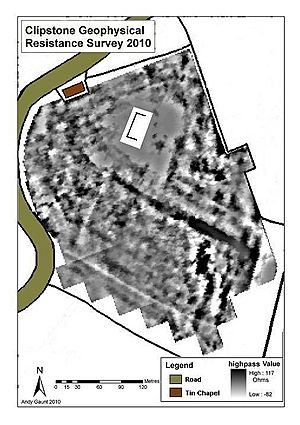
- Surveys: Special equipment was used to find hidden walls and features underground. This was done by Masters (2004) and Gaunt (2010).
- Building Analysis: Experts like James Wright (2004, 2005, 2007) studied the standing ruins and old stonework in nearby buildings.
Philip Rahtz's dig in 1956 uncovered a large medieval complex. It spread over about two acres. However, not many small items from daily life were found during this work. The 2004 survey found hidden foundations of walls and ditches. It also found places where old walls had been dug up for their stone.
Andy Gaunt's 2010 survey covered the entire Castlefield. It confirmed many earlier findings and added new discoveries. His work suggested:
- A large rectangular area around the monument was likely a courtyard. It had buildings around its edges and a wall or fence.
- A long, strong line underground was probably a ditch filled with rubble or the remains of a wall. This likely marked the edge of the palace area.
- A large rectangular area probably showed where a big building had collapsed.
- Evidence of an old road with drainage ditches. This suggests there might have been a gateway to the palace from the north.
- Possible defensive walls or boundaries to the north-east.
In 2004-2005, a survey recorded the condition of the main walls. These walls seem to have been part of a building that was at least two stories high. James Wright also looked at stone fragments in local properties in 2007. He found medieval and post-medieval stone, including carved pieces. These might have come from the palace gateway. Many local houses have stone foundations and walls that could have been built using stones taken from the palace.
In April 2011, the TV show Time Team filmed an episode at King John's Palace. They dug trenches to check the findings from the 2010 survey. Many experts were involved, including historians and archaeologists.
In July 2012, archaeologists dug two more trenches. They wanted to see if a long underground line found in 2011 was the palace boundary ditch. They found a ditch about 5.5 meters (18 feet) wide. They also found pottery from the 1200s and 1300s. This suggests it was indeed the palace boundary. The total area enclosed by the palace would have been about 7.5 acres. This makes King John's Palace one of the largest royal palace sites in England!
In February 2013, volunteers and staff from Mercian Archaeological Services dug 15 test pits in King's Clipstone. James Wright also studied Brammer Farm House and Arundel Cottage. He found that the boundary wall of the King's Houses still exists as a main wall within both properties. It goes up to the first floor. There's also evidence of other walls and a special window.
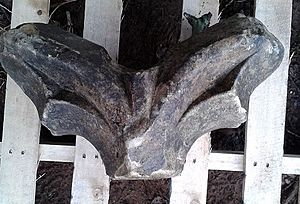
In November 2014, Keith and Andrea Laver, who own land near the palace, found a piece of fancy window tracery. This was found in a hedgerow about 100 meters (328 feet) south-east of the palace. An archaeologist said it was a high-quality piece of window design made from Mansfield White stone. It had clear channels for glass and decorative carvings.
Visiting the Palace
King John's Palace is a Grade II listed building and a Scheduled Ancient Monument. This means it's a very important historical site. It stands on private land. However, you can visit the site if you ask the Bradley family (the landowners) of Waterfield Farm in King's Clipstone in advance.
In the summer of 2009, a special information panel was put up at the palace. It has a drawing by local artist Ray Straw showing what the palace might have looked like in the mid-1300s. The panel is attached to the wall that was repaired in 1991.
There is also an annual open day in July called the "Picnic at the Palace." You can usually find details about this event on the Council For British Archaeology's Festival of British Archaeology webpage.
 | Kyle Baker |
 | Joseph Yoakum |
 | Laura Wheeler Waring |
 | Henry Ossawa Tanner |


