
Kings Meadows, Tasmania facts for kids
Quick facts for kids Kings MeadowsLaunceston, Tasmania |
|||||||||||||||
|---|---|---|---|---|---|---|---|---|---|---|---|---|---|---|---|

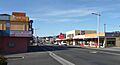
View south down Hobart Road through Kings Meadows
|
|||||||||||||||

Kings Meadows
Location in Tasmania
|
|||||||||||||||
| Population | 3,670 (2016 census) | ||||||||||||||
| Postcode(s) | 7249 | ||||||||||||||
| Location | 4 km (2 mi) S of Launceston, Tasmania | ||||||||||||||
| LGA(s) | Launceston | ||||||||||||||
| Region | Launceston | ||||||||||||||
| State electorate(s) | Bass | ||||||||||||||
| Federal Division(s) | Bass | ||||||||||||||
|
|||||||||||||||
Kings Meadows is a friendly suburb located in the southern part of Launceston, a city in Tasmania, Australia. It's a great place to live, with a population of 3670 people recorded in the 2016 census. This suburb is about 5 kilometers (3 miles) south of Launceston's main city area.
Kings Meadows sits in a shallow valley, about 70 meters (230 feet) above sea level. This valley gently slopes northeast towards the small suburb of Punchbowl. You can easily reach Kings Meadows from the city center by taking Hobart Road, passing through South Launceston. A well-known school, Kings Meadows High School, is also located right here in the suburb.
Contents
Exploring Kings Meadows: A Quick Guide
Kings Meadows is a residential area, meaning it's mostly made up of homes where people live. It's part of the Launceston local government area.
A Glimpse into the Past: How Kings Meadows Began
Kings Meadows was officially recognized as a specific area in 1963. Before that, it was just part of the larger Launceston region. The suburb even had its own Post Office for a short time, opening in 1915 and closing in 1926.
Getting Around: Roads and Transport
Kings Meadows has good road connections that help people travel easily.
Major Roads Connecting Kings Meadows
The Midland Highway, which is a major road in Tasmania, runs along most of the western edge of Kings Meadows. This highway is like a main artery, connecting different towns. Another important road is Kings Meadows Link (Route C403). This road goes through the southeastern part of the suburb, making it easy to get from one side to the other.
Images for kids
-
View south down Hobart Road through Kings Meadows
