Kirkwood, Pennsylvania facts for kids
Quick facts for kids
Kirkwood, Pennsylvania
|
|
|---|---|

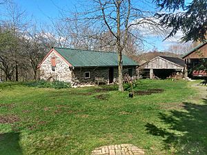
Farm in Kirkwood
|
|
| Country | United States |
| State | Pennsylvania |
| County | Lancaster |
| Township | Colerain |
| Area | |
| • Total | 2.23 sq mi (5.76 km2) |
| • Land | 2.22 sq mi (5.75 km2) |
| • Water | 0.00 sq mi (0.01 km2) |
| Elevation | 518 ft (158 m) |
| Population
(2020)
|
|
| • Total | 388 |
| • Density | 174.62/sq mi (67.43/km2) |
| Time zone | UTC-5 (Eastern (EST)) |
| • Summer (DST) | UTC-4 (EDT) |
| ZIP code |
17536
|
| FIPS code | 42-39944 |
| GNIS feature ID | 1203948 |
Kirkwood is a small farming community in Lancaster County, Pennsylvania, United States. It's a special kind of town called a census-designated place (CDP). This means the government counts its population, but it doesn't have its own city government. Kirkwood is part of the beautiful Pennsylvania Dutch Country, known for its farms and unique culture. In 2020, about 388 people lived here. Its ZIP code is 17536.
Contents
History of Kirkwood
Kirkwood has a simple but interesting history.
Early Beginnings and Growth
The town's post office was opened in 1856. This helped people send and receive mail more easily. Later, in 1899, a school was built in Kirkwood. This was an important step for the community, as it meant local children could get an education close to home.
Amish Settlers Arrive
A big change happened in Kirkwood in 1935. That's when Amish families started to move to the area. Isaac and Mary Zook, along with their nine children, were among the first Amish settlers. The Amish are known for their simple lifestyle and farming traditions. Their arrival added to the unique culture of Kirkwood and the surrounding Pennsylvania Dutch Country.
Geography of Kirkwood
Kirkwood is located in a lovely part of southeastern Lancaster County.
Location and Roads
You can find Kirkwood at these coordinates: 39° 50' 50" North and 76° 5' 0" West. It's right in the middle of Colerain Township. A main road, Pennsylvania Route 472, runs through the center of town. If you travel northwest on this road, you'll reach Quarryville in about 6 miles (10 kilometers). If you go southeast, you'll get to Oxford in Chester County, which is about 7 miles (11 kilometers) away.
Land and Water Features
The Kirkwood area covers about 2.23 square miles (5.76 square kilometers) of land. Only a tiny part, about 0.004 square miles (0.01 square kilometers), is water. The community's water flows into two branches of the Octoraro Creek. These are the West Branch and the East Branch. Eventually, the water from Octoraro Creek joins the larger Susquehanna River. The center of Kirkwood sits at an elevation of about 522 feet (159 meters) above sea level.
People of Kirkwood
Understanding the people who live in a place is called demographics.
| Historical population | |||
|---|---|---|---|
| Census | Pop. | %± | |
| 2020 | 388 | — | |
| U.S. Decennial Census | |||
Population Numbers
According to the 2020 census, 388 people lived in Kirkwood. This means there were about 67 people for every square kilometer of land. In the 2010 census, the population was 396 people.
Community Makeup
In 2010, most of the people living in Kirkwood (about 98%) were white. A small number of residents were from other backgrounds. This mix of people helps make Kirkwood a unique place.
See also
 In Spanish: Kirkwood (Pensilvania) para niños
 | Percy Lavon Julian |
 | Katherine Johnson |
 | George Washington Carver |
 | Annie Easley |


