
Kitchenuhmaykoosib Inninuwug First Nation facts for kids
Quick facts for kids
Kitchenuhmaykoosib Aaki 84
ᑭᐦᒋᓇᒣᑯᐦᓯᑊ ᐃᓂᓂᐧᐊᐠ
|
||
|---|---|---|
| Kitchenuhmaykoosib Aaki (Big Trout Lake) Indian Reserve No. 84 | ||
|
||

Kitchenuhmaykoosib Aaki 84
Location in Ontario
|
||
| Country | ||
| Province | ||
| District | Kenora | |
| First Nation | Kitchenuhmaykoosib Inninuwug | |
| Area | ||
| • Land | 289.96 km2 (111.95 sq mi) | |
| Population
(2016)
|
||
| • Total | 1,024 | |
| • Density | 2.8/km2 (7/sq mi) | |
| Website | www.bigtroutlake.firstnation.ca | |
Kitchenuhmaykoosib Inninuwug (pronounced Kitch-en-uh-may-koo-sib In-in-oo-wug) is a special First Nation community in Northwestern Ontario, Canada. It is also known as Big Trout Lake First Nation or KI for short. The people here speak Oji-Cree (also called Anishininiimowin) and English. This community is part of Treaty 9, an important agreement about land.
The community's land is called the Kitchenuhmaykoosib Aaki 84 Reserve. It covers a large area of almost 300 square kilometers (about 74,000 acres). This land is located on the north shore of Big Trout Lake. Big Trout Lake is a fly-in community, meaning you can usually only get there by plane. In the colder months, a winter road also connects the community to other areas.
Contents
About the Kitchenuhmaykoosib Inninuwug Community
Community Size and Leadership
In January 2007, about 1,322 people lived in Big Trout Lake. This makes it one of the largest First Nations communities in its region.
The community is led by a chief and deputy chief. The current chief is Donny Morris and the deputy chief is Darryl Sainnawap. There are also several band councillors who help make decisions for the community. These councillors include Cecelia Begg, Joseph Mckay, Enos Mckay, Randy Nanokeesic, Bonnie Sanderson, and Jack Mckay.
Local Businesses and Services
The community has three stores that are owned by local people. These stores provide groceries, clothes, fuel, and other important supplies. These businesses are very important because the community decided to keep them locally owned. This happened after a larger company, The North West Company, was asked to leave in 1996.
Big Trout Lake also has a post office and a bank agency from the Canadian Imperial Bank of Commerce. There is even a community radio station, 100.3 FM. This station broadcasts local news, health announcements, and even Sunday mass. It also shares programs from the Wawatay Native Communications Society.
Community Safety and Policing
The Big Trout Lake Police force keeps the community safe. This police force works with the Ontario Provincial Police (OPP). Only a few First Nations in Ontario have this kind of agreement. Most others are policed directly by the OPP or another service.
Water, Sewage, and Transportation
Some homes on the island part of the community have running water through underground pipes. Homes on the mainland get their water delivered by tanker trucks. There are also underground pipes for sewage on the island, leading to two special treatment areas. Other parts of the community have their sewage collected by a truck.
The community is mainly reached by air. Wasaya Airways has regular flights to the Big Trout Lake Airport. The airport has a gravel runway that is about 1,191 meters (3,907 feet) long. In the winter, a special winter road connects the community to Pickle Lake. Pickle Lake is on Ontario Highway 599, which is the northernmost highway in the province.
Healthcare Services
Healthcare in the community has changed a lot over time. Long ago, the Hudson's Bay Company post master would give out medicines. The first nursing station was built in 1938. A new one was built in 1950, and the current one was built in 1973.
Unlike most of Ontario, healthcare here is managed by the federal Health Canada. The nursing station has six nurses and a doctor who is there from Monday to Friday. Specialists like eye doctors and dentists also visit. The station even hosts medical students from the Northern Ontario School of Medicine each May.
History of Kitchenuhmaykoosib Inninuwug
Ancient Roots and Early European Contact
Scientists have found signs that people have lived in this area for at least 7,000 years. The original people of this region are called Inninuwug. Early Europeans sometimes called them Cree. This area was a traditional meeting place for centuries because it's located at the head of the Fawn River, which flows into the Severn River and then to Hudson Bay.
The first European trader recorded here was James Swain in 1807. He came to set up a trading post for the Hudson's Bay Company (HBC). He found old ruins from another trading company, the North West Company, which might have been there as early as 1793.
Fur Trade and Cultural Changes
The HBC trading post, built in 1830, was very important for trading furs. People traded furs for goods, and everything was valued based on the "Made Beaver" (MB) pelt. For example, a blanket might cost 6 MB. Local people were hired to transport furs down the Fawn River to the Severn River and then to Fort York (now Churchill, Manitoba). These trips took five days downstream and fifteen days upstream.
Christianity came to the area as early as the late 1700s through fur traders. In 1872, missionary W.W. Kirkby formally brought the Anglican faith. He was surprised to find that many community members were already Christian. They were reading biblical texts written in Canadian Aboriginal syllabics, sometimes on birch bark. These texts came from people living in Fort York. One island near Big Trout Lake is even called "Catholic's dwelling island."
Modern Communications and Development
In 1940, a weather station was built in the community. It sent hourly weather reports to the department of transport. This station was made bigger in 1952 and had six staff members. Today, this building is used as the Health Administration office.
Regular communication with the outside world began with "radio skeds." These were regular Morse Code messages between the weather station and the Winnipeg Airport. Phone service arrived in 1963 using HF radio, and it was upgraded to satellite service in 1975.
Protecting Traditional Lands

In 2008, six leaders from the Kitchenuhmaykoosib Inninuwug community faced challenges for peacefully standing up for their traditional land. A company called Platinex wanted to explore for minerals on their land, but the community leaders disagreed. The leaders, including Chief Donny Morris, Jack McKay, Sam McKay, Darryl Sainnawap, Cecilia Begg, and Bruce Sakakeep, were held for their peaceful actions.
During this time, a sacred fire was lit in front of the jail where they were held, but police put it out. Many people felt this was unfair and went against their rights. Members of KI and other First Nations walked all the way from Kenora, Ontario, to Toronto, Ontario, to protest. The leaders were later allowed to attend a protest at Queen's Park and were permanently freed a few days later.
In 2012, Chief Donny Morris and his wife were invited to New Zealand. They shared their story about protecting their land and working with the government.
Climate
| Climate data for Big Trout Lake | |||||||||||||
|---|---|---|---|---|---|---|---|---|---|---|---|---|---|
| Month | Jan | Feb | Mar | Apr | May | Jun | Jul | Aug | Sep | Oct | Nov | Dec | Year |
| Record high humidex | 2.4 | 6.9 | 10.2 | 23.2 | 32.5 | 34.0 | 44.0 | 39.9 | 34.1 | 25.4 | 11.1 | 4.5 | 44.0 |
| Record high °C (°F) | 1.9 (35.4) |
7.7 (45.9) |
12.2 (54.0) |
24.4 (75.9) |
32.4 (90.3) |
31.7 (89.1) |
35.6 (96.1) |
32.9 (91.2) |
30.6 (87.1) |
24.4 (75.9) |
12.2 (54.0) |
4.7 (40.5) |
35.6 (96.1) |
| Mean daily maximum °C (°F) | −18.5 (−1.3) |
−14.2 (6.4) |
−6.0 (21.2) |
3.2 (37.8) |
12.0 (53.6) |
17.4 (63.3) |
21.2 (70.2) |
19.5 (67.1) |
11.7 (53.1) |
4.4 (39.9) |
−5.6 (21.9) |
−15.7 (3.7) |
2.5 (36.5) |
| Daily mean °C (°F) | −23.7 (−10.7) |
−20.5 (−4.9) |
−13.4 (7.9) |
−3.1 (26.4) |
5.9 (42.6) |
12.0 (53.6) |
16.2 (61.2) |
14.8 (58.6) |
7.9 (46.2) |
1.3 (34.3) |
−9.1 (15.6) |
−20.3 (−4.5) |
−2.7 (27.1) |
| Mean daily minimum °C (°F) | −29 (−20) |
−26.7 (−16.1) |
−20.8 (−5.4) |
−9.4 (15.1) |
−0.3 (31.5) |
6.6 (43.9) |
11.2 (52.2) |
10.2 (50.4) |
4.0 (39.2) |
−1.8 (28.8) |
−12.5 (9.5) |
−24.9 (−12.8) |
−7.8 (18.0) |
| Record low °C (°F) | −47.8 (−54.0) |
−46.7 (−52.1) |
−42.2 (−44.0) |
−32.8 (−27.0) |
−20.6 (−5.1) |
−7.2 (19.0) |
−1.1 (30.0) |
−1.1 (30.0) |
−7.8 (18.0) |
−19.3 (−2.7) |
−36 (−33) |
−44.4 (−47.9) |
−47.8 (−54.0) |
| Record low wind chill | −60.3 | −59.0 | −50.5 | −38.6 | −30.4 | −11.2 | −6.0 | −5.5 | −17.7 | −25.0 | −47.0 | −55.8 | −60.3 |
| Average precipitation mm (inches) | 23.0 (0.91) |
20.6 (0.81) |
27.9 (1.10) |
32.2 (1.27) |
37.8 (1.49) |
74.3 (2.93) |
90.9 (3.58) |
87.8 (3.46) |
83.0 (3.27) |
52.7 (2.07) |
50.1 (1.97) |
28.8 (1.13) |
609.1 (23.98) |
| Average rainfall mm (inches) | 0 (0) |
0 (0) |
2.2 (0.09) |
12.0 (0.47) |
27.8 (1.09) |
70.8 (2.79) |
90.9 (3.58) |
87.8 (3.46) |
73.8 (2.91) |
27.6 (1.09) |
4.6 (0.18) |
1.0 (0.04) |
398.5 (15.69) |
| Average snowfall cm (inches) | 26.0 (10.2) |
22.6 (8.9) |
28.2 (11.1) |
21.3 (8.4) |
10.4 (4.1) |
3.4 (1.3) |
0 (0) |
0 (0) |
9.3 (3.7) |
25.9 (10.2) |
48.4 (19.1) |
31.7 (12.5) |
227.2 (89.4) |
| Average precipitation days (≥ 0.2 mm) | 13.8 | 12.1 | 11.2 | 9.1 | 10.4 | 14.1 | 15.2 | 14.6 | 16.1 | 14.9 | 17.4 | 16.4 | 165.3 |
| Average rainy days (≥ 0.2 mm) | 0.10 | 0.14 | 0.73 | 3.3 | 8.3 | 13.7 | 15.1 | 14.6 | 15.1 | 8.4 | 2.1 | 0.48 | 82.0 |
| Average snowy days (≥ 0.2 cm) | 14.0 | 12.1 | 10.9 | 6.9 | 4.0 | 1.2 | 0.05 | 0 | 2.7 | 9.3 | 17.0 | 16.4 | 94.4 |
| Average relative humidity (%) | 77.0 | 74.2 | 68.6 | 60.4 | 53.8 | 56.5 | 57.4 | 61.0 | 66.2 | 74.2 | 80.2 | 79.8 | 67.4 |
| Source: Environment Canada | |||||||||||||
Images for kids
-
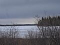
Looking North from 'KI' island to mainland in April 2012
-
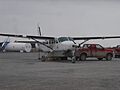
A Wasaya Airways Plane at KI airport
-
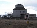
The KI Health Office, which used to be an old Weather Station

.jpg)

