
Klamath, California facts for kids
Quick facts for kids
Klamath, California
|
|
|---|---|

Location in Del Norte County and the state of California
|
|

Klamath, California
Location in the United States
|
|
| Country | United States |
| State | California |
| County | Del Norte |
| Area | |
| • Total | 12.541 sq mi (32.480 km2) |
| • Land | 12.541 sq mi (32.480 km2) |
| • Water | 0 sq mi (0 km2) 0% |
| Elevation | 30 ft (9 m) |
| Population
(2020)
|
|
| • Total | 1,088 |
| • Density | 86.76/sq mi (33.498/km2) |
| Time zone | UTC-8 (Pacific (PST)) |
| • Summer (DST) | UTC-7 (PDT) |
| ZIP code |
95548
|
| Area code(s) | 707 |
| FIPS code | 06-38702 |
| GNIS feature ID | 0277534 |
Klamath is a small community in Del Norte County, California. Its name in the Tolowa language is Taa-chit. It is located along US Route 101, close to where the Klamath River meets the ocean.
Klamath is considered an unincorporated community. This means it is not officially a city with its own local government. It is also a census-designated place (CDP). This is a special area defined by the government for counting people.
The community is about 30 feet (9 meters) above sea level. It is also part of the Yurok Indian Reservation. In 2020, about 1,088 people lived in Klamath.
A big flood in 1964 destroyed the original town center. You can still see old streets and sidewalks from that time. They are located west of the current main part of town.
Contents
Geography and Climate
Klamath covers an area of about 12.5 square miles (32.5 square kilometers). All of this area is land.
Klamath's Weather
Klamath has a type of weather called a Mediterranean climate. This means it has warm, dry summers. The summers are not usually very hot. Average monthly temperatures do not go above 71.6°F (22°C).
Winters are mild and wet. The area gets a lot of rain, especially from November to March. Snowfall is very rare in Klamath.
| Climate data for Klamath | |||||||||||||
|---|---|---|---|---|---|---|---|---|---|---|---|---|---|
| Month | Jan | Feb | Mar | Apr | May | Jun | Jul | Aug | Sep | Oct | Nov | Dec | Year |
| Record high °F (°C) | 75 (24) |
80 (27) |
81 (27) |
86 (30) |
91 (33) |
98 (37) |
89 (32) |
93 (34) |
95 (35) |
90 (32) |
78 (26) |
72 (22) |
98 (37) |
| Mean daily maximum °F (°C) | 54.4 (12.4) |
56.3 (13.5) |
56.7 (13.7) |
58.5 (14.7) |
61.8 (16.6) |
64.8 (18.2) |
66.3 (19.1) |
66.7 (19.3) |
67.2 (19.6) |
64.2 (17.9) |
58.6 (14.8) |
54.6 (12.6) |
60.8 (16.0) |
| Daily mean °F (°C) | 46.4 (8.0) |
47.9 (8.8) |
48.4 (9.1) |
50.2 (10.1) |
53.6 (12.0) |
57.7 (14.3) |
58.9 (14.9) |
59.4 (15.2) |
58.5 (14.7) |
55.1 (12.8) |
50.3 (10.2) |
46.6 (8.1) |
52.7 (11.5) |
| Mean daily minimum °F (°C) | 38.4 (3.6) |
39.6 (4.2) |
40.1 (4.5) |
42 (6) |
45.4 (7.4) |
49.1 (9.5) |
51.6 (10.9) |
52.2 (11.2) |
49.8 (9.9) |
46 (8) |
42.1 (5.6) |
38.7 (3.7) |
44.6 (7.0) |
| Record low °F (°C) | 18 (−8) |
19 (−7) |
24 (−4) |
27 (−3) |
24 (−4) |
33 (1) |
34 (1) |
36 (2) |
24 (−4) |
28 (−2) |
22 (−6) |
16 (−9) |
16 (−9) |
| Average precipitation inches (mm) | 13.86 (352) |
10.79 (274) |
10.51 (267) |
5.72 (145) |
3.63 (92) |
1.42 (36) |
0.32 (8.1) |
0.73 (19) |
1.71 (43) |
5.66 (144) |
11.68 (297) |
14.05 (357) |
80.09 (2,034) |
| Average snowfall inches (cm) | 0.4 (1.0) |
0.4 (1.0) |
0.1 (0.25) |
0 (0) |
0 (0) |
0 (0) |
0 (0) |
0 (0) |
0 (0) |
0 (0) |
0 (0) |
0.1 (0.25) |
1.1 (2.8) |
| Average precipitation days | 17 | 15 | 16 | 12 | 8 | 5 | 2 | 2 | 4 | 8 | 15 | 17 | 121 |
People in Klamath
Klamath is home to a diverse group of people. In 2010, the population was 779. Many residents are from different backgrounds.
Population Details
In 2010, almost half of the people in Klamath were White. A large number, about 41.7%, were Native American. A smaller percentage were Asian or from other races. About 11.6% of the population was Hispanic or Latino.
Most people in Klamath live in family homes. Only a very small number live in group housing. The average household had about 2.5 people. Families were a bit larger, with about 3.2 people on average.
The community has people of all ages. About 23.5% were under 18 years old. About 18.5% were 65 years or older. The average age was around 43 years old.
Economy
Historically, salmon fishing was a very important part of Klamath's economy. However, in recent years, the number of fish has gone down a lot. This is due to disagreements over water use upstream.
Fun Facts and Culture
Klamath has some unique attractions that draw visitors.
Trees of Mystery
At a place called Trees of Mystery, you can see a huge statue. It is a 35-foot (11-meter) tall statue of Babe the Blue Ox. Babe is the famous sidekick of Paul Bunyan, a legendary lumberjack.
Drive-Through Tree
Klamath is also home to one of only three California redwood trees that you can actually drive a car through! It's a very cool experience to see these giant trees up close.
Notable People
- Tom Darby – He is an American journalist, author, and blogger. He was also inducted into the Nevada Broadcast Hall of Fame.
Images for kids
-
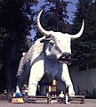
Babe the Blue Ox and Trees of Mystery in Klamath
-
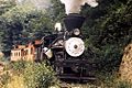
KHV No. 10, a 3-truck Heisler locomotive on the Klamath & Hoppow Valley Railroad, 1972


See also
 In Spanish: Klamath (California) para niños
