
Knocknashee facts for kids
Quick facts for kids Knocknashee |
|
|---|---|
| Cnoc na Sí | |

|
|
| Highest point | |
| Elevation | 276 m (906 ft) |
| Prominence | 171 m (561 ft) |
| Listing | Marilyn |
| Naming | |
| English translation | Hill of fairies |
| Language of name | Irish |
| Geography | |

Knocknashee
Location in Ireland
|
|
| Parent range | Ox Mountains |
| OSI/OSNI grid | G556192 |
Knocknashee, known as Cnoc na Sí in Irish, is a special hill in County Sligo, Ireland. It stands about 276 meters (906 feet) tall and is part of the Ox Mountains. This hill is famous for its ancient history and the interesting stories behind its name.
Contents
What is Knocknashee?
Knocknashee is a type of hill called a Marilyn. This means it is a mountain or hill in the British Isles that is at least 150 meters (492 feet) high. It is a significant landmark in the Irish countryside.
Where is Knocknashee Located?
This interesting hill is found in County Sligo, in the western part of Ireland. A well-known river, the River Moy, actually starts flowing from the very bottom of Knocknashee.
What is Knocknashee Made Of?
The top part of Knocknashee hill is made of a type of rock called limestone. Below this limestone, on the lower parts of the hill, you would find softer rocks known as shales.
Ancient Secrets of Knocknashee
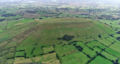
Knocknashee is not just a hill; it's also an ancient hillfort. This means it was once a protected settlement on top of a hill. It was discovered in 1988 during a special aerial survey of County Sligo.
The fort on Knocknashee is quite large. It stretches about 700 meters (2,300 feet) long and 320 meters (1,050 feet) wide. It covers a huge area of 53 acres, which is like having 40 football fields!
This ancient fort was protected by two large walls made of earth and stone, called ramparts. Inside these walls, archaeologists found many interesting things. These include stone piles called cairns, which were often used as burial places. They also found old burial chambers and places where huts once stood.
The Meaning of the Name
The name "Knocknashee" comes from the Irish words. "Knock" (cnoc) means 'hill'. "Shee" (sí) can mean 'burial mound' or 'of the fairies'. So, Knocknashee can be understood as the 'Hill of fairies' or the 'Hill of the burial mound'. In older times, Knocknashee was also known by another name, Mullinabreena.
Images for kids
-
Knocknashee hill from a distance.

