Koshkonong, Wisconsin facts for kids
Quick facts for kids
Town of Koshkonong, Wisconsin
|
|
|---|---|

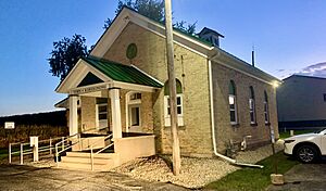
Town hall
|
|

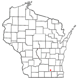
Location of the Town of Koshkonong, Wisconsin
|
|
| Country | |
| State | |
| County | Jefferson |
| Area | |
| • Total | 42.6 sq mi (110.3 km2) |
| • Land | 41.4 sq mi (107.3 km2) |
| • Water | 1.2 sq mi (3.0 km2) |
| Elevation | 810 ft (250 m) |
| Population
(2020)
|
|
| • Total | 3,763 |
| • Density | 88.36/sq mi (34.116/km2) |
| Time zone | UTC-6 (Central (CST)) |
| • Summer (DST) | UTC-5 (CDT) |
| FIPS code | 55-40375 |
| GNIS feature ID | 1583494 |
Koshkonong is a town in Jefferson County, Wisconsin, United States. In 2020, about 3,763 people lived here. The town completely surrounds the city of Fort Atkinson. Some smaller communities like Koshkonong Mounds and Vinnie Ha Ha are also part of the town. Other areas like Blackhawk Island and Lake Koshkonong are partly in Koshkonong.
Contents
History of Koshkonong
Long ago, Native American peoples like the Sauk, Meskwaki, Potawatomi, and Ho-Chunk lived in this area. Later, French traders from Canada were some of the first Europeans to arrive.
The Potawatomi people called the area around the Yahara River Gishkzhegonang, which meant "Catfish Place." This name was later changed to "Koshkonong" in English. They called Lake Koshkonong Éndayang-zagegen, meaning "Lake Where-we-live-on."
The first farmers settled here around 1836. In 1839, when Wisconsin was a territory, the town was first called Finch. But in 1842, its name was changed to Koshkonong.
In the 1840s, many families from Norway came to live in the United States. A large group of Norwegian-Americans settled in Koshkonong. By 1850, more than half of all Norwegian immigrants in Wisconsin lived in the Koshkonong Settlement. They called it Kaskeland in their language.
Geography of Koshkonong
Koshkonong covers about 110.3 square kilometers (42.6 square miles). Most of this area, about 107.3 square kilometers (41.4 square miles), is land. The rest, about 3.0 square kilometers (1.2 square miles), is water.
Part of the western edge of the town is along the southeast shore of Lake Koshkonong. A major road, U.S. Route 12, goes through the town from the southeast to the northwest. It also passes through the city of Fort Atkinson.
Population and People
| Historical population | |||
|---|---|---|---|
| Census | Pop. | %± | |
| 2000 | 3,395 | — | |
| 2010 | 3,692 | 8.7% | |
| 2020 | 3,763 | 1.9% | |
| U.S. Decennial Census | |||
In 2020, Koshkonong had a population of 3,763 people. This means there were about 35 people per square kilometer (91 people per square mile).
In 2000, there were 1,249 households in the town. Many families lived here, with 67.6% being married couples. About 33.2% of households had children under 18 living with them. The average household had about 2.69 people.
The people in Koshkonong come from different backgrounds. Most residents are White. A small number of people are Hispanic or Latino.
Notable People from Koshkonong
Many interesting people were born or lived in Koshkonong. Here are a few:
- Rasmus B. Anderson (1846–1936), a well-known scholar.
- Charles N. Herreid (1857–1928), who became a governor of South Dakota.
- Victor Lawson (1850–1925), a famous newspaper publisher.
- Andrew E. Lee (1847–1934), another person who became a governor of South Dakota.
- Knute Nelson (1843–1923), an important politician.
- Sterling North (1906–1974), a popular author.
- Knute Rockne (1888–1931), a legendary football player.
See also
 In Spanish: Koshkonong (Wisconsin) para niños
 | Delilah Pierce |
 | Gordon Parks |
 | Augusta Savage |
 | Charles Ethan Porter |


