Koumala, Queensland facts for kids
Quick facts for kids KoumalaQueensland |
|||||||||||||||
|---|---|---|---|---|---|---|---|---|---|---|---|---|---|---|---|

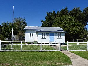
Koumala State School, 2022
|
|||||||||||||||
| Population | 772 (2021 census) | ||||||||||||||
| • Density | 0.9277/km2 (2.403/sq mi) | ||||||||||||||
| Postcode(s) | 4738 | ||||||||||||||
| Area | 832.2 km2 (321.3 sq mi) | ||||||||||||||
| Time zone | AEST (UTC+10:00) | ||||||||||||||
| Location | |||||||||||||||
| LGA(s) | Mackay Region | ||||||||||||||
| State electorate(s) | Mirani | ||||||||||||||
| Federal Division(s) | Capricornia | ||||||||||||||
|
|||||||||||||||
Koumala is a small country town in the Mackay Region of Queensland, Australia. It is also a coastal area. In 2021, about 772 people lived in Koumala.
Contents
Exploring Koumala's Landscape
Koumala is a place with interesting natural features. To the east, you'll find Cape Palmerston National Park. This park protects the land around Mount Funnel and Cape Palmerston. It's a great spot for nature lovers.
The Hatfield Range and Railway
To the west of Koumala is the Hatfield Range. Locals often call it the Koumala Range. A gravel road goes over this range. It offers another way to get to the Sarina area. This road was very important after Cyclone Debbie caused landslides. For several years, it was the only route available.
The main railway line also crosses this range. This line carries coal from the Bowen Basin mines to the port at Hay Point. Trains have to slow down to 60 kilometers per hour (about 37 miles per hour) on the downhill part. This is because some trains have derailed there before.
Koumala's Neighbourhoods
Koumala includes several smaller areas, or neighbourhoods. These include:
- Inneston
- Karremal
- Kelvin
- Koumala South
- Loloma
You can also find Yukan railway station in the area.
What's in a Name? The Meaning of Koumala
The name Koumala comes from its railway station, which was named in 1914. It was named after a sugar farm owned by Alfred H. Burbank. He used a Fijian word that means sweet potato.
Names of Neighbourhoods
- The name Inneston comes from the Inneston railway station. It was named in 1911 after Alexander Innes. He was an important person in the sugar industry and local government.
- Karremal is another neighbourhood name from its railway station. It was named in 1920. This name is an Aboriginal word meaning heat.
- The Loloma neighbourhood also gets its name from its railway station, named in 1914.
- The name Yukan is an Aboriginal word that means rain.
A Look Back: Koumala's History
British people started settling in Koumala in the early 1860s. Mark Millet Christian set up a large farm called Kelvin Grove.
The Koumala Post Office first opened its doors on February 28, 1884. The town was once part of the Shire of Sarina.
Schools and Churches
Koumala State School welcomed its first students in August 1922. At first, the railway goods shed and some huts were used as classrooms. They were also used for community events until a proper hall was built.
Another school, Yukan State School, opened in 1929 but closed around 1942.
On May 30, 1954, the Catholic Church of the Holy Family was officially opened. It is no longer used as a church, but the building is still there.
Who Lives in Koumala?
The number of people living in Koumala has changed over the years.
- In 2011, about 789 people lived here.
- By 2016, the population grew to 831 people.
- In 2021, the population was 772 people.
Places of Interest: Heritage Sites
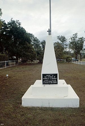
Koumala has some special places that are listed for their historical importance. One of these is the Koumala War Memorial on Mumby Street. War memorials are places that remember soldiers who served in wars.
Learning in Koumala: Education
Koumala State School is a government primary school. It teaches students from Prep (the first year of school) to Year 6. It is located on Bull Street. In 2018, the school had 114 students and 8 teachers.
There isn't a high school in Koumala. Older students usually go to Sarina State High School in the nearby town of Sarina.
Community Life: Amenities
The Mackay Regional Council provides a mobile library service in Koumala. This library on wheels visits Bull Street near the school every two weeks. It's a great way for everyone to borrow books and other materials.
The Koumala branch of the Queensland Country Women's Association (CWA) meets at the CWA Hall on Brown Street. The CWA is a group that supports women and communities, especially in rural areas.
 | Delilah Pierce |
 | Gordon Parks |
 | Augusta Savage |
 | Charles Ethan Porter |


