
Koyra Upazila facts for kids
Quick facts for kids
Koyra
কয়রা
|
|
|---|---|

Koyra Upazila
Location in Bangladesh
|
|
| Country | |
| Division | Khulna Division |
| District | Khulna District |
| Area | |
| • Total | 1,775.41 km2 (685.49 sq mi) |
| Population
(1991)
|
|
| • Total | 165,473 |
| • Density | 93.2027/km2 (241.3939/sq mi) |
| Time zone | UTC+6 (BST) |
| Postal code |
9290
|
Koyra (pronounced Coy-ra, and written as Bengali: কয়রা in Bengali) is a special kind of area in Bangladesh called an Upazila. Think of an Upazila like a county or a large sub-district. It's part of the Khulna District and is located in the Khulna Division. What's really cool about Koyra is that it's the second largest Upazila in all of Bangladesh!
Where is Koyra Located?
Koyra is found in the southwestern part of Bangladesh. Its exact location is at 22.3417 degrees North and 89.3000 degrees East. This helps people find it on a map!
Size and Population
Koyra is quite a large area, covering about 1775.41 square kilometers. That's a lot of land! Back in 1991, there were 28,061 households, which means about 28,061 families lived there. The total number of people living in Koyra at that time was 165,473.
Images for kids
-
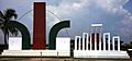
Monument and shahid minar, Koyra
-
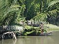
A person collecting mangrove palm leaves in the Sundarbans in Koyra.
-
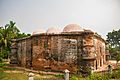
A back view of Masjidkur, an ancient mosque in Koyra discovered in the 20th century.

_-_panoramio.jpg)

