
Kungsbacka Municipality facts for kids
Quick facts for kids
Kungsbacka Municipality
Kungsbacka kommun
|
||
|---|---|---|
 |
||
|
||
 |
||
| Country | Sweden | |
| County | Halland County | |
| Seat | Kungsbacka | |
| Area | ||
| • Total | 1,482.75 km2 (572.49 sq mi) | |
| • Land | 611.42 km2 (236.07 sq mi) | |
| • Water | 871.33 km2 (336.42 sq mi) | |
| Area as of January 1, 2010. | ||
| Population
(June 30, 2012)
|
||
| • Total | 74,448 | |
| • Density | 50.2094/km2 (130.0418/sq mi) | |
| Time zone | UTC+1 (CET) | |
| • Summer (DST) | UTC+2 (CEST) | |
| ISO 3166 code | SE | |
| Province | Halland | |
| Municipal code | 1384 | |
| Website | www.kungsbacka.se | |
| Density is calculated using land area only. | ||

Kungsbacka Municipality (Kungsbacka kommun) is a local area, or municipality, in Sweden. It is located on the country's west coast in Halland County. The municipality is about 30 kilometers (18 miles) south of the big city of Gothenburg. The main town and administrative center of the municipality is also called Kungsbacka.
The municipality was formed over several years. In 1969, the area of Tölö joined the City of Kungsbacka. Then, in 1971, the municipality was officially created when the city combined with Särö. The final step happened in 1974 when three more areas joined, creating the Kungsbacka Municipality we know today.
Even though Kungsbacka Municipality is very close to Metropolitan Gothenburg and works closely with it, it is not part of Västra Götaland County. Instead, it remains part of Halland County.
A special natural place in the municipality is the glacial ridge called Fjärås bräcka. It is south of Kungsbacka. However, the most important natural feature is the beautiful coast. The municipality gets its drinking water from the nearby lake Lygnern. The water naturally filters through the Fjärås bräcka ridge, which helps make it very clean and good quality.
Towns and Villages in Kungsbacka
Kungsbacka Municipality has 22 main urban areas, which are also called tätorter or localities. These are places where many people live close together.
The table below lists these localities based on how many people lived there on December 31, 2005. The main town, which is the municipal seat, is shown in bold.
| # | Locality | Population |
|---|---|---|
| 1 | Kungsbacka | 17,784 |
| 2 | Onsala | 11,375 |
| 3 | Billdal 1) | 9,609 |
| 4 | Åsa | 3,218 |
| 5 | Särö | 2,982 |
| 6 | Fjärås kyrkby | 2,213 |
| 7 | Frillesås 2) | 1,924 |
| 8 | Backa | 1,516 |
| 9 | Vallda | 1,439 |
| 10 | Anneberg | 1,398 |
| 11 | Västra Hagen | 810 |
| 12 | Ölmanäs | 787 |
| 13 | Buerås | 556 |
| 14 | Halla Heberg | 509 |
| 15 | Lerkil | 411 |
| 16 | Gundal och Högås | 363 |
| 17 | Hagryd-Dala | 355 |
| 18 | Hjälmared | 341 |
| 19 | Brattås | 339 |
| 20 | Kläppa | 298 |
| 21 | Hjälm | 251 |
| 22 | Röda Holme | 201 |
1) Billdal is a special locality that is part of two municipalities. About 3,000 of its residents live in Gothenburg Municipality.
2) A small part of Frillesås is located in Varberg Municipality.
Images for kids
-
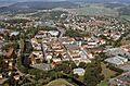
A view of Kungsbacka, the main town in the municipality.
-
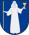
The coat of arms for Kungsbacka Municipality.
-
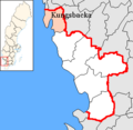
A map showing Kungsbacka Municipality within Halland County.
See also
 In Spanish: Municipio de Kungsbacka para niños
