Kyōtanabe, Kyoto facts for kids
Quick facts for kids
Kyōtanabe
京田辺市
|
|||||||||||
|---|---|---|---|---|---|---|---|---|---|---|---|

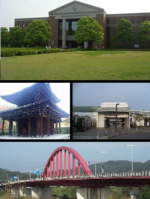
Top:A campus of Doshisha University, Middle left:Shuonan Temple, Middle right:Matsui Yamate Station, Bottom:Yamashiro Bridge
|
|||||||||||
|
|||||||||||
 |
|||||||||||
| Country | Japan | ||||||||||
| Region | Kansai | ||||||||||
| Prefecture | Kyoto | ||||||||||
| Area | |||||||||||
| • Total | 42.92 km2 (16.57 sq mi) | ||||||||||
| Population
(September 1, 2023)
|
|||||||||||
| • Total | 71,757 | ||||||||||
| • Density | 1,671.88/km2 (4,330.1/sq mi) | ||||||||||
| Time zone | UTC+09:00 (JST) | ||||||||||
| City hall address | Tanabe 80, Kyōtanabe-shi, Kyoto-fu 610-0393 | ||||||||||
| Climate | Cfa | ||||||||||
|
|||||||||||
Kyōtanabe (京田辺市, Kyōtanabe-shi) is a city in the southern part of Kyoto Prefecture, Japan. As of September 1, 2023, about 71,757 people live there. The city covers an area of about 42.92 square kilometers (16.57 sq mi).
Contents
Geography: Where is Kyōtanabe?
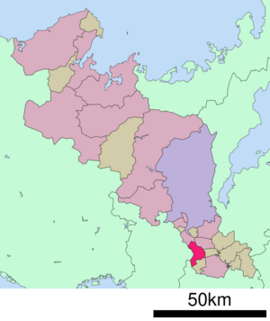
Kyōtanabe is located in southern Kyoto Prefecture. It shares borders with Osaka Prefecture and Nara Prefecture. The city is part of the "Kansai Cultural and Academic Research City" area. This means it's a special zone for learning and new ideas.
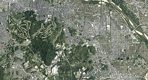
The Kizugawa River flows along the east side of the city. The Ikoma Mountains are on the west.
Cities and Towns Nearby
Kyōtanabe is surrounded by several other cities and towns.
- Jōyō
- Kizugawa
- Seika (in Sōraku District)
- Ide (in Tsuzuki District)
- Yawata
- Ikoma
Climate: What's the Weather Like?
Kyōtanabe has a humid subtropical climate. This means it has hot, humid summers and fairly cold winters. Sometimes it snows in winter.
The average temperature for the year is about 15.3°C (59.5°F). August is usually the hottest month, with temperatures around 27.5°C (81.5°F). January is the coldest, at about 4.1°C (39.4°F).
The city gets about 1429.8 mm (56 inches) of rain each year. June is the wettest month. The highest temperature ever recorded was 39.0°C (102.2°F) in August 2007. The lowest was -6.8°C (19.8°F) in February 1981.
Demographics: How Many People Live Here?
The population of Kyōtanabe has grown a lot over the last 100 years. In 1920, about 10,921 people lived there. By 2020, the population had reached 73,753 people. The city grew very quickly in the late 1900s.
| Historical population | ||||||||||||||||||||||||||||||||||||||||||||||||||||||||||||||||||||||
|---|---|---|---|---|---|---|---|---|---|---|---|---|---|---|---|---|---|---|---|---|---|---|---|---|---|---|---|---|---|---|---|---|---|---|---|---|---|---|---|---|---|---|---|---|---|---|---|---|---|---|---|---|---|---|---|---|---|---|---|---|---|---|---|---|---|---|---|---|---|---|
|
|
|||||||||||||||||||||||||||||||||||||||||||||||||||||||||||||||||||||
| Kyōtanabe population statistics | ||||||||||||||||||||||||||||||||||||||||||||||||||||||||||||||||||||||
History: A Look Back in Time
The area where Kyōtanabe is now was once part of an ancient Japanese province called Yamashiro Province. For a short time, Kyōtanabe was even the capital of Japan! This was during the time of the legendary Kofun period Emperor Keitai, who lived there from 511 to 518.
The village of Tanabe was officially created on April 1, 1889. It became a town on October 12, 1906. Then, on April 1, 1997, Tanabe became a city. To avoid being confused with another city named Tanabe in Wakayama Prefecture, it was renamed "Kyōtanabe." The "Kyō" comes from Kyoto Prefecture.
Economy: What Does Kyōtanabe Make?
Kyōtanabe has a mixed economy. This means it has different ways of making money. It includes:
- Commerce: Buying and selling goods.
- Agriculture: Farming and growing crops.
- Light manufacturing: Making products in factories.
Some big companies have factories in Kyōtanabe. These include Tsubakimoto Chain, Dai Nippon Printing, and Meiji.
Education: Schools and Learning
Kyōtanabe has many schools for students of all ages.
Colleges and Universities
- Doshisha Women's College of Liberal Arts
- Doshisha Women's Junior College
Primary and Secondary Education
The city government runs nine public elementary schools and three public junior high schools. The Kyoto Prefectural Board of Education operates one public high school. There is also one private junior high school and one private high school.
Transportation: Getting Around Kyōtanabe
You can travel around Kyōtanabe by train or by car.
Railways
Two main train lines serve Kyōtanabe:
![]() JR West - Katamachi Line (Gakkentoshi Line)
JR West - Katamachi Line (Gakkentoshi Line)
- JR Miyamaki
- Dōshishamae
- Kyōtanabe
- Ōsumi
- Matsuiyamate
- Shin-Tanabe
- Kōdo
- Miyamaki
- Kintetsu Miyazu
Highways
Several major highways pass through or near Kyōtanabe, making it easy to drive to other cities.
Local Attractions: What to See
- Ōsumi Kurumazuka Kofun: This is an ancient burial mound, a National Historic Site. It's a cool place to learn about Japan's past.
Notable People from Kyōtanabe
Some famous people come from Kyōtanabe:
- Meg Hemphill: A talented track and field athlete.
- Momo Hirai: A singer, dancer, and model. She is a member of the popular South Korean girl group Twice.
- Akinari Kawazura: A football player for Omiya Ardija.
- Takuya Muguruma: A former football player.
- Kenji Takao: A running coach and former long-distance runner.
See also
 In Spanish: Kyōtanabe (Kioto) para niños
 | Victor J. Glover |
 | Yvonne Cagle |
 | Jeanette Epps |
 | Bernard A. Harris Jr. |


