Kyle of Sutherland facts for kids
Quick facts for kids Kyle Of Sutherland |
|
|---|---|
| "The Kyle" | |
 |
|
| Location | From Rosehall to Bonar Bridge |
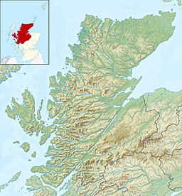
| Coordinates | 57°55.5′N 4°24′W / 57.9250°N 4.400°W |
| Type | Estuary |
| Primary inflows | River Carron, Loch Shin, River Cassley, River Oykel |
| Primary outflows | Dornoch Firth |
| First flooded | January 29, 1892 |
| Settlements | Bonar Bridge, Ardgay, Rosehall, Culrain |
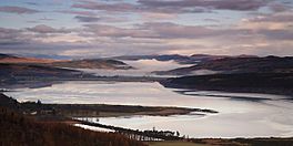
The Kyle of Sutherland (Scottish Gaelic: An Caol Catach) is a special type of river mouth called an estuary. It acts like a natural border, separating the areas of Sutherland and Ross-shire in Scotland. This estuary flows into the Dornoch Firth near a town called Bonar Bridge.
Many rivers feed into the Kyle of Sutherland. These include the Oykel, Shin, River Cassley, and Carron. The Kyle stretches from the famous bridge at Bonar Bridge all the way upstream to where the tide stops flowing, near Rosehall. Locals often just call it 'the Kyle'.
Contents
What is the Kyle of Sutherland?
The Kyle of Sutherland is an important waterway in the Scottish Highlands. It is where fresh river water mixes with salty sea water from the Dornoch Firth. This mix creates a unique environment for many plants and animals.
Where is the Kyle located?
The Kyle of Sutherland is found in the northern part of Scotland. It starts inland near Rosehall and flows towards the sea. Its journey ends at Bonar Bridge, where it joins the wider Dornoch Firth. Several small towns and villages are located along its banks, including Ardgay and Culrain.
How did the Kyle change over time?
For hundreds of years, the Kyle of Sutherland was the official boundary between two old Scottish counties: Sutherland and Ross-shire. However, in 1975, Scotland changed its local government system. The old counties were replaced by new regions and districts.
After these changes, the Kyle became entirely part of the Sutherland area. Even so, many local people still think of it as the traditional border. They remember the way things used to be for centuries.
The Great Flood of 1892
| Date | January 29, 1892 |
|---|
The Kyle of Sutherland has seen many historical events. One of the most famous was a huge flood in 1892. This flood caused a lot of damage, especially to the important bridge at Bonar Bridge.
The First Bonar Bridge
The very first bridge at Bonar Bridge was built in 1812. This was after the famous Battle of Culloden. A very skilled engineer named Thomas Telford designed it. He was famous for building roads, bridges, and canals across Britain. His bridge helped people travel and trade across the Kyle.
The Flood's Impact
Eighty years after it was built, on January 29, 1892, a massive flood swept through the area. This was during a winter when many big floods hit northern Scotland. The powerful waters completely destroyed Thomas Telford's bridge. It was a huge loss for the local communities.
A Prophecy Fulfilled?
Interestingly, some people believe this flood was predicted long before it happened. They say it was foretold by the Brahan Seer. He was a legendary Scottish prophet from the 17th century. People believed he had special powers to see into the future. It's a fascinating local story connected to the Kyle's history.
 | Isaac Myers |
 | D. Hamilton Jackson |
 | A. Philip Randolph |


