
Kāneʻohe Bay facts for kids
Quick facts for kids Kāneʻohe Bay |
|
|---|---|

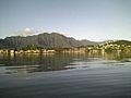
Kāneʻohe Bay on a calm morning viewed from the Kokokahi YWCA at the south end of the bay. Coconut Island appears in the middle of this picture.
|
|
| Lua error in Module:Location_map at line 420: attempt to index field 'wikibase' (a nil value). | |
| Location | Hawaii |
| Type | Bay |
| Max. length | 8 mi (13 km) |
| Max. width | 2.7 mi (4.3 km) |
| Surface area | 45 km2 (17 sq mi) |
| Max. depth | 40 ft (12 m) |
| Islands | 5 |
Kāneʻohe Bay is the biggest sheltered bay in the main Hawaiian Islands. It covers about 45 square kilometers (17 square miles). This beautiful bay is found on the northeast coast of Oʻahu island. Many people enjoy its scenery and use it for fun activities. The largest town near the bay is Kāneʻhe.
.JPG)

Contents
About Kāneʻohe Bay
Kāneʻohe Bay is about 12.8 kilometers (8 miles) long. It is also about 4.3 kilometers (2.7 miles) wide. The bay opens to the ocean with a mouth about 7.4 kilometers (4.6 miles) wide. The deepest part of the bay is about 12 meters (40 feet) deep. This deep area is a channel that was dug out.
Coral Reefs and Channels
Kāneʻohe Bay has one of only two barrier reefs in all of Hawaiʻi. A barrier reef is a long wall of coral that protects the bay from the open ocean. The other barrier reef is near Molokaʻi island. Inside Kāneʻohe Bay, there are many other coral reefs. These reefs are found in a large, calm area called a lagoon.
Two main channels cut through the barrier reef. These channels allow boats to enter and leave the bay. The deeper channel is in the northern part of the bay. It is near Kualoa Regional Park. This channel connects the bay to the North Pacific Ocean.
Mokapu Peninsula
The southern part of the bay is partly surrounded by the Mokapu Peninsula. This peninsula is home to Marine Corps Base Hawaii. It helps to protect the bay's calm waters.

Islands of Kāneʻohe Bay
There are five named islands or small islets within Kāneʻhe Bay.
- Ahu o Laka: This is a sand bar that appears at low tide.
- Kapapa: A small islet on the barrier reef.
- Kekepa: Also known as Turtleback Rock, it's another islet on the barrier reef.
Mokoliʻi Island
Mokoliʻi is often called Chinaman's Hat because of its shape. It is a volcanic island at the northern end of the bay. Long ago, it was the site of an airfield called Kualoa Airfield. The community nearby on the northern side is called Waikane.
Coconut Island
Moku o Loʻe, or Coconut Island, is the largest of the five islands. It is a volcanic island located in the southwest part of the bay. The state of Hawaiʻi owns Coconut Island. It is home to a research lab for the University of Hawaiʻi. You might recognize Coconut Island from the opening of the old TV show Gilligan's Island.
Filming Location
Kāneʻhe Bay is so beautiful that it has been used for movies! In August 2010, parts of the movie "Pirates of the Caribbean: On Stranger Tides" were filmed here.
Bay's Formation
Kāneʻhe Bay was formed from an ancient volcano. It is part of what used to be a huge volcano called the Koʻolau volcano. A very long time ago, a large part of this volcano slid into the Pacific Ocean. This event left behind the Koʻolau Mountain Range and the bay we see today.
Images for kids
-
Koʻolau Mountain Range seen on a clear morning from Kaneʻohe Bay on a boat

