
Lède facts for kids
Quick facts for kids Lède |
|
| River | |
 The Lède river at Casseneuil
|
|
| Country | France |
|---|---|
| Region | Nouvelle-Aquitaine |
| Department | Lot-et-Garonne |
| Communes | Lacapelle-Biron, Gavaudun, Monflanquin, Lédat, Villeneuve-sur-Lot, Casseneuil |
| City | Villeneuve-sur-Lot |
| Source | |
| - location | Blanquefort-sur-Briolance, Lot-et-Garonne, France |
| - elevation | 205 m (673 ft) |
| - coordinates | 44°37′10″N 0°56′22″E / 44.61944°N 0.93944°E |
| Mouth | Lot |
| - location | Casseneuil, Lot-et-Garonne, France |
| - elevation | 40 m (131 ft) |
| - coordinates | 44°26′40″N 0°37′03″E / 44.44444°N 0.61750°E |
| Length | 54.1 km (34 mi) |
| Basin | 411 km² (159 sq mi) |
| Discharge | for Casseneuil |
| - average | 2.23 m³/s (79 cu ft/s) |
The Lède is a river in France, located in the southwest part of the country. It flows through the Lot-et-Garonne department, which is in the Nouvelle-Aquitaine region. The Lède is a smaller river that flows into the Lot river, meaning it's a tributary of the Lot.
Contents
River Facts and Flow
The Lède river is about 54.1 km (33.6 mi) long. This is roughly the distance from one end of a large city to the other. The area of land that drains into the Lède river is called its drainage basin. This basin covers about 440 km2 (170 sq mi).

Water Flow and Seasons
The amount of water flowing in a river is called its discharge. The Lède river's average discharge is about 2.23 m3/s (79 cu ft/s) where it joins the Lot river in Casseneuil.
The river's flow changes throughout the year. It has the most water during winter. In February, the discharge can be as high as 5.38 m3/s (190 cu ft/s). During the drier summer months, like August, the flow drops to about 0.362 m3/s (12.8 cu ft/s).
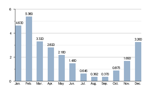
Average monthly water flow (in cubic meters per second) at Casseneuil
River's Journey
The Lède river begins in a place called Capoulèze. This is in the small town, or commune, of Blanquefort-sur-Briolance. The river starts at an elevation of about 205 m (673 ft) above sea level.
As it flows, the Lède generally moves towards the southwest. It passes through several towns in the Lot-et-Garonne department. Some of these towns include:
- Blanquefort-sur-Briolance
- Lacapelle-Biron
- Gavaudun
- Monflanquin
- Lédat (this town is even named after the river!)
- Villeneuve-sur-Lot
- Casseneuil
Finally, the Lède river flows into the Lot river at Casseneuil. This happens at an altitude of about 40 m (131 ft).
Smaller Rivers Joining the Lède
Most of the smaller streams and rivers that flow into the Lède are quite short. These are also called tributaries. Only two of its tributaries are longer than 10 kilometers:
- The Laussou river, which is 13.2 km (8.2 mi) long.
- The Leyze river, which is 12.9 km (8.0 mi) long.
More About Rivers
