La Blanca, Peten facts for kids
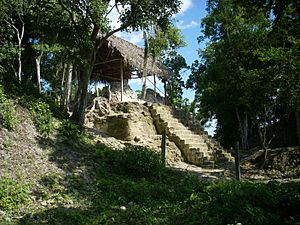
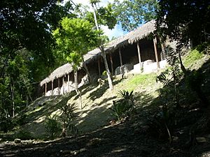
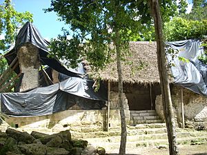
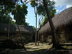
South Group at La Blanca
|
|
| Location | Melchor de Mencos, Petén Department, Guatemala |
|---|---|
| Coordinates | 16°54′13″N 89°26′32″W / 16.90361°N 89.44222°W |
| History | |
| Periods | Late Classic to Early Postclassic |
| Cultures | Maya civilization |
| Site notes | |
| Archaeologists | Cristina Vidal Lorenzo, Gaspar Muñoz Cosme |
| Architecture | |
| Architectural styles | Classic Maya |
| Responsible body: IDAEH | |
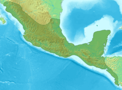
La Blanca is an ancient Maya city. It is located in the northern Petén Department of Guatemala. This site was mainly active during the Middle Preclassic period (900–600 BC). It also saw a lot of activity during the Late Classic period (AD 600–900).
La Blanca was an important administrative center. It had a large palace complex called the acropolis. Unlike some other Maya cities, La Blanca did not focus much on religious ceremonies. It probably served as a border outpost or a trading center. This is because it lacks hieroglyphic texts and carved monuments. It might have been connected to bigger Maya cities like Yaxha or Naranjo.
During the Late Classic period, people could easily access the acropolis. But as conflicts grew, access became very limited. The city's end seems to have been sudden and violent. Archaeologists found signs of a battle when they dug up the acropolis. After the city was abandoned, refugees lived there for a while. They left in the 11th century, and La Blanca was never settled again.
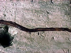
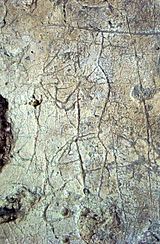
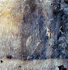
The acropolis buildings have old graffiti. These drawings show people, animals, gods, and palace scenes. There's even graffiti from a Spanish captain who visited in the 1700s.
Contents
Where is La Blanca?
La Blanca is reached by a dirt road. This road is about 17 kilometers (11 miles) long. It connects to the main highway between Flores and Melchor de Mencos. The archaeological site is south of some hills. These hills are about 490 meters (1,600 feet) high.
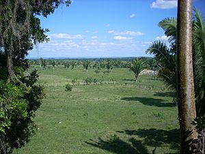
The site is a small forest area surrounded by farms. The land near the ruins is mostly used for raising cattle and horses. La Blanca is close to the Mopan River and the Salsipuedes River. Some areas near the rivers often flood. This might have affected the people who lived there.
At its peak, La Blanca was one of the largest sites of its time. It was on the western Pacific coast. It became a major regional center after Ojo de Agua declined. La Blanca was powerful for about 300 years. Then, Ujuxte, 13 kilometers (8 miles) east, became more important. The site covered over 200 hectares (490 acres). It had some of the earliest large buildings in Mesoamerica.
The forest at the site is about 22 meters (72 feet) tall. It has about 60 types of trees. Important trees include breadnut trees and corozo palms.
History of La Blanca
The first people at La Blanca lived in the South Group. This was during the Early Classic Period. But the city really grew in the Late Classic Period. Public areas were covered with white stucco. The first buildings were put up. The base of the acropolis was built before the Great North Plaza.
In the Late Classic, people could easily go to the acropolis. There were stairways connecting the terraces. But during the Terminal Classic, these stairways were blocked. Many entrances to the acropolis were sealed. Some buildings were completely closed off. This shows that the region was becoming more unstable.
The city's leaders left the acropolis in the Terminal Classic. Most of the city center was also empty. Archaeologists found many flint arrowheads on the acropolis terraces. They also found remains of two people near the surface. This suggests a battle happened when the city was abandoned.
Soon after, at the start of the Postclassic period, refugees moved into the acropolis. These last residents left the city around the 11th century AD. After that, La Blanca was never settled again.
Modern Discoveries
In the 1700s, a Spanish captain named Pedro Montañés visited the site. He left his name and the year 1752 as graffiti. La Blanca was first written about in the early 1900s. In 1905, explorer Teoberto Maler saw buildings there. He called it El Castillito on his map. Raymond E. Merwin visited in 1913. He took photos and renamed it Chac-Ha. At that time, thick plants covered the ruins.
Ian Graham published a map of the site in 1980. The Yaxha-Nakum-Naranjo Project started working there in 1994. They mapped and photographed the ruins. In 1995, they cleared away plants. In 1996, a Guatemalan archaeology unit surveyed the ruins. They recorded damage from looters. From 1997 to 1998, they fixed looting damage. They also supported buildings that might collapse. More work was done in 1999 after an earthquake. The Spanish Ministry of Culture and universities have also funded recent digs. Excavations continued in 2004.
What the Site Looks Like
The site covers about 26 hectares (64 acres). Archaeologists have found many structures. The main buildings are from the Late Classic period. The city's layout is a bit unusual. Its main north-south line points 12 degrees west of north. Most Maya cities point east of north. The political and administrative parts were in the eastern area. This includes the South Group. These areas have better quality buildings.
The Great North Plaza is a large square. It measures 70 by 70 meters (230 by 230 feet). It was leveled with clay mud in the Late Classic Period. This mud probably came from nearby swamps. Digs in the plaza found a retaining wall. This wall was likely part of the large platform supporting the acropolis.
A 30-meter (98-foot) wide causeway runs south from the Plaza. It goes west of the acropolis. This causeway runs about 300 meters (980 feet) to the South Group. West of the causeway are many smaller mounds and platforms. This area was likely a large residential zone.
The area east of the city drops off quickly. It does not have many old buildings. This might be because the Mopan and Salsipuedes rivers often flooded the area.
The Acropolis Palace
The most important complex is the acropolis. This is a palace with a private courtyard. It is located within the Great North Plaza. The acropolis is also called the Quadrangle because of its shape. Terraces lead down from the acropolis to a 1,500 square meter (16,000 sq ft) reservoir. This reservoir was probably a private water source for the palace. It is now dry.
The acropolis was reached by a wide stairway from the Great North Plaza. The shape of the plaza and acropolis is unusual. Similar complexes are found at Tayasal, Ixlú, and Kinal.
Archaeologists found at least two platforms in the acropolis. They were built with finely cut stone blocks. They were covered with good quality stucco floors. Later, these platforms were covered with rough stones and mortar. Then, another stucco floor was added. The two platforms were built in the Late Classic. They were covered over in the Terminal Classic.
The inner courtyard is about 36 meters (118 feet) on each side. The palace completely surrounded it. This made it a very private space. Buildings on the north, west, and south sides faced outwards. They only opened to the courtyard through a central doorway. The eastern building was built later. It had two side doorways. It was the only side that faced directly onto the courtyard. This might have been where the city's ruler lived.
The acropolis had three main entrances. The northern entrance seems to have been the main one. The south entrance was more private. It led to terraces going down to the water source. The western entrance led to a terrace 5 meters (16 feet) above the causeway. This gave a great view of the city.
The acropolis walls are made of high-quality cut stone. They are built with large, finely cut blocks. Some walls are almost 2 meters (7 feet) thick. They are filled with rubble and mortar. The outside of the walls is carefully finished. The inside has good quality vaulted ceilings. This high-quality work is surprising for a smaller site like La Blanca. The walls facing the inner courtyard are very well preserved.
Archaeologists found a 13.5-centimeter (5.3-inch) long flint knife. It was placed inside the north wall on purpose. It weighed 225 grams (7.9 ounces). The knife was in the mortar with the blade pointing out. It had three decorations near the tip. Archaeologists think it was placed there during building rituals.
The outer eastern wall of the acropolis is very well preserved. It has a cornice 3.8 meters (12 feet) above the floor. The wall continued above the cornice for another 3 meters (10 feet). This part probably held a stucco frieze. The entire eastern face was 32 meters (105 feet) long. It stood 12 to 13 meters (39 to 43 feet) above the Great North Plaza. This wall had no doorways or openings.
The buildings on the other sides of the courtyard had many rooms. The rooms were generally about 6 meters (20 feet) high to the top of the vaulting. The inside walls were originally painted red and black. The outside walls were decorated with carved stone friezes. These showed supernatural beings.
The vaulted ceilings of the palace were well built. Their sides were equal in length. This is different from other sites in the Petén region. The vaulting is very high, up to 4 meters (13 feet).
South Range of the Acropolis
The south range is 42 meters (138 feet) long. It separates the courtyard from the terraces to the south. The rooms in the south range have wide benches. They are 0.75 meters (2.5 feet) high. They still have their original stucco covering. The walls are not well preserved. But some parts still have stucco and paint. There is also inscribed graffiti. The wooden beams above the doors were made from sapodilla wood.
Some south-facing rooms have two doorways placed symmetrically. This is very unusual for buildings in the Petén region. Similar architecture is found in the Puuc region of the northern Yucatán Peninsula.
Archaeologists dug south of the south range. They found a well-preserved stucco-covered wall and a stairway. These are thought to be parts of a terrace platform. They also found part of a second terrace wall.
West Group
The West Group was active from the Late Classic to the Terminal Classic. The buildings here were not as well made as those in the acropolis. They used cut limestone blocks with earth-based mortar. The platforms in the West Group likely supported buildings made of wood or other materials that decay. Some of these buildings might have been for making crafts.
The three main plazas of the West Group did not have stucco floors. They were covered with stone chips.
Mound 1 This site had the tallest pyramid in the Pacific Lowlands. It was 25 meters (82 feet) high (Mound 1). It was built around 900 BC. It was one of the first pyramid temples in Mesoamerica. Its base measured 150 by 90 meters (490 by 300 feet).
South Group
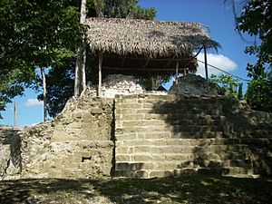
The South Group is the furthest group from the city center. It has large buildings. It is the oldest architectural group at La Blanca. It dates back to the Early Classic. Its orientation is slightly different from the rest of the site. This is likely because it was built earlier. It has several medium-sized mounds. Many of these have been damaged by looters. The larger mounds are pyramids.
One mound is about 9 meters (30 feet) high. It was almost cut in half by a looter's trench. Rescue digs found ceramic remains from the Late Classic. This included a piece with a fragment of hieroglyphic text.
Excavations in 2008 showed that one of these mounds was a temple pyramid. It had a well-preserved central stairway.
Monument 3 Monument 3 is a unique sculpture. It was found in La Blanca Mound 9. This area was likely for elite residents. The sculpture is shaped like a quatrefoil (a four-leaf clover). It was made of rammed earth. Then, it was covered with dark brown clay. The inner edge was painted red. The monument is 2.1 meters (6.9 feet) in diameter.
The La Blanca quatrefoil has a channel in its rim. This channel probably carried water to the inner basin. Experts think the sculpture was used for rituals involving water or fertility. The quatrefoil shape often symbolizes a watery portal to the supernatural world in Maya art. Dating to about 850 BC, this sculpture seems to be the earliest quatrefoil known in Mesoamerica.
The shape and channel suggest Monument 3 was meant to hold liquid. Water would flow into the center. Similar water-filled basins were used in Oaxaca for divination rituals.
Graffiti at La Blanca
The acropolis has a lot of graffiti. It is drawn on the stucco walls inside its rooms. Some of it shows great artistic skill. The graffiti is thought to be from the last time people lived in the acropolis. This was during the Early Postclassic period. It shows local animals and human figures. Some figures are playing musical instruments. Animals shown include a deer, a turtle, and a frog.
Studies of paint traces show that people used local mineral and plant pigments. These might have been collected from the nearby El Camalote hill.
Artefacts Found
Many artefacts found in the acropolis are from the time when the city was abandoned. This was when people from outside the city moved into the empty palace. Digs in the south range of the acropolis found about 11,000 pottery pieces from the Terminal Classic. They also found about 150 pieces from the Early Postclassic. In the same building, 150 stone artefacts were found. Hundreds of waste flint chips were also there.
Fifteen incomplete ceramic figurines were found. These included animal figures and human figures with fancy headdresses. One figurine was an owl-shaped whistle. It was just like another one found in a rubbish heap in the acropolis courtyard. Both whistles are similar to a larger one found at Yaxha.
Other items found include a complete ceramic vessel, a flint knife, and broken figurine pieces. In Room 4, a complete Early Postclassic tripod plate was found. Inside Room 4, more pottery pieces were found. These included 70 from the Terminal Classic and 232 from the Early Postclassic. A greenstone axe was also found. Many Postclassic fragments were from a tripod pitcher. Archaeologists were able to put much of it back together.
Pits in the acropolis courtyard revealed 5,425 ceramic fragments. They also found 22 animal figurine fragments. Stone and shell artefacts, animal bones, and waste flint chips were also present. All these items are from the Terminal Classic.
Analysis of artefacts from La Blanca shows almost no obsidian. But flint of many colors (red, pink, orange, brown, cream, grey) is very common.
Burials
A human burial was found in Room 3 of the acropolis's south range. The remains were lying on their right side, facing west. Their arms were bent. Early studies suggest the remains are of a young adult male. He was about 1.6 meters (5.2 feet) tall. The left side of the skull is deformed. This might be from a condition called oxycephaly or plagiocephaly.
La Blanca Figurines Many hand-made ceramic figurines have been found at La Blanca. Some figurines have puffy faces. These faces are like those seen in the Potbelly sculpture tradition. They also resemble the large heads of the Monte Alto culture. Some figurines have facial features that look like Monte Alto heads. These include closed eyes with puffy lids and swollen cheeks.
See also
 In Spanish: La Blanca (sitio arqueológico) para niños
 | John T. Biggers |
 | Thomas Blackshear |
 | Mark Bradford |
 | Beverly Buchanan |


