La Hourquette d'Ancizan facts for kids
Quick facts for kids La Hourquette d'Ancizan |
|
|---|---|
 |
|
| Elevation | 1,564 m (5,131 ft) |
| Traversed by | D113 |
| Location | Hautes-Pyrénées, France |
| Range | Pyrenees |
| Coordinates | 42°54′01″N 0°18′19″E / 42.90028°N 0.30528°E |
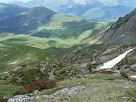
La Hourquette d'Ancizan is a famous mountain pass located in the Pyrenees mountains in France. It's like a special road that goes over a mountain, connecting two valleys. This pass is 1,564 meters (about 5,131 feet) high! It's found in the Hautes-Pyrénées area, between the small towns of Ancizan to the east and Campan to the west.
Contents
What Does 'Hourquette' Mean?
The word hourquette might sound a bit unusual! It's thought to come from an old language called Gascon, which is spoken in that part of France. It's similar to the Spanish word horqueta and the French word fourchette, both meaning 'fork'.
In the mountains of the Hautes-Pyrénées, you'll often see the word hourquette used in the names of other mountain passes. It basically means a 'small pass' or a 'fork in the mountains'.
How to Climb the Pass
There are two main ways to cycle or drive up La Hourquette d'Ancizan, from either side of the mountain.
- From Ancizan: This way is about 10.3 kilometers (6.4 miles) long. It's a tough climb because you go up 805 meters (2,641 feet) in height! The average steepness is 7.8%. The first part is super steep, with some sections going up by 15% – that's like climbing a very steep ramp! But after about 3 kilometers (1.9 miles), it gets a bit easier.
- From Campan: This side is longer, about 22.6 kilometers (14.0 miles). You climb 904 meters (2,966 feet) in total, but it's not as steep on average, only about 4.0%. The steepest part on this side is 10.0%.
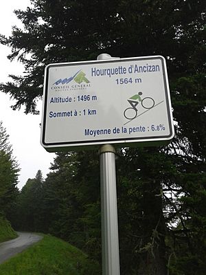
Along both routes, you'll see special signs called mountain pass cycling milestones every kilometer. These signs are very helpful for cyclists! They show you:
- How high the top of the pass is.
- How far you still have to go to reach the top.
- Your current height above sea level.
- How steep the next kilometer will be.
These signs are now common on many big mountain passes in France, both in the Pyrenees and the Alps.
La Hourquette d'Ancizan in the Tour de France
La Hourquette d'Ancizan is a popular climb for the famous Tour de France bicycle race. It's a challenging part of the race that tests the cyclists' strength and endurance.
- 2011 Tour: The pass was first used in the 2011 Tour de France during Stage 12. Laurent Mangel was the first cyclist to reach the top.
- 2013 Tour: It was part of Stage 9 in 2013, a very hilly stage. Dan Martin won that stage.
- 2016 Tour: In 2016, it was featured in Stage 8. Chris Froome won the stage and took the yellow jersey, which means he was leading the race overall.
- 2019 Tour: The pass was included in Stage 12 of the 2019 Tour. Cyclists climbed it after going over another pass called Col de Peyresourde.
- 2022 Tour: Most recently, it was part of Stage 17 in the 2022 Tour. On this day, the cyclists climbed it after the Col d'Aspin.
Here's a quick look at when La Hourquette d'Ancizan has been part of the Tour de France:
| Year | Stage | Category | Start | Finish | Leader at the summit |
|---|---|---|---|---|---|
| 2022 | 17 | 2 | Saint-Gaudens | Peyragudes | |
| 2019 | 12 | 1 | Toulouse | Bagnères-de-Bigorre | |
| 2016 | 8 | 2 | Pau | Bagnères-de-Luchon | |
| 2013 | 9 | 1 | Saint-Girons | Bagnères-de-Bigorre | |
| 2011 | 12 | 1 | Cugnaux | Luz Ardiden |
See also
 In Spanish: Hourquette d'Ancizan para niños
 | Anna J. Cooper |
 | Mary McLeod Bethune |
 | Lillie Mae Bradford |


