
Saint-Girons, Ariège facts for kids
Quick facts for kids
Saint-Girons
|
||
|---|---|---|

View of Saint-Girons and the Sourroque mountain
|
||
|
||
| Country | France | |
| Region | Occitanie | |
| Department | Ariège | |
| Arrondissement | Saint-Girons | |
| Canton | Saint-Girons | |
| Intercommunality | Saint-Girons | |
| Area
1
|
19.13 km2 (7.39 sq mi) | |
| Population
(2012)
|
6,346 | |
| • Density | 331.73/km2 (859.18/sq mi) | |
| Demonym(s) | Saint-Gironnais | |
| Time zone | UTC+01:00 (CET) | |
| • Summer (DST) | UTC+02:00 (CEST) | |
| INSEE/Postal code |
09261 /09200
|
|
| Elevation | 387–1,200 m (1,270–3,937 ft) (avg. 391 m or 1,283 ft) |
|
| Website | www.ville-st-girons.fr | |
| 1 French Land Register data, which excludes lakes, ponds, glaciers > 1 km2 (0.386 sq mi or 247 acres) and river estuaries. | ||
.svg)
Saint-Girons (in the Gascon dialect: Sent Gironç) is a town in southwestern France. It is located in the Ariège area, which is like a county or department. This town used to be the main city of an old French region called Couserans. Couserans forms the western part of the Ariège department.
Contents
History of Saint-Girons

Saint-Girons is not as old as its nearby town, Saint-Lizier. However, there was once a special "sacred forest" in the area where Saint-Girons now stands.
The town gets its name from Saint Girons. He was a saint from the fifth century who helped spread Christianity in southwestern France. People believe that some of his important relics (special objects connected to a saint) were buried in Saint Girons' Church. The town then grew up around this church.
Geography and Location
Saint-Girons is found in a valley at the bottom of the Pyrenees mountains. It's a special place where three rivers meet: the Salat, the Lez, and the Baup. This town is part of the Regional Natural Park Pyrenees Ariégeoises. This park helps protect the beautiful nature of the area.
The town covers an area of about 19.13 square kilometers (about 7.38 square miles). The average height above sea level for the town is 365 meters (about 1,197 feet). At the town hall, the height is 390 meters (about 1,280 feet).
What is the Climate Like in Saint-Girons?
Saint-Girons has an oceanic climate with mild summers. This type of climate is known as Cfb in the Köppen climate classification system. This means it usually has cool winters and warm, but not too hot, summers.
| Climate data for Saint-Girons | |||||||||||||
|---|---|---|---|---|---|---|---|---|---|---|---|---|---|
| Month | Jan | Feb | Mar | Apr | May | Jun | Jul | Aug | Sep | Oct | Nov | Dec | Year |
| Mean daily maximum °C (°F) | 9.9 (49.8) |
11.1 (52.0) |
12.9 (55.2) |
15.0 (59.0) |
18.5 (65.3) |
22.0 (71.6) |
25.0 (77.0) |
24.5 (76.1) |
22.9 (73.2) |
18.8 (65.8) |
13.5 (56.3) |
10.4 (50.7) |
17 (63) |
| Daily mean °C (°F) | 5.1 (41.2) |
6.1 (43.0) |
7.7 (45.9) |
10.1 (50.2) |
13.3 (55.9) |
16.7 (62.1) |
19.4 (66.9) |
19.0 (66.2) |
17.0 (62.6) |
13.1 (55.6) |
8.3 (46.9) |
5.5 (41.9) |
11.8 (53.2) |
| Mean daily minimum °C (°F) | 0.3 (32.5) |
1.1 (34.0) |
2.6 (36.7) |
5.1 (41.2) |
8.1 (46.6) |
11.5 (52.7) |
13.7 (56.7) |
13.6 (56.5) |
11.1 (52.0) |
7.5 (45.5) |
3.1 (37.6) |
0.7 (33.3) |
6.5 (43.7) |
| Average precipitation mm (inches) | 92.5 (3.64) |
78.3 (3.08) |
92.9 (3.66) |
98.3 (3.87) |
108.8 (4.28) |
90.0 (3.54) |
62.4 (2.46) |
74.0 (2.91) |
73.2 (2.88) |
77.5 (3.05) |
77.2 (3.04) |
88.3 (3.48) |
1,013.4 (39.90) |
| Source: Metereological data for Saint-Girons - Antichan from 1961 to 1990 July 2013 | |||||||||||||
Population of Saint-Girons
_-_%C3%89glise_Saint-Girons_-_20070625.jpg)
As of 2012, Saint-Girons had a population of 6,346 people. This makes it the most populated subprefecture in its department. The population density is about 332 inhabitants per square kilometer. This means that for every square kilometer, there are about 332 people living there.
People from Saint-Girons are called Saint-Gironnais or Gironnais in French. For women, they are called Saint-Gironnaises or Gironnaises.
What to See in Saint-Girons
If you visit Saint-Girons, here are some important buildings and places you might want to see:
- The Saint-Girons church
- The Saint-Valier church
- The Palais de Justice (which is like a courthouse)
Sister Cities Around the World
Saint-Girons has special friendships with other cities in different countries. These are called "sister cities" or "twin towns."
Related Information
Images for kids
-
Funerary cippus to a Pompeia
-
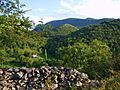
Countryside
-
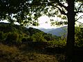
Countryside
.jpg)
.jpg)
.jpg)
See also
 In Spanish: Saint-Girons (Ariège) para niños
