
Ariège facts for kids
Quick facts for kids
Ariège
|
|||
|---|---|---|---|

The castle of Foix, Ariège.
|
|||
|
|||

Location of Ariège in France
|
|||
| Country | France | ||
| Region | Occitanie | ||
| Prefecture | Foix | ||
| Subprefectures | Pamiers Saint-Girons |
||
| Area | |||
| • Total | 4,889.9 km2 (1,888.0 sq mi) | ||
| Population
(2013)
|
|||
| • Total | 152,684 | ||
| • Rank | 95th | ||
| • Density | 31.2244/km2 (80.8707/sq mi) | ||
| Demonym(s) | Ariègeois, Ariègeoise | ||
| Time zone | UTC+1 (CET) | ||
| • Summer (DST) | UTC+2 (CEST) | ||
| ISO 3166 code | FR-09 | ||
| Arrondissements | 3 | ||
| Cantons | 13 | ||
| Communes | 332 | ||
| Website | www.ariege.fr | ||


Ariège (pronounced ah-ree-EHZH) is a special area in southern France. It's called a department and is part of the Occitanie region. The department gets its name from the Ariège river, which flows right through it.
Ariège is surrounded by other French departments like Haute-Garonne and Aude. To the south, it shares borders with Spain and the small country of Andorra.
Contents
History of Ariège
Ancient Times and Early Settlements
People have lived in Ariège for a very long time, even in prehistoric times! We know this because there are caves with amazing cave paintings and ancient stone structures called dolmens.
Later, Basque people settled here. They lived on the northern side of the Pyrenees mountains and in the valleys. Around the year 415, Ariège became part of the kingdom of the Visigoths. But in 507, the king of the Franks defeated them.
How Ariège Became a Department
Ariège was officially created in 1790 during the French Revolution. At that time, all of France was divided into departments, replacing the older provinces. Ariège was formed by joining two older areas: the counties of Foix and Couserans.
Geography of Ariège
Ariège is part of the Occitanie region and covers an area of about 4,890 square kilometers (1,888 square miles). The main city, or capital, is Foix. It has about 9,731 people. However, the largest city in Ariège is Pamiers, with about 15,744 people.
Natural Areas of Ariège
Ariège has three main types of natural landscapes:
- The Ariège Plain: This is the northern part of the department. It has flat lands, small hills, and low valleys. Agriculture is very important here. Two big rivers, the Ariège and the Lèze, flow through this plain.
- The Pyrenean Foothills: This area includes smaller mountains and hills that are less than 1,000 meters (3,280 feet) high.
- The Ariège High Country: This part is dominated by the tall Pyrenees mountains. These mountains are higher than 1,000 meters (3,280 feet) above sea level and form the border between France and Spain.
The highest mountain in Ariège is the Pica d'Estats, which is 3,143 meters (10,312 feet) tall. It's right on the border with Spain. Other tall mountains include the peak of Montcalm (3,077 m) and the Pic de Sotllo (3,072 m).
The main river is the Ariège river, which flows into the Garonne river. The Lèze river is another important river that joins the Ariège.
Climate in Ariège
Ariège has two main types of weather:
- Mediterranean: This climate is found in the foothills and the Ariège river valley. You can see it in the types of plants that grow there.
- Continental: This climate is found in the Pyrenean valleys. It often has many storms and big differences between daytime and nighttime temperatures.
Temperatures are usually mild in the lower areas. For example, in Foix (which is about 400 meters high), the average temperature is 5 °C (41 °F) in January and 19 °C (66 °F) in July. But as you go higher, it gets colder quickly. In l'Hospitalet-près-l'Andorre (1,430 meters high), it's 0 °C (32 °F) in January and 14 °C (57 °F) in July.
| Climate data for Saint-Girons | |||||||||||||
|---|---|---|---|---|---|---|---|---|---|---|---|---|---|
| Month | Jan | Feb | Mar | Apr | May | Jun | Jul | Aug | Sep | Oct | Nov | Dec | Year |
| Mean daily maximum °C (°F) | 9.9 (49.8) |
11.1 (52.0) |
12.9 (55.2) |
15.0 (59.0) |
18.5 (65.3) |
22.0 (71.6) |
25.0 (77.0) |
24.5 (76.1) |
22.9 (73.2) |
18.8 (65.8) |
13.5 (56.3) |
10.4 (50.7) |
17 (63) |
| Daily mean °C (°F) | 5.1 (41.2) |
6.1 (43.0) |
7.7 (45.9) |
10.1 (50.2) |
13.3 (55.9) |
16.7 (62.1) |
19.4 (66.9) |
19.0 (66.2) |
17.0 (62.6) |
13.1 (55.6) |
8.3 (46.9) |
5.5 (41.9) |
11.8 (53.2) |
| Mean daily minimum °C (°F) | 0.3 (32.5) |
1.1 (34.0) |
2.6 (36.7) |
5.1 (41.2) |
8.1 (46.6) |
11.5 (52.7) |
13.7 (56.7) |
13.6 (56.5) |
11.1 (52.0) |
7.5 (45.5) |
3.1 (37.6) |
0.7 (33.3) |
6.5 (43.7) |
| Average precipitation mm (inches) | 92.5 (3.64) |
78.3 (3.08) |
92.9 (3.66) |
98.3 (3.87) |
108.8 (4.28) |
90.0 (3.54) |
62.4 (2.46) |
74.0 (2.91) |
73.2 (2.88) |
77.5 (3.05) |
77.2 (3.04) |
88.3 (3.48) |
1,013.4 (39.90) |
| Average precipitation days (≥ 1 mm) | 11.4 | 10.6 | 12.2 | 13.0 | 13.2 | 9.5 | 7.6 | 9.1 | 8.4 | 8.9 | 9.8 | 11.0 | 124.7 |
| Mean monthly sunshine hours | 113.6 | 123.7 | 160.8 | 157 | 180.3 | 195.2 | 227.8 | 205.4 | 199.9 | 173.6 | 127.4 | 107.4 | 1,972 |
| Source: Metereological data for Saint-Girons - Antichan from 1961 to 1990 July 2013 | |||||||||||||
How Ariège is Governed
The department of Ariège is managed by the General Council of the Ariège. This council is located in Foix. Ariège is part of the larger Occitanie region in France.
Administrative Divisions
Ariège is divided into smaller areas to help with its administration.
- There are 3 arrondissements (which are like large districts).
- It has 13 cantons (smaller administrative areas).
- There are 332 communes (which are like municipalities or towns/villages).
| INSEE code |
Arrondissement | Capital | Population (2013) |
Area (km²) |
Density (Inh./km²) |
Communes |
|---|---|---|---|---|---|---|
| 091 | Foix | Foix | 51,738 | 2,078 | 24.9 | 135 |
| 092 | Pamiers | Pamiers | 73,491 | 1,315 | 55.9 | 115 |
| 093 | Saint-Girons | Saint-Girons | 27,455 | 1,497 | 18.3 | 82 |
-
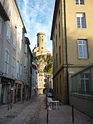
The "old city" of Foix.
-
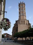
The Cathedral of Saint-Antonin in Pamiers.
-
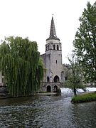
Saint-Girons' Church by the Salat river.

.JPG)
_-_%C3%89glise_Saint-Girons_-_20070625.jpg)
Here is a list of the 13 cantons in Ariège, which were reorganized in March 2015:
- Arize-Lèze
- Couserans Est
- Couserans Ouest
- Foix
- Haute-Ariège
- Mirepoix
- Pamiers-1
- Pamiers-2
- Pays d'Olmes
- Portes d'Ariège
- Portes du Couserans
- Sabarthès
- Val d'Ariège
Population of Ariège
In 2013, Ariège had 152,684 people living there. This means there were about 31 people per square kilometer (80 people per square mile). The arrondissement of Pamiers has the most people, with 73,491 residents. Foix has 51,738, and Saint-Girons has 27,455.
About a quarter of all the people in Ariège live in just four communes that have 6,000 or more inhabitants. People from Ariège are called ariègeois (for men) or ariègeoises (for women) in French.
Economy of Ariège
Farming and Resources
Agriculture is an important activity in Ariège. However, only a small part of the land is used for farming, about 27% of the total area.
The Ariège plain is the most fertile area. Here, farmers grow crops like maize, wheat, and sunflower. Other natural regions are not as good for farming. Instead, they are covered with forests or used as pastures for animals like sheep, cattle, and horses.
In the Ax valleys, mining for talc is a key activity. This industry is also supported by tourism, especially for winter sports in the mountains.
Energy Production
Ariège also produces a lot of hydroelectric power, which is electricity made from water. About one-fifth of all the hydroelectric power in the Pyrenees comes from Ariège. The hydroelectric plant at Aston produces the most electricity each year in the Pyrenees.
See Also
Images for kids


.jpg)

