La Verkin, Utah facts for kids
Quick facts for kids
La Verkin, Utah
|
|
|---|---|

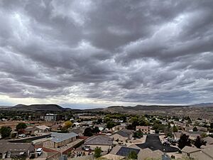
La Verkin in 2023
|
|

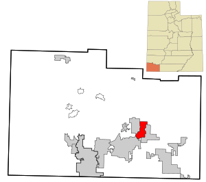
Location in Washington County and the state of Utah
|
|
| Country | United States |
| State | Utah |
| County | Washington |
| Settled | 1897 |
| Incorporated | 1927 |
| Founded by | Thomas Judd |
| Named for | Spanish: La Virgen: 'The Virgin' |
| Area | |
| • Total | 12.78 sq mi (33.10 km2) |
| • Land | 12.78 sq mi (33.10 km2) |
| • Water | 0.00 sq mi (0.00 km2) |
| Elevation | 3,816 ft (1,163 m) |
| Population
(2010)
|
|
| • Total | 4,060 |
| • Density | 347.86/sq mi (134.31/km2) |
| Time zone | UTC-7 (Mountain (MST)) |
| • Summer (DST) | UTC-6 (MDT) |
| ZIP code |
84745
|
| Area code(s) | 435 |
| FIPS code | 49-43440 |
| GNIS feature ID | 2411583 |
La Verkin is a city located in Washington County, Utah, in the United States. In 2010, about 4,060 people lived there. This was more than the 3,392 people who lived there in 2000.
Contents
History of La Verkin
The name La Verkin might come from the Spanish words la virgen, which means 'the virgin'. This could be because of the nearby Virgin River. Another idea is that the name came from a mistake when writing down 'beaver skin'.
In 2001, La Verkin's City Council made a special rule. They declared the city a "United Nations-free zone". This meant the city would not follow rules or programs from the United Nations. The United Nations is an international organization that tries to promote peace and cooperation around the world.
Geography and Climate
La Verkin covers an area of about 16.1 square miles (41.8 square kilometers). All of this area is land.
Climate in La Verkin
La Verkin has a semi-arid climate. This means it is usually dry, but not a complete desert. It gets some rain, but not a lot.
| Climate data for La Verkin, Utah | |||||||||||||
|---|---|---|---|---|---|---|---|---|---|---|---|---|---|
| Month | Jan | Feb | Mar | Apr | May | Jun | Jul | Aug | Sep | Oct | Nov | Dec | Year |
| Record high °F (°C) | 74 (23) |
80 (27) |
93 (34) |
97 (36) |
106 (41) |
111 (44) |
114 (46) |
111 (44) |
108 (42) |
103 (39) |
85 (29) |
74 (23) |
114 (46) |
| Mean daily maximum °F (°C) | 52.2 (11.2) |
57.1 (13.9) |
65.5 (18.6) |
72.8 (22.7) |
82.5 (28.1) |
93.5 (34.2) |
98.3 (36.8) |
96.4 (35.8) |
89.3 (31.8) |
75.9 (24.4) |
61.6 (16.4) |
50.8 (10.4) |
74.7 (23.7) |
| Mean daily minimum °F (°C) | 29.1 (−1.6) |
33.3 (0.7) |
39.8 (4.3) |
44.2 (6.8) |
52.2 (11.2) |
60.9 (16.1) |
67.6 (19.8) |
67.2 (19.6) |
59.3 (15.2) |
47.2 (8.4) |
34.8 (1.6) |
28.1 (−2.2) |
47.0 (8.3) |
| Record low °F (°C) | −2 (−19) |
2 (−17) |
10 (−12) |
21 (−6) |
23 (−5) |
34 (1) |
46 (8) |
39 (4) |
31 (−1) |
17 (−8) |
12 (−11) |
1 (−17) |
−2 (−19) |
| Average precipitation inches (mm) | 1.43 (36) |
1.81 (46) |
1.43 (36) |
0.77 (20) |
0.46 (12) |
0.20 (5.1) |
0.61 (15) |
0.96 (24) |
0.93 (24) |
0.99 (25) |
0.86 (22) |
1.19 (30) |
11.64 (296) |
| Average snowfall inches (cm) | 0.3 (0.76) |
0.4 (1.0) |
0.2 (0.51) |
0 (0) |
0 (0) |
0 (0) |
0 (0) |
0 (0) |
0 (0) |
0 (0) |
0 (0) |
0.5 (1.3) |
1.4 (3.6) |
| Source: NOAA | |||||||||||||
People of La Verkin
| Historical population | |||
|---|---|---|---|
| Census | Pop. | %± | |
| 1910 | 120 | — | |
| 1920 | 173 | 44.2% | |
| 1930 | 236 | 36.4% | |
| 1940 | 349 | 47.9% | |
| 1950 | 387 | 10.9% | |
| 1960 | 365 | −5.7% | |
| 1970 | 463 | 26.8% | |
| 1980 | 1,174 | 153.6% | |
| 1990 | 1,771 | 50.9% | |
| 2000 | 3,392 | 91.5% | |
| 2010 | 4,060 | 19.7% | |
| 2019 (est.) | 4,446 | 9.5% | |
| U.S. Decennial Census | |||
In 2000, there were 3,392 people living in La Verkin. There were 1,053 households and 840 families. A household means all the people living in one home. The city had about 210 people per square mile.
Many homes had children under 18 living there, about 44.6%. Most households, 66.3%, were married couples living together. About 9.6% of homes had a female head of household with no husband.
The average age of people in La Verkin was 29 years old. About 35.8% of the population was under 18. About 13.1% of people were 65 years old or older.
The average income for a household in the city was $35,949. For families, the average income was $39,432. About 12.1% of all people in La Verkin lived below the poverty line. This included 15.7% of those under 18.
See also
 In Spanish: La Verkin (Utah) para niños
 | James B. Knighten |
 | Azellia White |
 | Willa Brown |

