
Lac aux Araignées facts for kids
Quick facts for kids Lac aux Araignées |
|
|---|---|

Lac aux Araignées et Montagnes environnantes
|
|

Lac aux Araignées
Location in Quebec
|
|
| Location | Canada, Quebec, Estrie, Le Granit Regional County Municipality |
| Coordinates | 45°28′29″N 70°48′46″W / 45.47472°N 70.81277°W |
| Primary outflows | Rivière aux Araignées |
| Catchment area | 23.2 kilometres (14.4 mi) |
| Max. length | 5.5 kilometres (3.4 mi) |
| Max. width | 3.9 kilometres (2.4 mi) |
| Surface area | 8.72 kilometres (5.42 mi) |
| Surface elevation | 406 metres (1,332 ft) |
| Frozen | Surface of the lake is generally frozen from mid-December to mid-March |
Lac aux Araignées (which means Spider Lake in English) is a lake in Quebec, Canada. It is located in the town of Frontenac. This lake is part of the Le Granit Regional County Municipality area.
Contents
Geography of Lac aux Araignées
This lake is quite large, covering about 8.72 kilometres (5.42 mi) of water. Imagine a lake that's about 5.5 kilometres (3.4 mi) long and 3.9 kilometres (2.4 mi) wide! Its edge, or perimeter, stretches for about 23.2 kilometres (14.4 mi).
The lake sits at an elevation of 406 metres (1,332 ft) above sea level. The area that collects water for the lake, called its catchment area, is about 150 kilometres (93.21 mi). Part of the Zec Louise-Gosford is located close to the lake.
Many rivers flow into Lac aux Araignées. The main ones are the rivière aux Araignées, the rivière des Indiens, and Meads Creek. Meads Creek gets its water from smaller streams. These streams come from the sides of several mountains.
Some of these mountains are Moose Hill (888 metres (2,913 ft)), Mount Merrill (997 metres (3,271 ft)), Mount Caribou (1,110 metres (3,640 ft)), Mount Pisgah (1,023 metres (3,356 ft)), and Mont Louise (755 metres (2,477 ft)). These mountains form a valley that feeds the lake. The water from Lac aux Araignées then flows into lac des Joncs (Mégantic). This pond is next to a swampy area south of Lac Mégantic.
Why is it Called Spider Lake?
This lake got its name because of its unique shape. It has many small bays and points that make it look a bit like a spider! The south side of the lake is mostly smooth. But the north side has four big bays. These are Clarke Bay, Boyle Bay, the bay of the rivière des Indiens, and another one further east. Three pieces of land stick out, separating these bays.
The word "spiders" was also used for a river and an island nearby.
Long ago, in 1775, American soldiers tried to cross this area. They found it very difficult because of the swamps and tough banks. Old documents from that time called the lake "nepis." This word means pond, lake, or swamp.
Later, in 1795, a map by Gale and Duberger called it "Mecanicamack L." In 1815, a mapmaker named Joseph Bouchette changed it to Macanamack. These names come from the Abenakis language. They also mean "marshy lake."
In the early 1800s, people surveying the land noticed the lake's special shape. This inspired them to call it "Spider Lake."
The French name, "Lac aux Araignées," became common in the 1920s. It was officially recognized on December 5, 1968, by the Commission de toponymie du Québec.
Megantic Fish and Game Corporation
.jpg)
In 1887, a group called the Megantic Fish and Game Corporation was started. This was a large club for hunting and fishing. It included a huge area, even parts of Lac Mégantic and some of Maine.
In the small village of Trois-Lacs, there was a road. This road led to a steamer boat called Lena, which took people across Lac Mégantic. Another small steamboat on Lac aux Araignées carried travelers to the Macannamac Hotel. This was a big, three-story building with a large hall and a huge fireplace. Guides were available there to help people with hunting and fishing. The club had about 250 members, and they could also rent cabins.
In 1914, the lake was listed as "Spider" in a dictionary of Quebec's rivers and lakes. The French name "Lac aux Araignées" became official later.
Fauna
You can find several types of fish in Lac aux Araignées. These include smallmouth bass, perch, rainbow trout, and speckled trout.
Images for kids
-
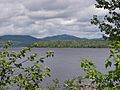
Lac Aux Araignées, public access point route 161. Mount Flat Top (830 meters) on the left; and Merrill (997 meters) in the center, background.
-
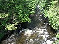
Décharge du lac aux Araignées, between the lake and Route 161 bridge.
-
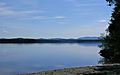
Lac aux Araignées in rang 4 in Frontenac.
-
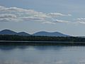
Lac aux Araignées in rang 4.
.JPG)


