Mount Pisgah (Quebec) facts for kids
Quick facts for kids Mount Pisgah |
|
|---|---|

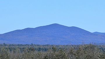
View of Mont Pisgah, from rang Saint-Joseph, in Nantes.
|
|
| Highest point | |
| Peak | 1,023 metres (3,356 ft) |
| Parent peak | White Mountains (Appalachian Mountains) |
| Geography | |
| Location | Estrie Franklin County |
| Country | Canada États-Unis |
| Province U.S. state |
Québec Maine |
| Region | Region County |
Mount Pisgah (also known as Mont Pisgah in French) is a mountain that sits right on the border between two countries! It's located partly in the Canadian province of Quebec and partly in the American state of Maine. This mountain is part of the larger Appalachian Mountains range. It stands tall at about 1,023 meters (which is roughly 3,356 feet) above sea level.
Where is Mount Pisgah?
Mount Pisgah is found in a beautiful area. Part of it is in a town called Saint-Augustin-de-Woburn in Quebec. It's also southeast of a lake known as lac aux Araignées. What makes this mountain special is that the Canada–United States border actually crosses right over it!
On the southern side, the mountain slopes down towards a group of lakes called the Chaîne des Lacs, which means Chain of Ponds. A river called the Dead River flows through this chain of ponds.
What's in a Name?
The name "Mont Pisgah" was officially recognized on December 5, 1968. This was done by the Commission de toponymie du Québec, which is a group in Quebec responsible for naming places.
 | William L. Dawson |
 | W. E. B. Du Bois |
 | Harry Belafonte |


