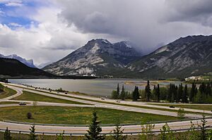
Lac des Arcs, Alberta facts for kids
Quick facts for kids
Lac des Arcs
|
|
|---|---|

|
|
| Country | Canada |
| Province | Alberta |
| Census division | No. 15 |
| Municipal district | M.D. of Bighorn No. 8 |
| Government | |
| • Type | Unincorporated |
| Area
(2021)
|
|
| • Land | 0.57 km2 (0.22 sq mi) |
| Elevation | 1,320 m (4,330 ft) |
| Population
(2021)
|
|
| • Total | 146 |
| • Density | 256.2/km2 (664/sq mi) |
| Time zone | UTC−7 (MST) |
| • Summer (DST) | UTC−6 (MDT) |
Lac des Arcs is a small community, known as a hamlet, in Alberta, Canada. It is part of the Municipal District (MD) of Bighorn No. 8. The hamlet is located on the south side of the Bow River, across from another community called Exshaw. It sits at an elevation of about 1,320 meters (4,331 feet) above sea level. Highway 1, also known as the Trans-Canada Highway, runs along the south side of Lac des Arcs.
This hamlet is found in Census Division No. 15 and is part of the federal voting area called Wild Rose.
The Lake and Its Uses
The wide part of the Bow River next to the Hamlet of Lac des Arcs is also called a lake, sharing the same name. This lake is a popular spot for outdoor activities. Many people come here for wind surfing when the conditions are right. It's also a good place for fishing.
On the northern shore of the lake, you'll find the Lafarge Exshaw Plant. This plant is a limestone quarry, which means it's a place where limestone rock is dug out of the ground.
People Living Here
Lac des Arcs is a small community with a changing population. In the 2021 Census, 146 people lived in Lac des Arcs. These residents lived in 57 of the 82 available homes. This number was a bit higher than in 2016.
In the 2016 Census, 130 people lived in Lac des Arcs. They lived in 53 out of 83 homes. The area of the hamlet is about 0.57 square kilometers (0.22 square miles).
 | Isaac Myers |
 | D. Hamilton Jackson |
 | A. Philip Randolph |


