
Ladonia, Texas facts for kids
Quick facts for kids
Ladonia, Texas
|
|
|---|---|
 |
|

Location of Ladonia, Texas
|
|
 |
|
| Country | United States |
| State | Texas |
| County | Fannin |
| Area | |
| • Total | 1.99 sq mi (5.16 km2) |
| • Land | 1.99 sq mi (5.16 km2) |
| • Water | 0.00 sq mi (0.00 km2) |
| Elevation | 643 ft (196 m) |
| Population
(2020)
|
|
| • Total | 597 |
| • Density | 300.0/sq mi (115.70/km2) |
| Time zone | UTC-6 (Central (CST)) |
| • Summer (DST) | UTC-5 (CDT) |
| ZIP code |
75449
|
| Area code(s) | 903 |
| FIPS code | 48-40180 |
| GNIS feature ID | 2412858 |
Ladonia is a small town located in Fannin County, Texas, United States. It is a quiet place with a rich history. In 2020, about 597 people called Ladonia home.
Contents
A Look Back: Ladonia's History
The area where Ladonia now stands was first settled around 1840. It was originally known as McCownville.
How Ladonia Got Its Name
In 1857, the town's name was changed to Ladonia. People believe it was named in honor of a person called A. T. Donitz.
Growth and Change in Ladonia
Ladonia grew quite a bit in the late 1800s. This happened when the Gulf Colorado Santa Fe Railroad built tracks through the town. Ladonia became an important place for shipping crops like corn, cotton, and grain.
Because of the railroad, Ladonia's population quickly grew to 1,500 people in the 1890s. It reached its highest point with over 2,000 residents by the early 1900s.
Challenges and Population Decline
However, Ladonia faced hard times during the Great Depression. After this period, the population dropped to 1,199 and never fully recovered. The number of people living in Ladonia continued to decrease over the years. By 1990, it was 658, and by 2010, it was 612.
Exploring Ladonia's Geography
Ladonia is found in the southeastern part of Fannin County.
Major Roads in Ladonia
Texas State Highway 34 goes through the town. If you drive north on this highway, you'll reach Honey Grove in about 12 miles. Going southwest for about 10 miles will take you to Wolfe City. Another road, Texas State Highway 50, leads south from Ladonia to Commerce, which is about 14 miles away.
Ladonia Fossil Park Location
A very interesting spot, the Ladonia Fossil Park, is located about 2 miles north of town. It sits along the North Sulphur River.
Ladonia's Land Area
According to the United States Census Bureau, Ladonia covers a total area of about 5.2 square kilometers (or 1.99 square miles). All of this area is land.
Who Lives in Ladonia: Demographics
The population of Ladonia has changed over many years. Here's a look at how many people have lived there during different census counts:
| Historical population | |||
|---|---|---|---|
| Census | Pop. | %± | |
| 1870 | 516 | — | |
| 1880 | 223 | −56.8% | |
| 1890 | 765 | 243.0% | |
| 1900 | 1,409 | 84.2% | |
| 1910 | 1,293 | −8.2% | |
| 1920 | 1,713 | 32.5% | |
| 1930 | 1,199 | −30.0% | |
| 1940 | 1,279 | 6.7% | |
| 1950 | 1,104 | −13.7% | |
| 1960 | 890 | −19.4% | |
| 1970 | 757 | −14.9% | |
| 1980 | 761 | 0.5% | |
| 1990 | 658 | −13.5% | |
| 2000 | 667 | 1.4% | |
| 2010 | 612 | −8.2% | |
| 2020 | 597 | −2.5% | |
| U.S. Decennial Census | |||
Ladonia's Population in 2020
The 2020 United States census counted 597 people living in Ladonia. There were 304 households and 219 families in the town.
The table below shows the different racial groups that make up Ladonia's population, based on the 2020 census. NH means "Non-Hispanic."
| Race | Number | Percentage |
|---|---|---|
| White (NH) | 344 | 57.62% |
| Black or African American (NH) | 183 | 30.65% |
| Native American or Alaska Native (NH) | 12 | 2.01% |
| Asian (NH) | 2 | 0.34% |
| Mixed/Multi-Racial (NH) | 38 | 6.37% |
| Hispanic or Latino | 18 | 3.02% |
| Total | 597 |
Learning in Ladonia: Education
Students in Ladonia attend schools that are part of the Fannindel Independent School District.
Fun in Ladonia: Parks and Recreation
One of the most exciting places in Ladonia is the Ladonia Fossil Park.
Discovering Fossils at Ladonia Park
The Ladonia Fossil Park is a popular spot for both serious fossil hunters and people just looking for a fun adventure. Visitors often find amazing things like shark teeth and even bones from ancient sea creatures called Mosasaurs. In 2021, the park had to move temporarily because of construction work.
Images for kids
-
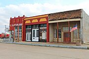
Downtown Ladonia
-

City Hall
-
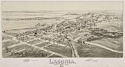
Map of the city 1891


See also
 In Spanish: Ladonia (Texas) para niños
