Lake Forsyth facts for kids
Quick facts for kids Lake ForsythWairewa |
|
|---|---|

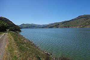
Lake Forsyth from the Little River Rail Trail
|
|
| Location | Canterbury, South Island |
| Coordinates | 43°48′18″S 172°44′27″E / 43.8050°S 172.7407°E |
| Primary inflows | Takiritawai River |
| Primary outflows | seepage, artificial opening |
| Basin countries | New Zealand |
| Max. length | 7.6 km (4.7 mi) |
| Max. width | 1 km (0.62 mi) |
| Surface area | 627.5526 ha (1,550.716 acres) |
| Average depth | 1 m (3 ft 3 in) |
| Surface elevation | 0 m (0 ft) |
| Settlements | Little River |
Lake Forsyth (known to Māori as Te Roto o Wairewa) is a lake in the Canterbury area of New Zealand. It is located on the South Island.
This lake is fed by the Takiritawai River. Water from the lake then flows out through a gravel bank into the sea. This happens near the small town of Birdlings Flat.
State Highway 75 runs along the north-western side of the lake. This road leads to Akaroa. Part of the Little River Rail Trail also follows the lake's shore. Another important lake, Lake Ellesmere / Te Waihora, is very close by.
Contents
Discovering Lake Forsyth
Lake Forsyth is an important natural feature in the Canterbury region. It is known for its long, narrow shape.
Where is Lake Forsyth?
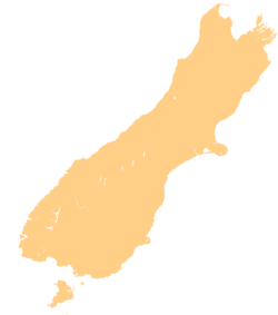
Lake Forsyth is found on the eastern side of the South Island of New Zealand. It sits between the hills and the coast. The nearby town of Little River is a small community close to the lake.
How the Lake Works
The lake gets its water from the Takiritawai River. This river is a short branch of the Okuti River. The water then leaves the lake by soaking into the ground or through an artificial opening. This opening allows water to flow into the sea.
A Special Place for Māori People
Lake Forsyth, or Te Roto o Wairewa, has a deep history and meaning for the Māori. It was especially important to the Ngāi Tahu tribe.
Wairewa: A Customary Lake
For the Ngāi Tahu tribe, Wairewa was a vital source of food. They especially relied on tuna (eels) from the lake. It is the only lake that is considered a "customary lake" for the Ngāi Tahu. This means it has special traditional rights and importance for them. The Wairewa Runanga, which is one of the 18 Ngāi Tahu Runanga (local tribal councils), acts as the kaitiaki (guardians) of the lake. They work to protect it.
Protecting Lake Forsyth's Water
Over time, the water quality in Lake Forsyth has become a big concern. This has been happening since the early 1900s.
Why the Water Quality Changed
One major reason for the lake's problems is the cutting down of trees around it. This is called deforestation. When trees are removed, the soil can wash away easily. This leads to erosion and a lot of dirt and mud flowing into the lake. This process is called silting. It makes the lake shallower and affects its health.
What are Algal Blooms?
Lake Forsyth is known as a hypertrophic lake. This means it has too many nutrients in its water. This leads to a problem called eutrophication. When there are too many nutrients, tiny water plants called algae can grow very quickly. This creates thick, green layers on the water's surface, known as algal blooms.
These blooms can make the water toxic. In 2016, after a period of dry weather, the water quality got much worse. The toxic algal blooms caused harm to animals. Some pets and farm animals, like sheep, became sick and died after drinking the water.
Working Towards Cleaner Water
People have tried to fix the lake's water quality. One way is by opening the lake up to the ocean. This helps to flush out some of the bad water. However, these efforts have only had limited success so far. Work continues to find better ways to protect and improve Lake Forsyth.
 | Leon Lynch |
 | Milton P. Webster |
 | Ferdinand Smith |


