
Lake George (New South Wales) facts for kids
Quick facts for kids Lake George |
|
|---|---|

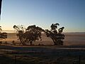
Part of Lake George in 2020 after it was partially filled by several days of rain
|
|

Lake George
Location in New South Wales
|
|
| Location | New South Wales |
| Coordinates | 35°10′S 149°25′E / 35.167°S 149.417°E |
| Lake type | Intermittent |
| Primary outflows | evaporation |
| Basin countries | Australia |
| Max. length | 25 km (16 mi) |
| Max. width | 10 km (6.2 mi) |
| Average depth | 1 metre (3 ft 3 in) |
| Max. depth | 7.5 m (25 ft) |
| Surface elevation | 654 m (2,146 ft) |
Lake George is a special lake in south-eastern New South Wales, Australia. It is also known by its Aboriginal names, Weereewa or Ngungara, from the Ngunnawal language. This lake is about 40 kilometres (25 mi) north-east of Canberra. You can see it next to the Federal Highway if you are driving towards Goulburn and Sydney. The area around the lake is also called Lake George.
Contents
About Lake George
Lake George is an endorheic lake. This means it's a lake that doesn't flow out into rivers or oceans. Water only leaves the lake by sinking into the ground or by evaporation (turning into vapor and going into the air).
Scientists believe the lake is more than a million years old. Long ago, small streams used to flow from this area into the Yass River. But then, the Lake George Escarpment (a steep slope) formed because of big movements in the Earth's crust. This blocked the water flow, creating the lake. In past Ice Ages, Lake George was much bigger and deeper than it is today.
Underneath the lake, there is more than 250 metres (820 ft) of sediment (layers of dirt and rock). The oldest parts of this sediment are about 4 to 5 million years old.
Lake George is about 25 km (16 mi) long and 10 km (6.2 mi) wide. It is mostly flat and very shallow. Its depth can change a lot, from 1.5–4.5 metres (4 ft 11 in – 14 ft 9 in) when full, but often it's only around 0.8–1.0 metre (2 ft 7 in – 3 ft 3 in) deep. The deepest spot ever measured was 7.5 metres (25 ft). When the lake is full, it holds about 500,000,000 cubic metres (1.8×10¹⁰ cu ft) of water.
The lake's water levels change a lot. It can fill up and dry out over hours or years. This happens because it's shallow, has a small area that collects water, and strong winds can push the water around. Even when full, the lake is quite salty, almost as salty as seawater.
Things to Do and See
Lake George is a place where scientists study how waves behave. Researchers from the Australian Defence Force Academy have set up a special platform there.
Sometimes, when the water levels are high and fish have been added, people enjoy fishing in Lake George.
Since the 1960s, hang gliders have flown from the escarpment. They use the winds that create "standing waves" to fly along the lake. People also fly unpowered and powered model aircraft from this area.
Farmers grow wine grapes along the western side of the lake. When the lake is dry, or nearly dry, farmers let their sheep graze on the lakebed.
Art and Folklore
Lake George has inspired artists. The Canberra artist Rosalie Gascoigne (1917-1999) created many artworks inspired by the lake. She loved the feeling of the wide-open spaces and big sky above Lake George.

In 2010, artists Alan and Julie Aston placed fun zebra sculptures on the lake near the highway. These sculptures were a big hit! They were named Stopper, Reviver, Survivor, and Dasher. Later, they moved to Floriade (a flower festival) in Canberra, and a baby zebra named George joined them.
The lake is also known for interesting stories. Some people say it's a place for hauntings or UFO sightings. There have even been ghost tours held there!
Lake George History
The land around Lake George has been home to Aboriginal people for a very long time. The Gundungarra people lived on most of the foreshore, and the Ngunnawal people lived on the south-western side. These groups spoke similar languages. The Ngarigo people also lived near the southern shore.
The local Aboriginal people called the lake Werriwa or Weereewa. This name might mean "bad water" because the lake is salty. However, it's also similar to an Aboriginal word for eagle, which are often seen there. An early area for voting in Australia was even named "Werriwa" after the lake.
The first European to see the lake was Joseph Wild in 1820. Later that year, Governor Lachlan Macquarie named it Lake George after King George III.
Changes Over Time
Near the northern end of the lake, there was once a separate body of water called Murray's Lagoon. In the 1830s, a man named Terence Aubrey Murray tried to connect the lagoon to the lake with a canal, but it didn't work because the lagoon was slightly higher.
In the 1850s, Murray's Lagoon was filled with Murray cod fish. These fish later moved into Lake George and grew in numbers. But during a big drought in the late 1890s, the lake dried up completely by 1902. Thousands of Murray cod died trying to find water.
From 1865 to 1908, copper ore was mined near the lake at Currawang. For many years, old mine waste caused pollution to flow into Lake George. Later, in the 1980s, efforts were made to clean up the old mine sites and stop the pollution. All mining in that area has now stopped.
In the early 1900s, the area south-east of Lake George was considered as a possible site for Australia's capital city. However, it was hard to find enough fresh water for a city there, and the lake's water level changed too much. So, Canberra was chosen instead, about 30 km (19 mi) south-west of the lake.
The Federal Highway, which runs along the western side of the lake, was built in 1930. During World War II, a wooden "dummy" ship was floated on the lake. It was used by the Royal Australian Air Force for bombing practice. There might still be unexploded bombs on the lake bed from that time.
In 1956, five cadets from the Royal Military College, Duntroon died in a yachting accident on the lake due to hypothermia (getting too cold).
Drying and Filling
Lake George completely dried out in November 2002 and stayed dry until February 2010 when it started to fill again. Before that, it had dried out in the 1940s. When the lake is empty, farmers use the land to graze sheep and cattle.
In September 2016, the lake filled up for the first time since 1996. Then, after more years of drought, rain in August 2020 helped to partly fill it again. By December 2021, the lake was full once more.
The strange way the lake's water level changes has led to some interesting stories. Some people imagine the lake is connected to lakes in faraway places like Peru or South Africa! However, scientists think the lake might be connected to the nearby Yass River by underground water flows. This connection could also explain why the river is salty.
Wind Power
The Capital Wind Farm, which makes electricity from wind, is located on the south-eastern side of Lake George. It was finished in 2009.

Lake George Locality
| Lake George New South Wales |
|||||||||||||||
|---|---|---|---|---|---|---|---|---|---|---|---|---|---|---|---|

Lake George
Location in New South Wales
|
|||||||||||||||
| Population | 118 (2021 census) | ||||||||||||||
| Postcode(s) | 2581 | ||||||||||||||
| Location | |||||||||||||||
| LGA(s) | Queanbeyan–Palerang Regional Council | ||||||||||||||
| Region | Southern Tablelands | ||||||||||||||
| County | Murray | ||||||||||||||
| Parish | Lake George | ||||||||||||||
| State electorate(s) | Monaro | ||||||||||||||
| Federal Division(s) | Eden-Monaro | ||||||||||||||
|
|||||||||||||||
Lake George is also the name of a local area. It covers land on the western and southern edges of the lake. Most of this area is part of the Queanbeyan–Palerang Regional Council. In 2021, about 118 people lived there. The area is mostly rural, with homes along the lake shore. There's also a religious retreat and a sand quarry nearby.
Images for kids
-
Looking east over a dry lake bed
-
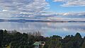
Looking east across Lake George after prolonged rainfall in 2022


See also
 In Spanish: Lago George (Australia) para niños
