
Lake St Clair (Tasmania) facts for kids
Quick facts for kids Lake St Clair |
|
|---|---|

Lake St Clair from Echo Point with Mount Ida to the left
|
|

Lake St Clair
Location in Tasmania
|
|
| Location | Central Highlands, Tasmania |
| Coordinates | 42°4′S 146°10′E / 42.067°S 146.167°E |
| Type | Freshwater lake |
| River sources |
|
| Primary outflows | River Derwent |
| Basin countries | Australia |
| Designation | |
| Max. length | 15 km (9.3 mi) |
| Max. width | 3 km (1.9 mi) |
| Surface area | 45 km2 (17 sq mi) |
| Max. depth | 215 m (705 ft) |
| Surface elevation | 737 m (2,418 ft) AHD |
Lake St Clair, also known as leeawulenna, is a beautiful natural freshwater lake in the Central Highlands of Tasmania, Australia. It's a very special place because it forms the southern part of the famous Cradle Mountain-Lake St Clair National Park.
This lake is quite large, covering about 45 square kilometres (17 sq mi). It's also incredibly deep, reaching a maximum depth of 215 metres (705 ft). This makes Lake St Clair the deepest lake in all of Australia! Water flows into the lake from the Narcissus River, Cuvier River, and Hamilton Creek. The River Derwent then starts its journey from Lake St Clair.
The area around the lake is managed by different local councils. The southern end of the lake is about 106 kilometres (66 mi) north-west of the town of Hamilton.
Contents
How Was Lake St Clair Formed?
Lake St Clair was created a very long time ago by glaciers. Imagine giant sheets of ice slowly moving across the land. As they moved, they carved out the valleys and the basin where the lake now sits. This process is called glacial erosion.
A Look Back in Time: Lake St Clair's History
Lake St Clair is located near the traditional lands of the Big River Tasmanian Aboriginal people. Evidence shows they hunted on the nearby grassy plains. Many small quarries and campsites have been found, with some sites showing human activity from as far back as 10,000 years ago.
The first European explorer to see the lake was a surveyor named William Sharland in 1832. Three years later, George Frankland led an expedition to the lake. In 1840, James Calder created a path from the lake to Macquarie Harbour. Later, Burgess made a more practical track. This Burgess track was used by miners until 1883. After that, a new, lower route was found, which eventually became the Lyell Highway.
From 1860, people used the area around the lake for hunting animals for their fur. This continued until the fur trade declined in the 1950s, even though it became illegal to hunt furs from 1927.
In 1937, a dam was built on the Derwent River just below the lake. A pumping station was also installed. This allowed Hydro Tasmania to lower the lake's water level by up to 6 meters to send water to the Tarraleah Power Station. These changing water levels caused some damage to the environment around the lake. The pumphouse stopped being used in the 1990s and was turned into a hotel in 2015.
The Cradle Mountain-Lake St Clair area has been protected for a long time. It was declared a scenic reserve in 1922 and a wildlife reserve in 1927. It became a national park in 1947 and a World Heritage Site in 1982.
Exploring the Lake St Clair Area
The entire area around Lake St Clair covers about 839.4 square kilometres (324.1 sq mi). The lake itself takes up about 45 square kilometres (17 sq mi) in the south-east corner. The Cradle Mountain-Lake St Clair National Park covers all of this area, as well as the Cradle Mountain area to the north.
You can reach the southern shore of the lake by car using the C193 route, also known as Lake St Clair Road.
Tourism and Fun Activities
Lake St Clair has been a popular spot for visitors for a long time. In 1871, a Tasmanian guidebook mentioned how beautiful the scenery was, even though few people visited. By 1900, there was a boatshed, places to stay, and better access at Cynthia Bay. The first tourists arrived by car in 1915.
The famous Overland Track to Cradle Mountain started to take shape in 1911. The route was officially marked by Bert Nichols in 1931.
A guesthouse was built at Cynthia Bay in 1930, and later, improved parking, camping, and visitor facilities were added. Today, the lake is a popular tourist spot. Many visitors come to walk, take photos, and learn about the area's history.
In 2015, an "eco-friendly" resort was completed at Pumphouse Point on Lake St Clair. This was allowed by the Tasmanian Government to encourage more tourism in national parks.
Gallery
-
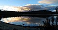
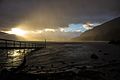
Lake St Clair sunset
-

Lake St Clair from Echo Point
-
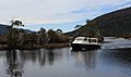
Our ride down Lake St. Clair
-
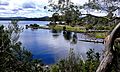
Lake St Clair NP Tas
-
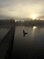
Swallow in the mist of dawn, Pumphouse Point, Lake St Clair
-
Echo Point, Lake St Clair at dawn


See also
 In Spanish: St Clair (lago) para niños
