Lancaster, Kansas facts for kids
Quick facts for kids
Lancaster, Kansas
|
|
|---|---|

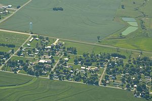
Aerial view of Lancaster (2013)
|
|

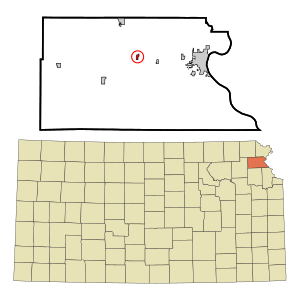
Location within Atchison County and Kansas
|
|

|
|
| Country | United States |
| State | Kansas |
| County | Atchison |
| Township | Lancaster |
| Founded | 1850s |
| Platted | 1857 |
| Named for | Lancaster, Pennsylvania |
| Area | |
| • Total | 0.20 sq mi (0.52 km2) |
| • Land | 0.20 sq mi (0.52 km2) |
| • Water | 0.00 sq mi (0.00 km2) |
| Elevation | 1,161 ft (354 m) |
| Population
(2020)
|
|
| • Total | 246 |
| • Density | 1,230/sq mi (473/km2) |
| Time zone | UTC−6 (CST) |
| • Summer (DST) | UTC−5 (CDT) |
| ZIP Code |
66041
|
| Area code | 913 |
| FIPS code | 20-38325 |
| GNIS ID | 2395625 |
Lancaster is a small city in Atchison County, Kansas, United States. In 2020, about 246 people lived there. It's a quiet place with a rich history in the state of Kansas.
Contents
History of Lancaster
Lancaster was officially planned out in 1857. It might have been named after a city called Lancaster, Pennsylvania. In its early days, Lancaster was considered a strong candidate to become the main town, or "county seat," for Atchison County.
The city was also an important stop on the Missouri Pacific Railroad. This railroad helped connect Lancaster to other places. By 1915, Lancaster had grown to include seven stores, a school, three churches, a grain elevator (for storing crops), a lumber yard, and even a hotel.
Geography of Lancaster
Lancaster is located in the state of Kansas. The United States Census Bureau says that the city covers a total area of about 0.22 square miles (0.52 square kilometers). All of this area is land, meaning there are no large lakes or rivers within the city limits.
Population of Lancaster
The number of people living in Lancaster has changed over the years. Here's a look at how the population has grown and shrunk:
| Historical population | |||
|---|---|---|---|
| Census | Pop. | %± | |
| 1900 | 292 | — | |
| 1910 | 220 | −24.7% | |
| 1920 | 184 | −16.4% | |
| 1930 | 188 | 2.2% | |
| 1940 | 163 | −13.3% | |
| 1950 | 200 | 22.7% | |
| 1960 | 196 | −2.0% | |
| 1970 | 279 | 42.3% | |
| 1980 | 274 | −1.8% | |
| 1990 | 299 | 9.1% | |
| 2000 | 291 | −2.7% | |
| 2010 | 298 | 2.4% | |
| 2020 | 246 | −17.4% | |
| U.S. Decennial Census | |||
What the 2020 Census Shows
The 2020 United States census found that 246 people lived in Lancaster. There were 109 households and 73 families. Most of the people, about 96%, were white. About 3.6% of the population identified as being from two or more races. A small number, about 1.6%, were of Hispanic or Latino background.
Many households, about 39%, had children under 18 living there. Nearly half, 46.8%, were married couples. The average household had 2.8 people. The average family had 3.8 people.
About 21% of the population was under 18 years old. Another 16% were 65 years or older. The average age in Lancaster was 43.6 years. For every 100 females, there were about 95 males.
What the 2010 Census Showed
In the 2010 United States census, Lancaster had 298 people. There were 108 households and 87 families. Most residents, about 98%, were white.
About 39% of households had children under 18. Most households, 65.7%, were married couples living together. The average household size was 2.76 people. The average family size was 3.08 people.
The average age in the city was 40 years. About 28% of residents were under 18. About 12% were 65 years or older. The city had slightly more males (50.7%) than females (49.3%).
See also
 In Spanish: Lancaster (Kansas) para niños
 | Audre Lorde |
 | John Berry Meachum |
 | Ferdinand Lee Barnett |

