Landfall, Minnesota facts for kids
Quick facts for kids
Landfall
|
|
|---|---|

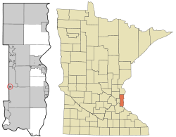
Location of the city of Landfall
within Washington County, Minnesota |
|
| Country | United States |
| State | Minnesota |
| County | Washington |
| Area | |
| • Total | 0.08 sq mi (0.21 km2) |
| • Land | 0.07 sq mi (0.17 km2) |
| • Water | 0.02 sq mi (0.04 km2) |
| Elevation | 968 ft (295 m) |
| Population
(2020)
|
|
| • Total | 843 |
| • Density | 12,772.73/sq mi (4,959.73/km2) |
| Time zone | UTC-6 (Central (CST)) |
| • Summer (DST) | UTC-5 (CDT) |
| ZIP code |
55128
|
| Area code(s) | 651 |
| FIPS code | 27-35414 |
| GNIS feature ID | 2395626 |
Landfall is a small city in Washington County, Minnesota, United States. In 2020, about 843 people lived there. It's the smallest community in Washington County by size. You can find Landfall on the eastern side of Tanner's Lake, right by Interstate 94.
Landfall is special because it's mainly a community of manufactured homes. This makes it one of the most affordable places to live in the Twin Cities area. In 2008 and 2010, the city was even recognized by America's Promise as one of the top 100 communities for young people. It's one of only two cities in Minnesota mostly made up of manufactured homes. The other is Hilltop.
Contents
A Brief History of Landfall
From 1953 to 1997, one family owned all the land in Landfall. Mobile homes were built there because people needed affordable places to live. The city officially became a city in 1959.
In the early 1990s, a company tried to buy the city to build a shopping mall. But the Washington County Housing and Redevelopment Authority stepped in. They bought the land and sold it to the city in 1997. Since then, the city has rented out lots for mobile homes to its residents. All the homes in Landfall are owned by the people who live in them. Renting out mobile homes is not allowed.
Where is Landfall Located?
The United States Census Bureau says Landfall covers a total area of about 0.09 square miles (0.23 square kilometers). Most of this area, about 0.07 square miles (0.18 square kilometers), is land. The rest, about 0.02 square miles (0.05 square kilometers), is water.
Interstate 94 is the main highway that goes through Landfall. Other major highways, Interstate 494 and Interstate 694, are also very close by. The border between Ramsey and Washington counties is also nearby.
Population and People
| Historical population | |||
|---|---|---|---|
| Census | Pop. | %± | |
| 1960 | 437 | — | |
| 1970 | 671 | 53.5% | |
| 1980 | 679 | 1.2% | |
| 1990 | 685 | 0.9% | |
| 2000 | 700 | 2.2% | |
| 2010 | 686 | −2.0% | |
| 2020 | 843 | 22.9% | |
| U.S. Decennial Census | |||
Landfall's Population in 2010
In 2010, the city of Landfall had 686 people living there. These people lived in 265 households, and 157 of these were families. Landfall was the most densely populated city in Minnesota at that time.
Most of the people in Landfall were White (69.5%). Other groups included African American (2.2%), Native American (3.2%), and Asian (3.8%). About 16% of the people were from other races, and 5.2% were from two or more races. A significant part of the population, 25.8%, was of Hispanic or Latino background.
About 35.8% of households had children under 18. Around 28.7% were married couples. Some households had a female head (15.8%) or a male head (14.7%) without a spouse. About 31.3% of all households were individuals living alone. The average household had 2.59 people.
The average age in Landfall was 35 years old. About 28.6% of residents were under 18. People aged 25 to 44 made up 28.2% of the population. The city had slightly more males (51.3%) than females (48.7%).
See also

- In Spanish: Landfall (Minnesota) para niños
 | Sharif Bey |
 | Hale Woodruff |
 | Richmond Barthé |
 | Purvis Young |

