Lansdowne, Maryland facts for kids
Quick facts for kids
Lansdowne, Maryland
|
||
|---|---|---|

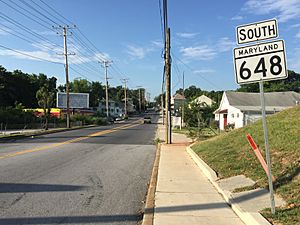
View south along Maryland State Route 648 (Annapolis Road) entering Lansdowne
|
||
|
||

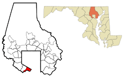
Location of Lansdowne in Maryland
|
||
| Country | ||
| State | ||
| County | ||
| Established | 1892 | |
| Area | ||
| • Total | 2.40 sq mi (6.23 km2) | |
| • Land | 2.28 sq mi (5.90 km2) | |
| • Water | 0.13 sq mi (0.33 km2) | |
| Population
(2020)
|
||
| • Total | 9,004 | |
| • Density | 3,956.06/sq mi (1,527.19/km2) | |
| Time zone | UTC−5 (Eastern (EST)) | |
| • Summer (DST) | UTC−4 (EDT) | |
| ZIP code |
21227
|
|
| Area code | 410 and 443 | |
| FIPS code | 24-45650 | |
Lansdowne is a community in southern Baltimore County, Maryland, in the United States. It is located just south of the city of Baltimore. In 2020, about 9,004 people lived there. Lansdowne is called a "census-designated place" (CDP), which means it's a specific area the government uses for counting people.
Contents
History of Lansdowne
Early Days and Mining
In the late 1800s, a company called Whitaker Iron mined for iron ore in Lansdowne. After they stopped mining, underground springs filled the empty pits. This created many small ponds and lakes. At that time, Lansdowne was mostly farmland, with large farms like the Kessler, MacLeod, and Wades farms.
The Railroad Era
When the B&O railroad came to Lansdowne, it became known as a "B&O town." Many people worked for the B&O and traveled by train to Baltimore for their jobs. The first train station was called Coursey Station. Today, a senior housing center in the area is named after this old station.
Main Roads and Churches
The two main roads in early Lansdowne were Hammonds Ferry Road and Hollins Ferry Road. Both of these roads led to the Patapsco River, where people used to cross by ferry. Early churches in the area included the Lutheran Church of Our Savior and St. Clements Catholic Church. The Hull Memorial Christian Church is a very old building, listed on the National Register of Historic Places in 1977.
Growth and Education
In the 1950s, many new houses were built in the Riverview area of Lansdowne. New schools were also built for the growing number of families. These schools included Lansdowne Elementary School, Lansdowne Middle School, and Lansdowne Senior High. People often called them the "Golden Education Triangle."
Changes in Transportation
In the early 1960s, the B&O railroad closed its crossing. To help people get around, Lansdowne Boulevard was built. This new road connected Lansdowne to Washington Boulevard and went over the railroad tracks. A tunnel was also built under the tracks for people to walk through. However, this change divided the community into two parts.
Community Spaces
In the 1980s, Baltimore County opened a large park for everyone to enjoy. This park, called Southwest Area Park, is located on the Patapsco River. It's a great place for outdoor activities.
A small library was built in Lansdowne in 1966. It was later closed in 1993 but reopened in 2006, thanks to a lot of support from the Lansdowne Improvement Association. This group has helped make the community better and more beautiful. They even helped get a special sign installed to welcome visitors to Lansdowne.
Geography of Lansdowne
Lansdowne is located at 39°14′35″N 76°39′30″W / 39.24306°N 76.65833°W. It has clear boundaries that help define its area. To the northeast, it borders the city of Baltimore. To the northwest, it is separated from Arbutus by the old Baltimore and Ohio Railroad tracks, which are now used by CSX Transportation.
The Patapsco River forms Lansdowne's southern border, separating it from Anne Arundel County. To the east, the Baltimore–Washington Parkway divides Lansdowne from Baltimore Highlands.
Lansdowne covers a total area of about 6.2 square kilometers (2.4 square miles). Most of this area, about 5.9 square kilometers (2.28 square miles), is land. The rest, about 0.3 square kilometers (0.13 square miles), is water.
Main Roads in Lansdowne
Lansdowne Road
Lansdowne Road is an important road that goes through Lansdowne and into South Baltimore. It starts at Hollins Ferry Road and travels west. It passes Lansdowne High School before reaching Hammonds Ferry Road and then Washington Boulevard.
Hollins Ferry Road
This road begins in the Halethorpe area at Halethorpe Farms Road. It goes east, crossing over I-695. After passing Lansdowne Road and Daisy Avenue, it crosses into Baltimore City. It ends at US-1 and Washington Boulevard.
Hammonds Ferry Road
Hammonds Ferry Road starts in Anne Arundel County at Andover Road in Linthicum Heights. It travels north, crossing into Lansdowne. It goes under the Baltimore Beltway and the Harbor Tunnel Thruway. Finally, it meets Hollins Ferry Road and continues until it reaches Caton Avenue and Patapsco Avenue.
Population and People
| Historical population | |||
|---|---|---|---|
| Census | Pop. | %± | |
| 1960 | 13,134 | — | |
| 1970 | 17,770 | 35.3% | |
| 1980 | 16,759 | −5.7% | |
| 1990 | 15,509 | −7.5% | |
| 2000 | 15,724 | 1.4% | |
| 2010 | 8,409 | −46.5% | |
| 2020 | 9,004 | 7.1% | |
| Separated from Lansdowne-Baltimore Highlands CDP in 2010 Census | |||
In 2010, there were 8,409 people living in Lansdowne. These people lived in 3,057 households, and 2,132 of these were families. The population density was about 1,351 people per square kilometer (3,513 people per square mile).
The people living in Lansdowne come from many different backgrounds. In 2010, about 67% of the population was White, and 23.9% was African American. About 2.1% were Asian, and 0.2% were Native American. People of Hispanic or Latino background made up about 7.7% of the population.
About 28.6% of the people in Lansdowne were under 18 years old. About 11% were 65 years or older. The average age of people in Lansdowne was about 30.8 years old.
See also
 In Spanish: Lansdowne (Maryland) para niños
 | Tommie Smith |
 | Simone Manuel |
 | Shani Davis |
 | Simone Biles |
 | Alice Coachman |


