Lansdowne, New South Wales facts for kids
Quick facts for kids LansdowneSydney, New South Wales |
|||||||||||||||
|---|---|---|---|---|---|---|---|---|---|---|---|---|---|---|---|

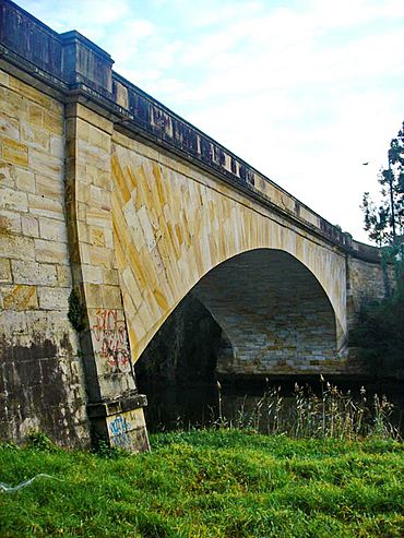
Lansdowne Bridge over Prospect Creek on the Hume Highway
|
|||||||||||||||

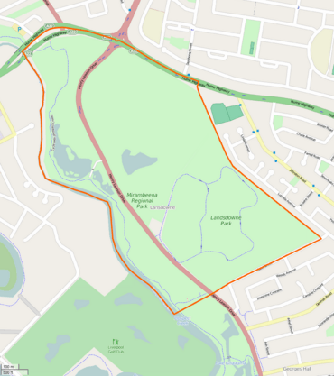
Boundaries of Lansdowne
|
|||||||||||||||
| Population | 17 (2016 census) | ||||||||||||||
| Postcode(s) | 2163 | ||||||||||||||
| Elevation | 11 m (36 ft) | ||||||||||||||
| Location | 27 km (17 mi) west of Sydney CBD | ||||||||||||||
| LGA(s) | City of Canterbury-Bankstown | ||||||||||||||
| State electorate(s) | Bankstown | ||||||||||||||
| Federal Division(s) | Blaxland | ||||||||||||||
|
|||||||||||||||
Lansdowne is a suburb located in south-western Sydney, New South Wales, Australia. It's about 27 kilometres west of the main city centre. Lansdowne is part of the City of Canterbury-Bankstown area. Its western side is next to Prospect Creek, the north is bordered by the Hume Highway, and Georges Hall is to its east and south.
Contents
History of Lansdowne
Lansdowne got its name from the famous Lansdowne Bridge. The bridge was named by Governor Richard Bourke to honour Henry Petty-Fitzmaurice, 3rd Marquess of Lansdowne. He was an important British politician from the 1800s. Sometimes, in the past, the suburb's name was spelled 'Landsdowne' on maps.
Early Development of the Area
In the 1880s, the land where Lansdowne is now was divided into smaller blocks for houses. Roads were even planned, but not many homes were actually built. Later, a water and drainage company bought the land. It stayed mostly empty, with its unused streets hidden among grasslands and trees.
Because much of Lansdowne was once owned by this water company, it is now mostly made up of beautiful parkland.
Henry Lawson Drive and Scout Jamborees
In the 1940s, a road called Henry Lawson Drive was built through Lansdowne. It was meant to be a scenic route, offering nice views.
This area has also been used for big events. In 1960 and 1961, the sixth Australian Scout Jamboree was held here. Later, in 1970, a smaller Scout event called a "jamborette" took place. This was part of the celebrations for the 75th birthday of the Bankstown area.
Creating Mirambeena Regional Park
In 1974, the Australian government bought the land from the water company. They wanted to turn it into a large open space for everyone to enjoy. Ownership was then given to the Bankstown Council. This land is now known as Mirambeena Regional Park.
Over the next few years, the park was made ready for people to use. This included creating Lake Gillawarna and other small ponds filled with water life. They also added walking and cycling paths, playgrounds, and places for barbecues and picnics.
Getting Around Lansdowne
Lansdowne has some important features related to transport, including a historic bridge and a unique road structure.
Lansdowne Bridge
The Lansdowne Bridge is a very old and important bridge. It was built between 1834 and 1835. The stone for the bridge came from the banks of the Georges River. This bridge replaced an older wooden one that often got washed away by floods.
The Lansdowne Bridge was designed by a skilled stonemason named David Lennox. He came to Sydney in 1832 to help build stronger bridges. Since 1958, a second bridge was built next to it. Now, the original Lansdowne Bridge only carries northbound traffic on the Hume Highway.
The Meccano Set Intersection
A well-known landmark in Lansdowne is called the "Meccano Set." It's a large metal structure that holds traffic lights and road signs. It sits above the busy intersection where the Hume Highway, Henry Lawson Drive, and Woodville Road meet. The first structure was put up in 1962, and a very similar new one was installed in 2019.
Parks and Green Spaces
Lansdowne is special because it's almost entirely made up of parkland. This means there are lots of green spaces for people to enjoy.
- Mirambeena Regional Park: This is a large park with Lake Gillawarna, walking paths, and picnic areas.
- Lansdowne Park: This park has a special track for road cycling.
 | Janet Taylor Pickett |
 | Synthia Saint James |
 | Howardena Pindell |
 | Faith Ringgold |

