LaRue County, Kentucky facts for kids
Quick facts for kids
LaRue County
|
|
|---|---|

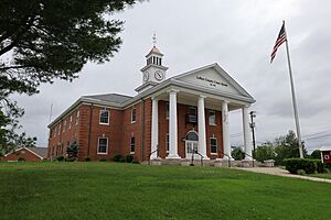
LaRue County courthouse in Hodgenville in 2022
|
|

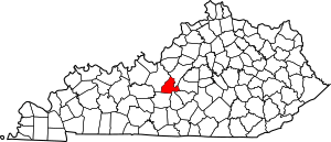
Location within the U.S. state of Kentucky
|
|
 Kentucky's location within the U.S. |
|
| Country | |
| State | |
| Founded | 1843 |
| Named for | John LaRue |
| Seat | Hodgenville |
| Largest city | Hodgenville |
| Area | |
| • Total | 264 sq mi (680 km2) |
| • Land | 262 sq mi (680 km2) |
| • Water | 2.1 sq mi (5 km2) 0.8% |
| Population
(2020)
|
|
| • Total | 14,867 |
| • Estimate
(2023)
|
15,303 |
| • Density | 56.31/sq mi (21.74/km2) |
| Time zone | UTC−5 (Eastern) |
| • Summer (DST) | UTC−4 (EDT) |
| Congressional district | 2nd |
LaRue County is a special area called a county in the middle of Kentucky, a state in the United States. It's not in the main "Bluegrass Region" or near very big cities. In 2020, about 14,867 people lived here.
The main town and government center of the county is Hodgenville. This town is famous because it's the birthplace of United States President Abraham Lincoln. LaRue County was created on March 4, 1843. It was named after John LaRue, who was an early settler in the area.
LaRue County is part of a larger group of towns called the Elizabethtown-Fort Knox area. It is also part of an even bigger area that includes Louisville and Bardstown in Kentucky, and parts of Indiana. The county is known as a "dry county," which means there are rules about selling alcohol.
Contents
Geography of LaRue County
LaRue County has gentle, rolling hills. Most of the land is used for farming or towns. Only the areas near rivers in the eastern part still have many trees. The highest point in the county is a small hill near the border with Taylor County. It is about 1,100 feet (335 meters) above sea level.
The county covers a total area of about 264 square miles (684 square kilometers). Most of this, about 262 square miles (679 square kilometers), is land. The rest, about 2.1 square miles (5.4 square kilometers), is water.
Neighboring Counties
LaRue County shares its borders with several other counties:
- Nelson County to the northeast
- Marion County to the east
- Taylor County to the southeast
- Green County to the south
- Hart County to the southwest
- Hardin County to the northwest
Special Protected Area
One important place in LaRue County is the Abraham Lincoln Birthplace National Historic Site. This is where Abraham Lincoln was born and is now a protected area.
People of LaRue County
In 2020, the population of LaRue County was 14,867 people. By 2023, it was estimated that about 15,303 people lived there. The number of people living in the county has slowly grown over many years.
Communities in LaRue County
LaRue County has a few towns and smaller communities where people live.
Cities
- Hodgenville: This is the county seat, meaning it's where the main government offices are.
- Upton: Part of this city is in LaRue County, but most of it is in Hardin County.
Census-Designated Places
These are areas that are like towns but are not officially incorporated as cities:
Other Communities
There are also several smaller, unincorporated communities in the county:
- Athertonville
- Ginseng
- Gleanings
- Lyons
- Malt
- Mount Sherman
- Tanner
- Tonieville
- White City
Lincoln Days Celebration
Every year, LaRue County hosts a special event called the Lincoln Days celebration. It happens on the first full weekend of October, from Friday to Sunday. This festival celebrates Abraham Lincoln's connection to the area.
Some fun things to see and do at Lincoln Days include:
- Lincoln Look-A-Like contests: People dress up and try to look like Abraham Lincoln.
- Rail-splitting competitions: This is a nod to Lincoln's early life, where people compete to split logs.
- A parade: A lively parade goes through the town.
- Shopping booths: You can find many unique items from local sellers.
- Concerts: Local musicians perform different types of music, often country, bluegrass, and Southern gospel.
See also
 In Spanish: Condado de LaRue para niños

