Marion County, Kentucky facts for kids
Quick facts for kids
Marion County
|
|
|---|---|

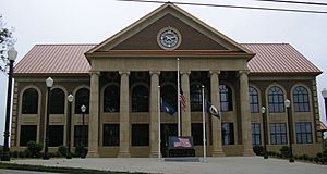
Marion County courthouse in Lebanon
|
|

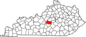
Location within the U.S. state of Kentucky
|
|
 Kentucky's location within the U.S. |
|
| Country | |
| State | |
| Founded | 1834 |
| Named for | Francis Marion |
| Seat | Lebanon |
| Largest city | Lebanon |
| Area | |
| • Total | 347 sq mi (900 km2) |
| • Land | 343 sq mi (890 km2) |
| • Water | 3.9 sq mi (10 km2) 1.1% |
| Population
(2020)
|
|
| • Total | 19,581 |
| • Estimate
(2023)
|
19,834 |
| • Density | 56.43/sq mi (21.79/km2) |
| Time zone | UTC−5 (Eastern) |
| • Summer (DST) | UTC−4 (EDT) |
| Congressional district | 1st |
Marion County is a place in Kentucky, a state in the United States. In 2020, about 19,581 people lived here. The main town, or county seat, is Lebanon. Marion County was started in 1834. It was named after Francis Marion, a brave hero from the American Revolutionary War. People called him the "Swamp Fox"!
Contents
Exploring Marion County's Geography
Marion County covers a total area of about 347 square miles. Most of this is land, around 343 square miles. A small part, about 3.9 square miles, is water.
How Marion County Was Formed
Marion County was created in 1834. It was made from a part of Washington County.
A Special Place for Catholics
Marion County is known for having many Catholic residents. The first Catholic families settled here around 1790. They came to a place called Holy Cross, in the western part of the county.
The Center of Kentucky?
Some maps show that the very center of Kentucky is located in Marion County. It's about 3 miles northwest of Lebanon, near Kentucky Route 429. However, other nearby counties also claim to be the center. This is because different map-making methods can show slightly different results.
Neighboring Counties
Marion County shares its borders with several other counties:
- Washington County (to the north)
- Boyle County (to the northeast)
- Casey County (to the southeast)
- Taylor County (to the south)
- LaRue County (to the southwest)
- Nelson County (to the northwest)
Understanding Marion County's Population
The number of people living in Marion County has changed over the years. Here's a look at the population counts from different census years:
| Historical population | |||
|---|---|---|---|
| Census | Pop. | %± | |
| 1840 | 11,032 | — | |
| 1850 | 11,765 | 6.6% | |
| 1860 | 12,593 | 7.0% | |
| 1870 | 12,838 | 1.9% | |
| 1880 | 14,693 | 14.4% | |
| 1890 | 15,648 | 6.5% | |
| 1900 | 16,290 | 4.1% | |
| 1910 | 16,330 | 0.2% | |
| 1920 | 15,527 | −4.9% | |
| 1930 | 15,499 | −0.2% | |
| 1940 | 16,913 | 9.1% | |
| 1950 | 17,212 | 1.8% | |
| 1960 | 16,887 | −1.9% | |
| 1970 | 16,714 | −1.0% | |
| 1980 | 17,910 | 7.2% | |
| 1990 | 16,499 | −7.9% | |
| 2000 | 18,212 | 10.4% | |
| 2010 | 19,820 | 8.8% | |
| 2020 | 19,581 | −1.2% | |
| 2023 (est.) | 19,834 | 0.1% | |
| U.S. Decennial Census 1790-1960 1900-1990 1990-2000 2010-2020 |
|||
In 2000, there were 18,212 people living in the county. The population density was about 53 people per square mile. Most residents were White (89.17%), and about 9.12% were Black or African American. A small percentage of the population was of Hispanic or Latino background (0.79%).
Communities in Marion County
Marion County has several towns and smaller communities.
Cities
- Bradfordsville
- Lebanon (This is the county seat, the main town for government.)
- Loretto
- Raywick
Unincorporated Communities
These are smaller places that are not officially organized as cities:
Education in Marion County
All schools in Marion County are part of the Marion County School District. The main high school for the area is Marion County High School.
Lebanon also has a lending library, called the Marion County Public Library. It's a great place to find books and learn new things!
See also
 In Spanish: Condado de Marion (Kentucky) para niños
 | George Robert Carruthers |
 | Patricia Bath |
 | Jan Ernst Matzeliger |
 | Alexander Miles |

