Latah, Washington facts for kids
Quick facts for kids
Latah, Washington
|
|
|---|---|

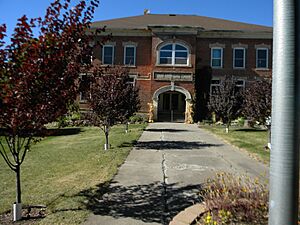
Historic Latah School
|
|

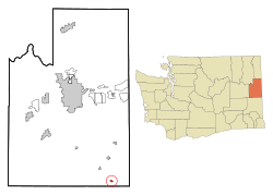
Location of Latah, Washington
|
|
| Country | United States |
| State | Washington |
| County | Spokane |
| Area | |
| • Total | 0.32 sq mi (0.83 km2) |
| • Land | 0.32 sq mi (0.83 km2) |
| • Water | 0.00 sq mi (0.00 km2) |
| Elevation | 2,510 ft (765 m) |
| Population
(2020)
|
|
| • Total | 185 |
| • Density | 578/sq mi (222.9/km2) |
| Time zone | UTC-8 (Pacific (PST)) |
| • Summer (DST) | UTC-7 (PDT) |
| ZIP code |
99018
|
| Area code | 509 |
| FIPS code | 53-38495 |
| GNIS feature ID | 1512380 |
Latah is a small town located in Spokane County, Washington, in the United States. In 2020, about 185 people lived there. The town gets its name from a nearby stream called Latah Creek. The word "Latah" comes from a native language and means "fish." Before it was called Latah, the town had other names like Hangman's Creek and Alpha.
Contents
History of Latah
Latah was first settled in 1872 by a person named Lewis Coplen. The town officially became a recognized town on April 9, 1892. It has always been connected to the nearby Latah Creek, which gave the town its name.
Geography of Latah
Latah is located in Washington state. Its exact location is at coordinates 47.281714 degrees North and -117.156634 degrees West.
According to the United States Census Bureau, the town covers a total area of about 0.31 square miles (0.83 square kilometers). All of this area is land, with no water.
Population Changes in Latah
The number of people living in Latah has changed over the years. Here's how the population has grown and shrunk:
| Historical population | |||
|---|---|---|---|
| Census | Pop. | %± | |
| 1890 | 232 | — | |
| 1900 | 253 | 9.1% | |
| 1910 | 339 | 34.0% | |
| 1920 | 330 | −2.7% | |
| 1930 | 284 | −13.9% | |
| 1940 | 270 | −4.9% | |
| 1950 | 244 | −9.6% | |
| 1960 | 190 | −22.1% | |
| 1970 | 169 | −11.1% | |
| 1980 | 155 | −8.3% | |
| 1990 | 175 | 12.9% | |
| 2000 | 151 | −13.7% | |
| 2010 | 183 | 21.2% | |
| 2020 | 185 | 1.1% | |
| U.S. Decennial Census | |||
Latah's Population in 2010
In 2010, there were 183 people living in Latah. These people lived in 67 different homes, and 50 of these were families. The town had about 590 people per square mile. There were 81 housing units in total.
Most of the people in Latah were White (88.5%). A smaller number were Native American (2.7%), Asian (0.5%), or from other backgrounds. About 6.0% of the population identified as Hispanic or Latino.
Many homes (37.3%) had children under 18 living there. Most households (64.2%) were married couples. Some homes (19.4%) had only one person living in them. The average household had 2.73 people, and the average family had 3.22 people.
The average age of people in Latah was 37.6 years old. About 27.9% of residents were under 18. About 8.7% were 65 years old or older. The town had slightly more females (54.6%) than males (45.4%).
See also
 In Spanish: Latah (Washington) para niños
 | James B. Knighten |
 | Azellia White |
 | Willa Brown |

